

FootSec
Jan-Hendrik Hanekom · Navigation
Independent analytics for this App Store listing. AppTracker is not affiliated with Jan-Hendrik Hanekom.
Chart standing · US
What changed · US
Listing changes AppTracker has observed for this app in this storefront — new versions, price moves, rating shifts, and store copy.
Animal icons added
In-app purchases · US
What this app sells inside itself, grouped by kind and priced for this storefront.
Screenshots






Keywords this app targets
Search terms AppTracker associates with this app — estimates, not search volume. ❝ = in the app's title; a highlighted number is its current position for that term.
Similar apps
Competitors and close alternatives, as estimated by AppTracker.
 Footpath Route Planner
Half Mile Labs LLC
Footpath Route Planner
Half Mile Labs LLC
 Kruger Nav
Robert Sutcliffe
1 shared topic
Kruger Nav
Robert Sutcliffe
1 shared topic
 Pocket Earth PRO
GeoMagik LLC
1 shared topic
Pocket Earth PRO
GeoMagik LLC
1 shared topic
 GoLog · Footprints
敏 李
1 shared topic
GoLog · Footprints
敏 李
1 shared topic
 Pocket Earth Maps
GeoMagik LLC
Pocket Earth Maps
GeoMagik LLC
 KrugerGuide
Kruger Guide Proprietary Limited
KrugerGuide
Kruger Guide Proprietary Limited
 Alpine Quest Nav PRO
Dogukan ERDAGI
Alpine Quest Nav PRO
Dogukan ERDAGI
 FootPrint: Map your travels
Tiago Almeida
FootPrint: Map your travels
Tiago Almeida
About
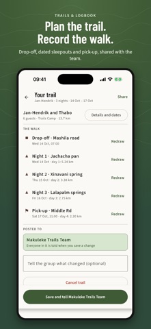
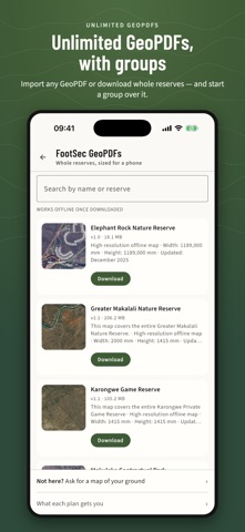
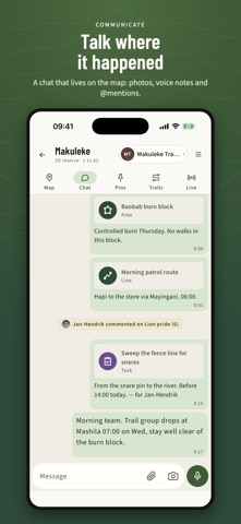
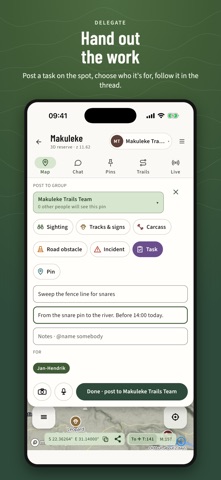
FootSec is the offline map for people who work on foot in the bush — field guides, trails guides, rangers, anti-poaching teams and reserve managers — and a shared map for the teams they work in. Make a group over any map and your whole team works from it: what one person marks in the field reaches everyone as soon as there is signal. No more sightings, road reports and waterhole news lost in a busy chat — in FootSec every message is tied to a place on the map. GROUPS — SHARE, TALK AND HAND OUT THE WORK • Make a group over a 3D map or a GeoPDF and invite your team with a code or a link • Share points instantly: drop a pin and everyone sees it on their own map — sightings, tracks & signs, carcasses, incidents, tasks and places • Talk on the map: a group chat with photos, voice notes, @mentions and private messages • Delegate: post a task where the job is, @mention who takes it and follow it in the pin's own thread • Live positions: see where your team is and how long ago each position was sent (opt-in, every 1, 2, 5 or 10 minutes) • Share trails and walks, with dated sleepouts so other guides know which dates to avoid • Notifications set per person; owner, admin and member roles; export the group's pins as GPX, CSV or a PDF report PREMIUM 3D INTERACTIVE MAPS • Real 3D terrain of the reserve — tilt and turn it, or switch to aerial photography • Roads, rivers, springs, waterholes, dams, viewpoints and camps, every one tappable • Set a waterhole to Dry, Low, Good or Full, report a road closed or 4x4 only, book a viewpoint — the whole group sees it • Download the map once and it works with no signal at all • 3D maps come as a yearly map seat: your lodge, reserve or team gives you a code that opens the map, with FootSec Full included UNLIMITED GEOPDF MAPS — WITH GROUPS • Import any georeferenced PDF — from Mail, Files or a chat — and see yourself on it • Download FootSec's own GeoPDFs: whole reserves, sized for a phone • Make a group over a GeoPDF too. A guide on the 3D map and a guide on a GeoPDF of the same reserve share one group and see each other's pins FIELD TOOLS — FREE • Record your walk with distance and time • Plan a trail: drop-off, dated sleepouts and pick-up • Logbook: every walk kept, map by map • Measure distances on the map • Draw lines and areas on your own layers • Pins with photos and voice notes • Import and export KMZ, KML, GPX, GeoJSON, CSV and Shapefile • Everything works offline and is sent when you reach signal; pins keep the time they were seen, not the time the phone found signal FREE TO USE FootSec is free. Every field tool works on one map of your own. No account needed, no adverts. FOOTSEC FULL — BUY ONCE, NEVER AGAIN One payment, yours to keep. No subscription. • Unlimited maps of your own • Every GeoPDF in FootSec's library • Join your team's groups and start your own • Restore Purchases brings it back on a new iPhone — no FootSec account needed to buy FOR LODGES & RESERVES Team packs put every guide on one map with one code — hand out seats and take one back when someone leaves. Private maps are built from your own data and opened only by your people. Nothing for your ground yet? Ask us in the app to build a map of your reserve or concession. Location: FootSec uses your location to show you on the map and record your walks. Your position is shared with a group only if you switch Live positions on. Made in South Africa by IlalaDevelopers, for people who walk.
What's new · 2.7.1
Animal icons added
Details