

Alpine Quest Nav PRO
Dogukan ERDAGI · Navigation
Independent analytics for this App Store listing. AppTracker is not affiliated with Dogukan ERDAGI.
Chart standing · US
What changed · US
Listing changes AppTracker has observed for this app in this storefront — new versions, price moves, rating shifts, and store copy.
New in version 1.2.2: • Field points: a handheld GPS in your pocket • Automatic trail and "Go back the way I came" • Safety: Sunset warning, Man-down alarm, Send position by SMS • Walk-around area measurement • Map compass and one-tap north • Sharper, more vivid map • Coordinates follow your settings • Mining theme • iPhone: routes and distance now keep recording with the screen off
In-app purchases · US
No in-app purchases.
Screenshots




Keywords this app targets
Search terms AppTracker associates with this app — estimates, not search volume. ❝ = in the app's title; a highlighted number is its current position for that term.
Similar apps
Competitors and close alternatives, as estimated by AppTracker.
 Alpin Quest PRO – Outdoor GPS
mustafa pistofoglu
2 shared title words
Alpin Quest PRO – Outdoor GPS
mustafa pistofoglu
2 shared title words
 Tactical MAP PRO : Navigation
mustafa pistofoglu
1 shared title word
Tactical MAP PRO : Navigation
mustafa pistofoglu
1 shared title word
 Guru Maps Pro - Offline Nav
Evgen Bodunov
2 shared title words
Guru Maps Pro - Offline Nav
Evgen Bodunov
2 shared title words
 MGRS & UTM GPS Maps PRO
mustafa pistofoglu
1 shared title word
MGRS & UTM GPS Maps PRO
mustafa pistofoglu
1 shared title word
 MilGPS+
mustafa pistofoglu
1 shared topic
MilGPS+
mustafa pistofoglu
1 shared topic
 Tactical GPS - MGRS Land Nav
Ivan Blajic
Tactical GPS - MGRS Land Nav
Ivan Blajic
 Maps 3D PRO - Hike & Bike
movingworld GmbH
1 shared title word
Maps 3D PRO - Hike & Bike
movingworld GmbH
1 shared title word
 MGRS GPS: Grid & Land Nav
Dajiale
1 shared title word
MGRS GPS: Grid & Land Nav
Dajiale
1 shared title word
About
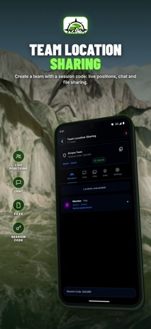
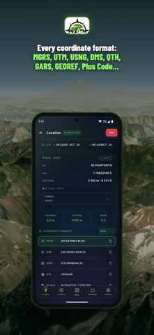
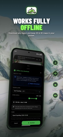
Lose the signal, not your way. Alpin Quest PRO is the offline GPS and topo map app for hunters, backpackers, overlanders, search-and-rescue teams and hikers who go past the end of the trail. Plan on satellite or topo maps, download them before you leave, navigate by MGRS, USNG or UTM, record every mile and keep your whole crew on one live map. No ads, no clutter. BUILT FOR HOW YOU GO OUT • Hunting: mark stands, blinds, trail cams, water and sightings as targets with photos and notes — then navigate back to them in the dark • Backpacking & hiking: offline topo, 3D terrain, slope map, elevation profiles and ETA from your real speed • Overlanding: download whole regions, record tracks with battery profiles, share GPX/KML with your convoy • Search & rescue: MGRS/USNG grids, search areas, team roles, live positions and PDF briefing maps MAPS THAT WORK OFFLINE • Satellite, satellite hybrid, topographic, street, Esri, OpenTopoMap and CartoDB layers • Field Terrain map: trails, named streams, dry creek beds, contours, peaks and villages • OpenStreetMap names: streams, valleys, pastures and springs • Slope map, tactical night and SAR layers, red-light night mode • Download any area for offline use (MBTiles) — 2D and 3D • Bring your own maps: MBTiles, GeoPackage, GeoTIFF, GeoPDF, raster KMZ — also via "Open in" from Files and other apps • Layer opacity, order and overlays; 22x overzoom, full screen and landscape NAVIGATE BY ANY GRID • Decimal, DMS, DDM, UTM, MGRS, USNG, BNG, GARS, GEOREF, QTH, Plus Code • USNG and MGRS for SAR and emergency response; BNG grid references for UK hill walking • ED50, CK-42 and India DSM datums • Type lat/lon, UTM or MGRS into separate fields with a hemisphere switch • Adaptive MGRS/UTM grid and lat/lon grid with edge labels • True, magnetic and grid north with declination and convergence • Go to target: live bearing, distance, ETA from real speed and off-route warning • Crosshair readout: live azimuth, distance and elevation • AR Surroundings: peaks, targets and teammates on your camera view TARGETS, TRACKS & ROUTES • Targets with categories, icons, notes and custom attributes • Multiple photos, audio notes and videos per target • Track recording with battery profiles, track folders and slope-colored elevation profile • Routes with terrain profile; areas as polygon or circle with vertex editing • Delete or hide targets, tracks, routes and areas right on the map YOUR TEAM ON ONE MAP • Join a Team Room with a 6-digit code • Live positions of every member and team chat • Live sync of targets, routes, areas, drawings and tracks with Admin, Editor and Observer roles PLAN, DRAW & MEASURE • Briefing drawing with line width, dashed lines and arrowheads • Distance, area, mil and fire sector tools; slope ruler • Scaled PDF maps with grid, legend, north diagram and atlas pages IMPORT & EXPORT • Import GPX, KML/KMZ, GeoJSON, DXF, Shapefile (zip), CSV • Export all of these plus CSV-UTM and DXF-UTM FIELD INFO & SAFETY • Weather: temperature, wind, humidity, dew point, cloud base, fog risk • Sun and moon: sunrise, sunset, twilight, moon phase • Elevation in feet or meters; imperial and metric units • SOS alarm with your coordinates in a message ready to share INTERFACE • Light, Dark and Tactical themes, 32 languages PRIVACY • Tracks, targets, photos, audio and videos stay on your device • Data leaves the device only for team features and online map/weather services • Crash reports (Firebase Crashlytics) contain technical error data only and can be turned off in Settings • No ads SUPPORT Join our WhatsApp support group from Settings for questions, bug reports and ideas. Map data © OpenStreetMap contributors and the respective map providers. Always carry a backup navigation method in remote terrain. Continued use of GPS running in the background can decrease battery life.
What's new · 1.2.2
New in version 1.2.2: • Field points: a handheld GPS in your pocket • Automatic trail and "Go back the way I came" • Safety: Sunset warning, Man-down alarm, Send position by SMS • Walk-around area measurement • Map compass and one-tap north • Sharper, more vivid map • Coordinates follow your settings • Mining theme • iPhone: routes and distance now keep recording with the screen off
Details