

Submarius: Dive & Spearfishing
Roger VanDeburgh · Weather
Independent analytics for this App Store listing. AppTracker is not affiliated with Roger VanDeburgh.
Chart standing · US
What changed · US
Listing changes AppTracker has observed for this app in this storefront — new versions, price moves, rating shifts, and store copy.
• Clamming is now a primary activity, with its own verdict. • Better clarity in bays and sheltered water: we now work out the local wind sea where the wave model has no water, and measure fetch from the water rather than the shoreline. • Tides reach further into bays, and a few places that read as a flat zero tide now read correctly. • The mode picker only offers real transports under "how you get there". • A finer bite score map, and assorted fixes.
Ratings breakdown · US
The star breakdown behind this app's rating in this storefront.
In-app purchases · US
What this app sells inside itself, grouped by kind and priced for this storefront.
Screenshots




Keywords this app targets
Search terms AppTracker associates with this app — estimates, not search volume. ❝ = in the app's title; a highlighted number is its current position for that term.
Similar apps
Competitors and close alternatives, as estimated by AppTracker.
 Spearo: Spearfishing
Diana Dryn
2 shared topics · 1 shared title word
Spearo: Spearfishing
Diana Dryn
2 shared topics · 1 shared title word
 Pêche en Mer - Predisport
Charles VENAYRE
Pêche en Mer - Predisport
Charles VENAYRE
 Fish & Tides
Rivolu LLC
Fish & Tides
Rivolu LLC
 SurfMap: Your Surf Forecast
Guillaume Bernos
SurfMap: Your Surf Forecast
Guillaume Bernos
 SeaState
Tom Curry
SeaState
Tom Curry
 Session Scout Weather Forecast
Paddle Logger Ltd.
Session Scout Weather Forecast
Paddle Logger Ltd.
 BuoyPilot
Elk Ridge Systems LLC
BuoyPilot
Elk Ridge Systems LLC
 Marine Forecast App - Boat8
Leveling LP
Marine Forecast App - Boat8
Leveling LP
About
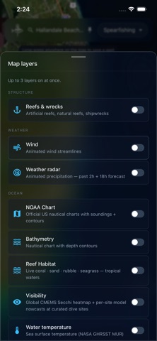
Submarius reads the ocean and reports everything you need to know to make a decision. Dive weather, bite forecast, and water clarity forecast for spearfishing, diving, fishing, and boating — built for people who are tired of stitching together four apps to decide if today is worth the drive. App Sections: - Conditions Dashboard - Map (with reefs and wrecks, live/forecasted radar, water clarity overlay, wind, and more) - Fish (what species can I expect to find at my set location, what are the laws and regulations, images of the fish) Every factor — wind, swell, tide, moon, pressure, water temp, water clarity — goes into a single 0–10 verdict you can read in two seconds. Tap any factor to see the numbers and the reasoning. No black-box "AI" — every input is transparent. Water Clarity Forecast No other major app has this. Submarius blends satellite turbidity (NOAA CoastWatch Kd490), USGS river-plume detection, wave-mixing physics, and community post-dive reports into an honest Secchi-depth estimate with explicit uncertainty. Grounded in Lee et al. 2015 (R²=0.96). When we don't know, we say so. Activity Modes Spearfishing, freediving, scuba, rod-and-reel fishing, boating, sailing, surfing, kayak/SUP. Each mode reweights the verdict around what actually matters for that activity — clarity and tide for spearos, swell period and wind for surfers, bite windows for anglers, small-craft advisories for boaters. Bite Score Dive forecast with water clarity, bite score, swell, tide, and moon — every factor explained. Tide stage, moon phase, solunar windows, barometric trend, wind, and water temperature — combined into a 0–10 score, factor by factor. No secret formula. If we score a day a 3, you'll know exactly why. Map Layers Self-hosted bathymetry + sea-surface temperature + animated weather radar + wind particle flow + reef and wreck structure overlays. Finds drop-offs, temp breaks, and shelter without dragging you to another app. Live GPS Tracks Record your dive or fishing trip as a live blue track on the map. Useful for retracing drift, marking productive zones, or just remembering the line you swam. Safety, Always Free Shark-tag alerts (OCEARCH), community shark sightings, SOS, and buddy GPS sharing are permanently free for every user, every tier. No paywall, no trial — by design. Privacy by default Your spots stay your spots. GPS-fuzzed to ~1 km on anything public; precise location never leaves your device unless you explicitly share it. Post-dive clarity reports ship with H3-fuzzed coordinates only — we can't give away where you dive because we never see it. Anonymous Current conditions, 2-day forecast, basic bite score, and every safety feature work without an account. Sign up when you want to save spots or post catches. Submarius Pro Pro unlocks the 8-day forecast, premium map overlays, offline maps, unlimited saved spots, advanced bite score layers, full water-clarity horizons, and catch history export. $12.99/month or $99/year with a 7-day free trial. Limited $149 lifetime tier for the first 1,000 founders. Subscriptions bill through your Apple ID and renew automatically unless cancelled at least 24 hours before the end of the current period. Manage in Settings → Apple ID → Subscriptions. Privacy: https://submarius.com/privacy Terms: https://submarius.com/terms
What's new · 1.3.37
• Clamming is now a primary activity, with its own verdict. • Better clarity in bays and sheltered water: we now work out the local wind sea where the wave model has no water, and measure fetch from the water rather than the shoreline. • Tides reach further into bays, and a few places that read as a flat zero tide now read correctly. • The mode picker only offers real transports under "how you get there". • A finer bite score map, and assorted fixes.
Details