

GoGIS
GoGIS LLC · Business
Independent analytics for this App Store listing. AppTracker is not affiliated with GoGIS LLC.
Chart standing · US
What changed · US
Listing changes AppTracker has observed for this app in this storefront — new versions, price moves, rating shifts, and store copy.
Walk to Draw with the Screen Locked Walk to Draw now keeps recording with your phone locked or in your pocket. The lock screen shows the points, distance and GPS accuracy, with a Stop button. If iOS closes GoGIS during a walk, nothing is lost: the next time you open the project, GoGIS offers the walk back so you can finish it. The first time, iOS asks whether GoGIS may keep using your location and show the walk on the lock screen: choose Allow, or the walk can’t carry on while locked. Buffer: see what it touches In Interactive Buffer, pick a layer under Touching. As you change the distance, the features the buffer reaches light up, with a count and the area it covers inside them. Select Touched makes them the selection. The distance slider now scales with what you selected, up to 10 km.
Ratings breakdown · US
The star breakdown behind this app's rating in this storefront.
In-app purchases · US
No in-app purchases.
Screenshots




Keywords this app targets
Search terms AppTracker associates with this app — estimates, not search volume. ❝ = in the app's title; a highlighted number is its current position for that term.
Similar apps
Competitors and close alternatives, as estimated by AppTracker.






About
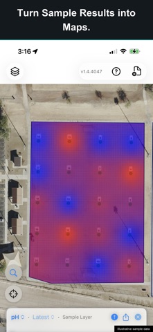
GoGIS brings your GIS data, field records, and spatial analysis together on iPhone and iPad. Explore detailed maps, inspect infrastructure, plan sampling work, and analyze features on location. Use your existing GIS files, keep observations connected to the map, and share the results. One-time purchase. No subscription or account required. EXPLORE YOUR DATA Open Shapefile, GeoJSON, KML, KMZ, GeoPackage, and CSV files. Combine layers, color features by attribute, and add labels to reveal patterns. Work with large parcel and infrastructure datasets, then inspect individual features. Search, sort, filter, and edit records in the attribute grid. Update individual values or apply changes across selected features. ANALYZE ON LOCATION Use Buffer, Intersect, Difference, and Dissolve on layers or selected features. Find parcels within a chosen distance of a site. Subtract mapped wetlands and measure the remaining area. Intersect soil classifications with field boundaries. Interactive Buffer lets you adjust the distance and preview the result before saving. CAPTURE FIELD RECORDS Build custom forms with pick lists, measurements, multiple-choice fields, ratings, and calculated values. Conditional fields show follow-up questions when they apply. Attach photos, scan barcodes, capture signatures, and make field drawings. Record observations with their GPS location, even without cell coverage. KEEP EVERY VISIT WITH THE ASSET Use related forms to retain separate inspections, readings, or maintenance records against the same feature. Photograph an obstruction, record its condition, and specify an action. Add the next inspection without replacing earlier records. Compare visits in the grid to see what changed. PLAN SAMPLES AND MAP RESULTS Generate numbered sample grids within a boundary. Adjust spacing, rotation, and offset. Follow a route with direction and distance to the next sample, while tracking completed locations and remaining work. Print QR or barcode bag labels and record each collection. Import lab results from CSV files, matching the lab’s identifier to your sample field. Keep successive results linked to the same locations. Create interpolated surfaces from values such as pH, nutrients, or elevation. Clip results to field boundaries and compare patterns on a shared color scale. BRING YOUR IMAGERY Import GeoTIFF or MBTiles imagery alongside your vector layers. Use satellite, aerial, or drone imagery to give features context. Convert GeoTIFF on the device, adjust opacity, and arrange layers to suit the work. WORK OFFLINE Imported vector data and field records stay on your device. View layers, collect observations, and run geometry operations without an internet connection. Download supported USGS basemaps in the United States or GSI basemaps in Japan before leaving coverage. Built-in basemap downloads are limited to those regions; imported vector data remains available offline elsewhere. COLLECT WITH GPS See live GPS accuracy while collecting or navigating, and save accuracy with collected points. Draw points, lines, and polygons manually, or use Walk to Draw to add locations as you move. Supported external GPS receivers can also be used. EXCHANGE WORK BETWEEN DEVICES Field Sync exchanges project changes between nearby GoGIS devices over a local connection. Transfer feature records, related forms, and photos without a cloud account. SHARE THE RESULTS Create PDF maps with a legend, scale bar, and north arrow. Generate sampling reports with overview maps and mapped result pages. Export layers as GeoJSON, KML, Shapefile, or CSV, and export related records for further work. Choose from more than 90 coordinate systems for Shapefile output.
What's new · 1.4.4155
Walk to Draw with the Screen Locked Walk to Draw now keeps recording with your phone locked or in your pocket. The lock screen shows the points, distance and GPS accuracy, with a Stop button. If iOS closes GoGIS during a walk, nothing is lost: the next time you open the project, GoGIS offers the walk back so you can finish it. The first time, iOS asks whether GoGIS may keep using your location and show the walk on the lock screen: choose Allow, or the walk can’t carry on while locked. Buffer: see what it touches In Interactive Buffer, pick a layer under Touching. As you change the distance, the features the buffer reaches light up, with a count and the area it covers inside them. Select Touched makes them the selection. The distance slider now scales with what you selected, up to 10 km.
Details