

TopoKit: Offline Field GIS
Nikolay Senilov · Navigation
Independent analytics for this App Store listing. AppTracker is not affiliated with Nikolay Senilov.
Chart standing · US
In-app purchases · US
No in-app purchases.
Screenshots






Keywords this app targets
Search terms AppTracker associates with this app — estimates, not search volume. ❝ = in the app's title; a highlighted number is its current position for that term.
Similar apps
Competitors and close alternatives, as estimated by AppTracker.
 GIS Kit
Garafa, LLC
1 shared topic · 1 shared title word
GIS Kit
Garafa, LLC
1 shared topic · 1 shared title word
 Locus GIS PRO - Field GPS
mustafa pistofoglu
Locus GIS PRO - Field GPS
mustafa pistofoglu
 TopoRec - Map Viewer
Enrico Hoffmann
2 shared topics
TopoRec - Map Viewer
Enrico Hoffmann
2 shared topics
 GoGIS
GoGIS LLC
GoGIS
GoGIS LLC
 GPS Kit - Offline GPS Tracker
Garafa, LLC
1 shared topic · 1 shared title word
GPS Kit - Offline GPS Tracker
Garafa, LLC
1 shared topic · 1 shared title word
 MapOut
Valnova
1 shared topic
MapOut
Valnova
1 shared topic
 MapLab Survey – GIS Measure
Sevket PARLAZ
MapLab Survey – GIS Measure
Sevket PARLAZ
 Topo GPS - Topographic maps
rdzl
Topo GPS - Topographic maps
rdzl
About
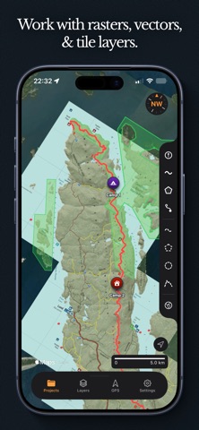
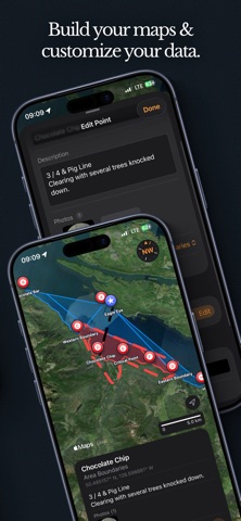
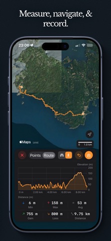
TopoKit is a mapping app for people who actually work with maps. Not a desktop GIS crammed onto a phone, and not a hiking app pretending to handle professional data. TopoKit sits in the middle: powerful enough for GeoTIFFs and coordinate systems, simple enough to set up a field map in minutes. Built for geologists, ecologists, foresters, and anyone who takes maps into the real world. PROJECTS THAT ORGANIZE YOUR WORK Everything lives in a project. Import your rasters, vectors, and tile layers, then organize them in a hierarchical layer tree with folder nesting and drag-and-drop reordering. Control visibility and opacity per layer. Save, reopen, and sync across devices. BRING YOUR OWN DATA Import GeoTIFFs, GeoPDFs, GPX, KML, KMZ, GeoJSON, and GeoPackage. Connect to XYZ or WMS tile servers. Export in any format with your metadata intact. RASTERS THAT JUST WORK Drop a GeoTIFF or GeoPDF and it lands exactly where it belongs on your base map. Automatic CRS detection across 6,000+ coordinate systems with on-the-fly reprojection and per-layer opacity control. No manual georeferencing. OPEN ON YOUR MAC. WALK OUT THE DOOR. Build your field map on your Mac. Import rasters, set up your layers, customize your styles. When you're ready, grab your iPhone and everything is already there. Projects, rasters, vectors, downloaded tiles, all synced through your personal iCloud. Pin projects for guaranteed offline access. TAKE IT INTO THE FIELD Download tiles from your connected tile servers for offline use. Select an area, pick your zoom levels, and take your maps where there's no cell service. Record GPS tracks with three accuracy profiles and auto-pause. Measure distance, area, and bearing on the map. Attach photos to any feature. STYLES, SEARCH, AND ROUTING Save and reuse style presets for pins, lines, and polygons. Customize icons per folder. Search by place name, coordinate in any format, or feature name. Create routes and elevation profiles. YOUR DATA STAYS YOURS No accounts. No analytics. No tracking. Your data lives on your devices and syncs only through your iCloud. ONE PURCHASE. EVERY FEATURE. No subscriptions, no feature gating, no tiers. Pay once and you get the whole app. Built and supported by one developer. Questions, feedback, or feature requests? I'd love to hear from you. support@topokit.ca
What's new · 1.1
TopoKit 1.1 — the biggest update yet. DRAW AND MEASURE, TOGETHER Add Line, Add Polygon, and the new Add Circle tool show live measurements while you draw — distance, area, radius, and more, with tappable unit switching. Just measuring? Read the numbers and close the tool — nothing is saved unless you press Save. MUCH FASTER WITH BIG PROJECTS Importing large files is dramatically faster, the map stays smooth while you pan and zoom, and project files are about half their previous size — so they open quicker and sync less. BETTER IMPORTED MAPS Very large maps keep their full detail without running out of memory, misaligned georeferenced PDFs place correctly, several Canadian coordinate systems are fixed, and PDF maps redraw much faster while zooming and panning. CHOOSE HOW IMPORTED FILES LOOK New Imported Line and Imported Polygon styles in Settings let imports look the way you want — independent from your drawing styles. SMOOTHER STARTUP Your last project starts opening much faster with far less flicker in the first seconds. ALSO FIXED • "Open in TopoKit" from the Files app now imports into your project • Style editors no longer open half-empty on iPhone • Edit panels only save what you actually changed • GPS files with bad values can no longer block a project from saving
Details