

Altika: Peaks & Hiking
Jamel EL ABDELLAOUI · Travel
Independent analytics for this App Store listing. AppTracker is not affiliated with Jamel EL ABDELLAOUI.
Chart standing · US
What changed · US
Listing changes AppTracker has observed for this app in this storefront — new versions, price moves, rating shifts, and store copy.
You now choose whether Altika may measure how well its ads work. You are asked once, and can change your mind at any time in Settings > Privacy. No ads are shown in the app, and no advertising identifier is collected.
In-app purchases · US
What this app sells inside itself, grouped by kind and priced for this storefront.
Screenshots


Similar apps
Competitors and close alternatives, as estimated by AppTracker.
 isomaps
Iso-maps Geoservices SARL
isomaps
Iso-maps Geoservices SARL
 AR AlpineGuide
NYANKO SOFTWARE
AR AlpineGuide
NYANKO SOFTWARE
 Elevation Tracker: Altitude
Florian Delaunay
Elevation Tracker: Altitude
Florian Delaunay
 Hiking and Skiing - PeakVisor
Routes Software SRL
Hiking and Skiing - PeakVisor
Routes Software SRL
 RealityMaps 3D tour planner
3D RealityMaps GmbH
RealityMaps 3D tour planner
3D RealityMaps GmbH
 Above – Hiking & Summit Log
Rene Fischer
Above – Hiking & Summit Log
Rene Fischer
 Relief Maps : backcountry gps
Batiste Vonderweidt
Relief Maps : backcountry gps
Batiste Vonderweidt
 Hanglage - Skimo Computer
Bernhard Hering
Hanglage - Skimo Computer
Bernhard Hering
About
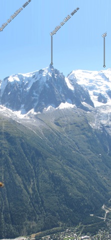
Point your iPhone at the mountains: Altika shows the name, elevation and distance of every summit, in augmented reality through the camera, as a panorama, or as a 3D flight over the real terrain. IDENTIFY SUMMITS, ANYWHERE • 74 735 named peaks are built into the app, including 2 118 above 4 000 m • Nearly a million more peaks download on demand, worldwide: Alps, Pyrenees, Highlands, Atlas, Himalaya, Rockies, Andes, Japan, New Zealand • Augmented reality: names sit directly on your camera image • Compass disturbed? One swipe realigns the view, the app stays 100 % usable • Summit sheet: elevation, distance, bearing, elevation angle, photo, Wikipedia, GPX / KML export, driving directions to the trailhead SEE THE TERRAIN IN 3D • Bird's-eye flight over any summit, on the real terrain of the whole planet • Aerial imagery draped over the relief (IGN Géoplateforme, Copernicus Sentinel-2) • Summit names stay pinned to the landscape during the flight PLAN AND FOLLOW YOUR HIKES • Over 15 500 built-in routes, distance and ascent recomputed on the terrain • Over 30 000 road and mountain-bike routes online, with the same tools • Europe is covered in depth: Austrian Alps, Vosges, Massif Central, Bavarian Alps, Pyrenees, French Alps, Jura, Apennines, Scottish Highlands, Corsica, Carpathians, Etna, Jotunheimen, Rila and Pirin, Mount Olympus • Elsewhere, the landmark ranges: Sierra Nevada and Colorado Rockies, Everest, Kilimanjaro, Fitz Roy, Cordillera Blanca, Japanese Alps, New Zealand • Long-distance trails also appear when they pass near you, not only when they start at your doorstep, with their reference ("GR 20", "GR 5") • 10 266 routes display their waymarks: the painted colour mark you actually follow on the rock, built in, so visible with no signal • On the map, long-distance trails are drawn in their waymark colour • Draw your own route: tap the map, Altika follows the trails, on foot, by bike or mountain bike • Create a loop: give a distance, Altika draws loops that come back to your starting point • Import your GPX files, or open a GPX received in a message • Record your outing: GPS track, automatic pause, readable summary (distance, ascent, total and moving time, estimated calories) • Voice guidance: remaining distance, off-trail alert, arrival time, even with the screen off • "What am I looking at?": the app names the summits out loud GENUINELY OFFLINE • 36 downloadable regions to take with you: map, terrain and imagery included • No connection needed in the mountains, no surprise while roaming • Your data stays on your iPhone: no account, no sign-up, no advertising • Your outings are yours: file backup and restore, GPX export at any time ONE PURCHASE, FOREVER • 3D relief flyover is free and unlimited, anywhere on the planet • Free, with no account and no sign-up: one guided hike, one created loop, Mont Blanc in 3D aerial imagery, and one peak in three named in augmented reality • Augmented reality never locks: camera, skyline, altitude and heading correction stay free, only the other peak names wait for the purchase • A single payment unlocks everything: the 36 offline regions, present and future, every name in augmented reality, aerial imagery on any summit in the world, and unlimited guidance • No subscription. No advertising. No catch. Altika is built in France by an independent developer, for hikers who want to know what they are looking at, without paying a subscription every year. Map data: OpenStreetMap (ODbL), SRTM, IGN Géoplateforme, Copernicus Sentinel-2, GeoNames. Photos: Wikimedia Commons.
What's new · 1.0.4
You now choose whether Altika may measure how well its ads work. You are asked once, and can change your mind at any time in Settings > Privacy. No ads are shown in the app, and no advertising identifier is collected.
Details