

isomaps
Iso-maps Geoservices SARL · Health & Fitness
Independent analytics for this App Store listing. AppTracker is not affiliated with Iso-maps Geoservices SARL.
Chart standing · US
What changed · US
Listing changes AppTracker has observed for this app in this storefront — new versions, price moves, rating shifts, and store copy.
Earth as a sphere Zoom out and the map becomes a globe: the whole Earth, with the stars, the Sun, the Moon, and night sweeping across the satellite imagery. The world is there instantly The worldwide Map and Satellite backgrounds are prepared over Wi-Fi at launch, so your globe is complete the moment you open it — even with no signal — and maps reload far less often. "What to bring" on your club sessions Whatever your coach asks you to pack — headlamp, poles, jacket — now shows up in the app, right below the session description. Declaring attendance: the right message The app now tells you exactly whether you can still declare a session, or whether the window has closed. Layer labels stay readable Wind speed, altitude: every point keeps its label, even where they sit close together.
In-app purchases · US
What this app sells inside itself, grouped by kind and priced for this storefront.
Screenshots



Similar apps
Competitors and close alternatives, as estimated by AppTracker.
 Mountain Maps: Hiking
MountainMaps SRL
Mountain Maps: Hiking
MountainMaps SRL
 Altika: Peaks & Hiking
Jamel EL ABDELLAOUI
Altika: Peaks & Hiking
Jamel EL ABDELLAOUI
 RealityMaps 3D tour planner
3D RealityMaps GmbH
RealityMaps 3D tour planner
3D RealityMaps GmbH
 Hiking and Skiing - PeakVisor
Routes Software SRL
Hiking and Skiing - PeakVisor
Routes Software SRL
 Hanglage - Skimo Computer
Bernhard Hering
Hanglage - Skimo Computer
Bernhard Hering
 Relief Maps : backcountry gps
Batiste Vonderweidt
Relief Maps : backcountry gps
Batiste Vonderweidt
 onX Backcountry: 3D Trail Maps
onXmaps, Inc.
onX Backcountry: 3D Trail Maps
onXmaps, Inc.
 Maps 3D - Hike & Bike
movingworld GmbH
Maps 3D - Hike & Bike
movingworld GmbH
About
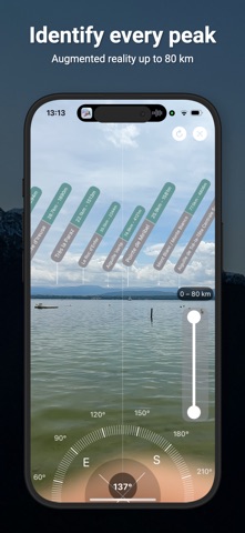
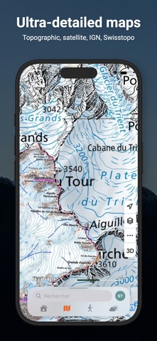
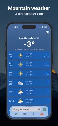
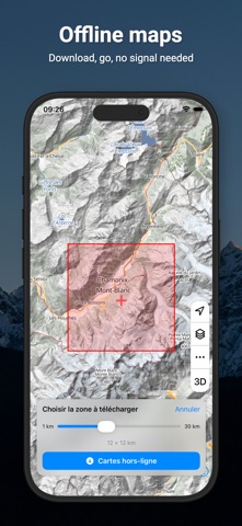
SEE THE MOUNTAINS LIKE NEVER BEFORE — AND TALK TO THEM Point your iPhone at the horizon: Isomaps instantly identifies every peak in augmented reality, up to 80 km away. And now, simply ask it for whatever you need — by voice or keyboard. Plan, record and share your outdoor adventures — even offline. ―――――――――――――――――――― NATURAL LANGUAGE SEARCH (NEW) • Ask by voice or keyboard: weather, snow, conditions, routes, your activities… • Built-in voice dictation, in the language of your choice • The app understands your intent and acts: opens the map, the right layer, the right day… AUGMENTED REALITY • Automatic peak identification with name and elevation • Detection range up to 80 km • Automatic compass mode on devices without AR SMART GPS TRACKING • Continuous background recording, resumes without data loss after an unexpected close • Automatic pause detection • Over 30 activity types: hiking, trail running, mountain biking, gravel, running, walking, ski touring, ski mountaineering, cross-country skiing, snowshoeing, mountaineering, climbing, kayaking, canoeing, paddleboarding, paragliding, swimming… plus adaptive activities (joelette, handcycling, sit-ski, wheelchair) • Heart rate zones (Karvonen) and a live screen of time per zone • Interactive elevation profile and GPX export LIVE TRACKING • Share your location in real time during an outing • Your loved ones follow your progress on the map • Ideal for mountain safety OFFLINE MAPS • Topographic, satellite and hybrid maps • Download an area to use it without a connection • Thematic layers: weather, avalanche, lightning • Search for places, peaks and coordinates MOUNTAIN WEATHER & CONDITIONS • Ultra-local high-resolution forecasts (Meteoblue), by the hour • Animated weather maps (temperature, clouds, precipitation) • Avalanche bulletin (EAWS) and snow cover by massif • Real-time lightning detection, air quality, climate alerts • Barometer with adjustable history, sunrise and sunset 3D FLYOVER • Replay your outings in 3D, and your friends' too • Video export to share your adventures BUILT-IN MESSAGING • Private conversations and groups • Voice messages, photos, files and links • Emoji reactions and search within conversations Stay connected with your group without leaving the app. OUTDOOR SOCIAL NETWORK • Add friends, follow other hikers • Activity feed from your friends and follows • Likes and comments, sharing with permissions, friend groups CUSTOMIZABLE DASHBOARD • Over 25 widgets: weather, stats, goals, records, streak, calendar, photos, period comparisons… • Rearrange and choose what matters to you ROUTES & TRACKS • Draw routes with road snapping • Import your GPX files, organize them into folders • Share with friends or via link INTEGRATIONS • Apple Health & Apple Watch, Garmin, Strava, Suunto, Polar • Physiological data: heart rate, cadence, power FREE TO START Isomaps is free with the essential features. The Premium subscription (Student pricing available) unlocks advanced layers, full offline mode, voice search and much more. ―――――――――――――――――――― Questions? Check the in-app FAQ or contact us at support@iso-maps.com Terms: https://www.iso-maps.com/terms Privacy: https://www.iso-maps.com/privacy
What's new · 4.6.0
Earth as a sphere Zoom out and the map becomes a globe: the whole Earth, with the stars, the Sun, the Moon, and night sweeping across the satellite imagery. The world is there instantly The worldwide Map and Satellite backgrounds are prepared over Wi-Fi at launch, so your globe is complete the moment you open it — even with no signal — and maps reload far less often. "What to bring" on your club sessions Whatever your coach asks you to pack — headlamp, poles, jacket — now shows up in the app, right below the session description. Declaring attendance: the right message The app now tells you exactly whether you can still declare a session, or whether the window has closed. Layer labels stay readable Wind speed, altitude: every point keeps its label, even where they sit close together.
Details