

GPS Satellite Tracker+
Kyu-Hee Jang · Utilities
Independent analytics for this App Store listing. AppTracker is not affiliated with Kyu-Hee Jang.
Chart standing · US
What changed · US
Listing changes AppTracker has observed for this app in this storefront — new versions, price moves, rating shifts, and store copy.
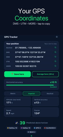
The first screen now shows your position in decimal, DMS, DDM, UTM and MGRS at once — tap any row to copy it. Save a place with a name or average 30 seconds of fixes, then rename it later. Switch to feet/mph or nautical units, see vertical accuracy, and a dash replaces made-up 0 m altitude or 0° course. The predicted sky now adds GLONASS, Galileo, BeiDou, QZSS and NavIC.
Price & rating history · US
Reconstructed from the listing changes AppTracker has observed in this storefront. A field is charted once it has changed more than once, and each line starts at the value it moved from.
Average rating · ★ 3.50 now · 4 changes on record
Ratings breakdown · US
The star breakdown behind this app's rating in this storefront.
Screenshots
Keywords this app targets
Search terms AppTracker associates with this app — estimates, not search volume. ❝ = in the app's title; a highlighted number is its current position for that term.
Similar apps
Competitors and close alternatives, as estimated by AppTracker.
 Elevation Tracker: Altitude
Florian Delaunay
Elevation Tracker: Altitude
Florian Delaunay
 GPS & Map Toolbox
Audama Software, Inc.
GPS & Map Toolbox
Audama Software, Inc.
 Sundowner – Sun & Moon
Henning Hock
Sundowner – Sun & Moon
Henning Hock
 Satellite Tracker°
Ridge Labs LLC
Satellite Tracker°
Ridge Labs LLC
 Field Maps Measure - Landmetr
Alexey Sakharov
Field Maps Measure - Landmetr
Alexey Sakharov
 GPS Trace - Track & Record
Sylvain MICHEL
GPS Trace - Track & Record
Sylvain MICHEL
 Alpine Quest Nav PRO
Dogukan ERDAGI
Alpine Quest Nav PRO
Dogukan ERDAGI
 UAV Forecast
Matthew LLOYD
UAV Forecast
Matthew LLOYD
About
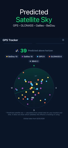
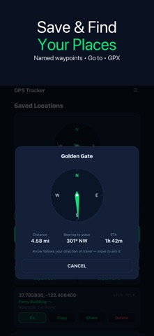
Read your exact position in every format at once — decimal degrees, DMS, DDM, UTM and MGRS — and copy any of them with one tap. YOUR POSITION, EVERY FORMAT • Five coordinate formats shown together on the first screen • Tap a row to copy that exact string for a map, a message or a form • Horizontal accuracy and vertical accuracy, shown separately • Altitude above sea level, ground speed and course over ground • Metric, imperial (feet, mph) or nautical (feet, knots, nautical miles) When the phone has no valid altitude or you are standing still, the app shows a dash instead of a made-up 0 m or 0°. SAVE AND FIND PLACES • Save here: store the current fix under a name you choose • Average here: collect up to 30 fixes over 30 seconds and save the mean, with an estimated uncertainty that never claims to be better than the fixes it came from • Rename or delete saved places at any time • Go to a saved place: distance, bearing and ETA, with an Arrived badge within 100 m. The arrow follows your GPS direction of travel, so it works while you are moving — it is not a magnetic compass • Export all saved places as CSV or GPX PREDICTED SATELLITE SKY A polar sky chart shows where the GPS, GLONASS, Galileo, BeiDou, QZSS, NavIC and SBAS satellites are above you right now, calculated with the standard SGP4 model from public orbital data (CelesTrak) for your position and time. The data refreshes weekly, a bundled copy works offline, and the date of the orbital data is shown under the chart. This is a prediction and the app labels it that way. iOS does not give apps per-satellite data, so the chart does not show which satellites your iPhone is receiving or using. A satellite list sorts everything by elevation. LOCK SCREEN While the app is open, a Live Activity shows accuracy, altitude, speed and course on the Lock Screen and in the Dynamic Island. The app does not track location in the background, so the card marks itself PAUSED instead of leaving an old reading looking current. GOOD FOR Hikers and paddlers checking a fix before relying on it · search and rescue, scouts and land navigation with MGRS or UTM · geocaching · drone and paragliding pilots · anyone who needs to send an exact position Readings come from your phone's own location services. Accuracy depends on the device and on a clear view of the sky. Available in 30 languages.
What's new · 1.1.25
The first screen now shows your position in decimal, DMS, DDM, UTM and MGRS at once — tap any row to copy it. Save a place with a name or average 30 seconds of fixes, then rename it later. Switch to feet/mph or nautical units, see vertical accuracy, and a dash replaces made-up 0 m altitude or 0° course. The predicted sky now adds GLONASS, Galileo, BeiDou, QZSS and NavIC.
Details