

Soundings Mobile
WeatherWary LLC · Weather
Independent analytics for this App Store listing. AppTracker is not affiliated with WeatherWary LLC.
Chart standing · US
What changed · US
Listing changes AppTracker has observed for this app in this storefront — new versions, price moves, rating shifts, and store copy.
Import GEMPAK archives Performance improvements for switching soundings Selecting stations and navigating the map no longer accidentally triggers a nearest-station lookup
Price & rating history · US
Reconstructed from the listing changes AppTracker has observed in this storefront. A field is charted once it has changed more than once, and each line starts at the value it moved from.
Average rating · ★ 0.00 now · 2 changes on record
Ratings breakdown · US
The star breakdown behind this app's rating in this storefront.
In-app purchases · US
No in-app purchases.
Screenshots


Keywords this app targets
Search terms AppTracker associates with this app — estimates, not search volume. ❝ = in the app's title; a highlighted number is its current position for that term.
Similar apps
Competitors and close alternatives, as estimated by AppTracker.
 Weather Gods
 Ltd
1 shared topic
Weather Gods
Weather Gods Ltd
1 shared topic
 Southerly
Terminal Velocity
1 shared topic
Southerly
Terminal Velocity
1 shared topic
 Spotter Tools Pro: Storm Radar
DUSTIN GARNER
Spotter Tools Pro: Storm Radar
DUSTIN GARNER
 Windy.com
Windyty, SE
1 shared topic
Windy.com
Windyty, SE
1 shared topic
 WillyWeather
 (AU) Pty Ltd
1 shared topic
WillyWeather
WillyWeather (AU) Pty Ltd
1 shared topic
 Clement - Find your weather
Ron Forrester
1 shared topic
Clement - Find your weather
Ron Forrester
1 shared topic
 WindScope,Learn Weather Charts
Creative4Vision
1 shared topic
WindScope,Learn Weather Charts
Creative4Vision
1 shared topic
 Weather4D Lite
APP4NAV
1 shared topic
Weather4D Lite
APP4NAV
1 shared topic
About
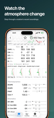
Soundings turns the twice-daily balloon launches over the United States into something you can actually read — a proper Skew-T log-P, a hodograph, and the full convective parameter set, on iPhone, iPad, and Mac. THE SKEW-T, DONE RIGHT • Classic 45° Skew-T log-P: temperature, dewpoint, and the parcel trace • CAPE and CIN shaded on the chart and labeled where they occur • Wind barbs in their own gutter; LCL, LFC, and EL marked on the profile • Optional wet-bulb and virtual-temperature traces • Pinch or scroll to zoom, drag to pan, double-tap to reset PARCELS SIDE BY SIDE Surface-based, mixed-layer, and most-unstable parcels in one table — CAPE, CIN, LCL, LFC, EL, and lifted index — so you can see which one the atmosphere is really offering. Draw any of them on the chart, or none. WIND, SHEAR, AND STORM MODE The hodograph plots the wind profile with Bunkers left- and right-moving storm motion and shaded storm-relative helicity. Alongside it: the effective inflow layer, 0–1 km / 0–3 km / effective SRH, effective bulk shear, and the composites you actually reach for — SCP, STP, SHIP, derecho, EHI, and large hail. Every value is drawn against its operational thresholds, so a number means something at a glance. The math matches SHARPlib. THE WHOLE NETWORK, ON A MAP Browse every reporting site from Alaska to Puerto Rico on a map, or search by name. The map shows which stations made the current cycle, so you know what's up there before you tap. Star a station and it loads at launch. WATCH IT EVOLVE A station's recent launches appear as postage-stamp Skew-Ts — step back through the cycles to watch a cap build, a dryline mix out, or moisture return. FAMOUS SOUNDINGS Eleven of the atmosphere's most-studied days, one tap away: the 1974 Super Outbreak, Bridge Creek–Moore, April 27 2011, Joplin, Moore 2013, El Reno, Hurricane Ian's landfall and inland deluge, the Buffalo lake-effect storm, and more. YOUR OWN DATA Open Wyoming text, WMO TEMP (FM 35), or BUFR (FM 94) files straight from Fil or Finder — a research sounding, an archived launch, a case study — and get same chart and the same numbers. MADE FOR EVERY SCREEN One app for iPhone, iPad, and Mac, with Imperial or SI units and adjustable text size.
What's new · 1.11
Import GEMPAK archives Performance improvements for switching soundings Selecting stations and navigating the map no longer accidentally triggers a nearest-station lookup
Details