

Spotter Tools Pro: Storm Radar
DUSTIN GARNER · Weather
Independent analytics for this App Store listing. AppTracker is not affiliated with DUSTIN GARNER.
Chart standing · US
What changed · US
Listing changes AppTracker has observed for this app in this storefront — new versions, price moves, rating shifts, and store copy.
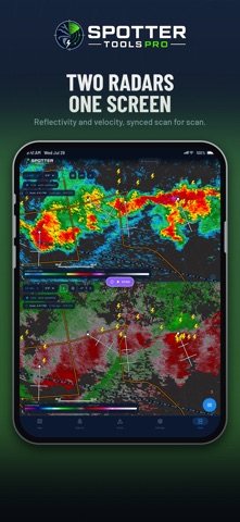
RADAR IN YOUR CAR: CARPLAY Spotter Tools Pro is now a CarPlay navigation app. • Live radar on your car's screen, with warning polygons, storm cells, storm reports and radar sites • Layers: Reflectivity, Velocity, Storm-relative velocity, Correlation coefficient or the National composite, plus warnings on or off and a dark or light map • Sites: follow the nearest radar automatically or pick one • Search a town, ZIP code or address, or pick a recent place or a storm nearby, then Go for turn-by-turn on CarPlay's own turn cards • A trip started on your iPhone shows up in the car, and End in the car ends it on both • Car alerts on the CarPlay screen, and simpler maps for the Dashboard and instrument cluster SPOKEN TURNS WITH YOUR PHONE LOCKED Directions now keep talking when your iPhone is locked or another app is in front. LIVE CHASER POSITIONS • A new map layer shows featured storm chasers who are streaming on YouTube right now and sharing their position on Spotter Network • Tap a marker to watch their live stream • Live chasers stay on the map for as long as Spotter Network lists them • Team channels show a marker for each member out chasing • Partner chasers get a gold-ringed marker with their photo: Jim McGonigle, New Mexico Storm Chasing and South Central Mississippi Storm Chasers SHARE BUTTON • A new Share button in the bottom bar captures the screen you are on, map included, with a footer showing the logo, spottertools.pro and the date and time DUAL VIEW • Every Level II product in both panes, including storm-relative velocity, spectrum width and normalized rotation • Two panes on one radar share each download, so side by side costs no more data • Search, Center on me, a radar site pick or an alert now move both panes • Dual view loops use no more memory than single view TROPICAL • Each named storm's position is a spinning storm symbol with its category in the eye, faster as it strengthens • Fixed a storm card time that was 3 hours early and a distance that could be 45 miles off • New advisories show within about 5 minutes, and typhoons get their real category BUOY DATA EXPORT • Export data on a NOAA buoy's camera card shares its last 5 days of reports as a spreadsheet file NATIONAL RADAR • Low + Mid rotation: both rotation levels on one map, striped where both are spinning • Smooth colour scales for rotation, hail size, echo tops, VIL, rain totals and precip rate, with a quiet grey wash for weak values • Reflectivity layers in the national product list now use your own colour table and gate filter RADAR FIXES • Archived Level 2 velocity loops no longer skip 30 to 60 minutes when the radar keeps changing its settings • One failed scan no longer ends a Level 2 loop early and drops every newer frame
Ratings breakdown · US
The star breakdown behind this app's rating in this storefront.
In-app purchases · US
No in-app purchases.
Screenshots






Keywords this app targets
Search terms AppTracker associates with this app — estimates, not search volume. ❝ = in the app's title; a highlighted number is its current position for that term.
Similar apps
Competitors and close alternatives, as estimated by AppTracker.
 Storm Radar: Weather Tracker
The Weather Channel Interactive
3 shared topics · 3 shared title words
Storm Radar: Weather Tracker
The Weather Channel Interactive
3 shared topics · 3 shared title words
 Clime: NOAA Weather Radar Live
Mosaic S.r.l.
3 shared topics · 1 shared title word
Clime: NOAA Weather Radar Live
Mosaic S.r.l.
3 shared topics · 1 shared title word
 Weather Radar: Storm Tracker
Hassan Mohamed Abdelrahman Attia
1 shared topic · 2 shared title words
Weather Radar: Storm Tracker
Hassan Mohamed Abdelrahman Attia
1 shared topic · 2 shared title words
 Storm NOAA Radar: Weather 24
Maxym Naryzhniy
2 shared topics · 2 shared title words
Storm NOAA Radar: Weather 24
Maxym Naryzhniy
2 shared topics · 2 shared title words
 Radar HD Future Weather Radar
Elecont LLC
2 shared topics · 1 shared title word
Radar HD Future Weather Radar
Elecont LLC
2 shared topics · 1 shared title word
 RadarOmega: Doppler Radar App
SDS Weather LLC
2 shared topics · 1 shared title word
RadarOmega: Doppler Radar App
SDS Weather LLC
2 shared topics · 1 shared title word
 RainAware
 LLC
2 shared topics
RainAware
RainAware LLC
2 shared topics
 ZoneWatch – Radar & Forecast
WeatherWise Innovations, Inc.
1 shared topic · 1 shared title word
ZoneWatch – Radar & Forecast
WeatherWise Innovations, Inc.
1 shared topic · 1 shared title word
About
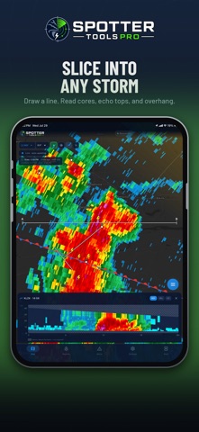
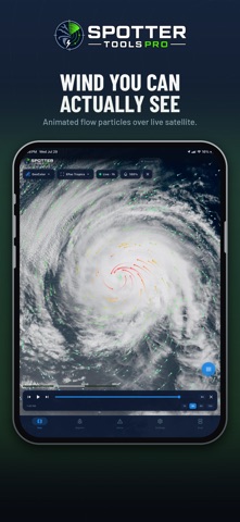
Spotter Tools Pro is a severe weather app for weather enthusiasts, storm chasers, and trained spotters. GPU-rendered NEXRAD radar, turn-by-turn directions, live wind flow, soundings, lightning, satellite, worldwide tropical, air quality, five forecast models, IBW alerts, live chasers, and thousands of live cameras. Plus Spotter Network reporting and Chaser Mode. Buy once. No subscription, no ads, no third-party trackers. TURN-BY-TURN DIRECTIONS Drive to any address, town, or map point with your route drawn over live radar and warnings. Turn banner with distance and arrival time, spoken prompts that lower your music, and automatic rerouting. Start from search or a long-press. SPOTTER NETWORK REPORTING & BEACON Tornado, funnel cloud, wall cloud, hail, measured wind, flood, flash flood, and damage, each with the exact fields Spotter Network expects. Reports queue offline and auto-upload. Foreground and background GPS beacon with a configurable interval. RADAR: LEVEL 2, LEVEL III & TDWR Crisp at any zoom. Single-site Level 2 decoded on-device: Reflectivity, Velocity, Correlation Coefficient, Spectrum Width, and Storm-Relative Velocity. Plus WSR-88D Level III, dual-pol (ZDR, CC, KDP, HCA), derived products (VIL, Digital Precip Rate, rotation), storm tracks, mesocyclone and TVS markers, a VAD Wind Profile, and the 45-site TDWR network. Add a Mesoanalysis layer (SPC-style severe parameters) and a Storm Cell Deep Dive. Dual-view split-screen compare. 16 .pal color tables, or import your own. ANIMATED & COMPOSITE RADAR Loop recent volumes. Add a GPU-crisp CONUS MRMS mosaic drawn from the full product catalog, including the FLASH flash-flood suite, with up to 12-hour playback and tap-to-read values. LIVE WIND & SOUNDINGS Animated surface-wind particles colored by speed. On-device skew-T soundings, hodographs, and full analysis: tap anywhere for a profile (balloon or HRRR). LIGHTNING, SATELLITE & TROPICAL Live GOES GLM lightning; GOES East and West satellite (Infrared, Water Vapor, Visible, GeoColor) with a radar-synced cloud loop; and worldwide tropical: outlook areas, storm cones, spaghetti tracks, intensity, and wind-arrival times. WEATHER MODELS Overlay HRRR, GFS, RRFS, NAM, and ECMWF guidance (reflectivity, temp, wind, CAPE, precip) with a time bar. OBSERVATIONS & LAYERS RTMA surface observations (temperature, dew point, theta-e, wind, gusts), MRMS observed precipitation, METARs, EPA AirNow air quality, and WPC surface fronts and pressure centers. LIVE STORM CHASERS Watch major chasers stream live via YouTube and Facebook Live, right on the map. Live badges show who's on air. LIVE TRAFFIC & SKY CAMERAS Tens of thousands of DOT cameras across 37 states, plus FAA, Windy, NOAA buoy, USGS volcano, NPS, ALERTWildfire, and curated webcams. Live video where offered, stills elsewhere. SMART PUSH ALERTS Background NWS warnings with a polygon preview. Filter modes: Standard, Outbreak, and PDS/Emergency only. Watch zones: current location, home, city, state, or nationwide. Severe-alert tone, plus optional Critical Alerts so a Tornado Emergency or PDS warning sounds through silent mode and Focus. Each warning shows an estimated population inside the polygon. NWS & SPC ON THE MAP - 50+ NWS warning polygons, toggleable - Tornado and severe thunderstorm watch boxes - SPC Mesoscale Discussions and WPC flood discussions, full text on tap - Outlooks: convective Day 1 to 8, thunderstorm, excessive rainfall, fire weather, winter storm severity, CPC 6 to 10 day, drought - SPC storm reports plus the live Spotter Network feed MORE City and place search, long-press map menu, distance and bearing tools, freehand drawing, and storm-track projection. Optional account and opt-in Presence to see other users on the map. Per-event colors, county and state lines, 6 themes (OLED black). Privacy Policy: https://spottertoolspro.vercel.app/privacy Terms of Service: https://spottertoolspro.vercel.app/terms Support: spottertoolspro@gmail.com
What's new · 1.0.74
RADAR IN YOUR CAR: CARPLAY Spotter Tools Pro is now a CarPlay navigation app. • Live radar on your car's screen, with warning polygons, storm cells, storm reports and radar sites • Layers: Reflectivity, Velocity, Storm-relative velocity, Correlation coefficient or the National composite, plus warnings on or off and a dark or light map • Sites: follow the nearest radar automatically or pick one • Search a town, ZIP code or address, or pick a recent place or a storm nearby, then Go for turn-by-turn on CarPlay's own turn cards • A trip started on your iPhone shows up in the car, and End in the car ends it on both • Car alerts on the CarPlay screen, and simpler maps for the Dashboard and instrument cluster SPOKEN TURNS WITH YOUR PHONE LOCKED Directions now keep talking when your iPhone is locked or another app is in front. LIVE CHASER POSITIONS • A new map layer shows featured storm chasers who are streaming on YouTube right now and sharing their position on Spotter Network • Tap a marker to watch their live stream • Live chasers stay on the map for as long as Spotter Network lists them • Team channels show a marker for each member out chasing • Partner chasers get a gold-ringed marker with their photo: Jim McGonigle, New Mexico Storm Chasing and South Central Mississippi Storm Chasers SHARE BUTTON • A new Share button in the bottom bar captures the screen you are on, map included, with a footer showing the logo, spottertools.pro and the date and time DUAL VIEW • Every Level II product in both panes, including storm-relative velocity, spectrum width and normalized rotation • Two panes on one radar share each download, so side by side costs no more data • Search, Center on me, a radar site pick or an alert now move both panes • Dual view loops use no more memory than single view TROPICAL • Each named storm's position is a spinning storm symbol with its category in the eye, faster as it strengthens • Fixed a storm card time that was 3 hours early and a distance that could be 45 miles off • New advisories show within about 5 minutes, and typhoons get their real category BUOY DATA EXPORT • Export data on a NOAA buoy's camera card shares its last 5 days of reports as a spreadsheet file NATIONAL RADAR • Low + Mid rotation: both rotation levels on one map, striped where both are spinning • Smooth colour scales for rotation, hail size, echo tops, VIL, rain totals and precip rate, with a quiet grey wash for weak values • Reflectivity layers in the national product list now use your own colour table and gate filter RADAR FIXES • Archived Level 2 velocity loops no longer skip 30 to 60 minutes when the radar keeps changing its settings • One failed scan no longer ends a Level 2 loop early and drops every newer frame
Details