

Vulture
Jelle Vandebeeck · Sports
Independent analytics for this App Store listing. AppTracker is not affiliated with Jelle Vandebeeck.
Chart standing · US
What changed · US
Listing changes AppTracker has observed for this app in this storefront — new versions, price moves, rating shifts, and store copy.
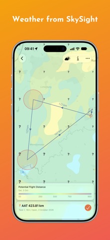
Vulture 4 is rebuilt around your logbook: a sidebar, a gallery of maps, a new map engine, Handoff between your devices — and, for the first time, a Mac app on the same subscription. New look * A sidebar leads everywhere: the map, your flights, tasks, airspace and waypoints, and Soaring Spot, WeGlide, Charron.line and SkyLines. * Every list can be a gallery, each flight and task a card with its track over a map of where it went. * Waypoint and airspace files have lists of their own: tap a file to show or hide it on the map, or rename it in place. * iPhone rotates to landscape, and every screen follows the size of its window — ready for iPhone Duo. * On iPad, open a flight or a task in a window of its own, with every action in the menu bar. Map * A new map engine, with a new Standard style, the earth as a globe when you zoom out, and long flights that draw faster. * More SkySight layers — surface temperature and dewpoint, pressure, freezing level, density altitude, ridge lift, and wave — named on a legend card on the map. * Share the flight map as an image, with the time, speed, climb and altitude at the glider. * Turn the phone or resize the window and the map keeps what it was showing. Analyze * A thermal is shown from above with the wind taken out — where you circled and where the lift was — and from the side, with the climb rate under the climb and a score for how well you centred it. * Flight photos open full screen, with the time, altitude, speed and climb when they were taken. * Sort the lists by date, distance, duration or speed; favorites and recorded flights are filters. * Files, under Discover, opens flights straight off the device without adding them to your logbook. * Switch off sport detection in Settings to have every flight analyzed as the sport you fly. Fly * Start recording from Control Center or the Action button, mark an event or stop and save from the Live Activity, and see the flight in the Apple Watch Smart Stack. * Recording carries on more reliably with the screen off, and the map no longer hitches on long flights. Discover * Soaring Spot, WeGlide, Charron.line and SkyLines open beside the sidebar: tap a flight to open it, select several to open them together, and search the results. * A Soaring Spot competition without results yet shows its pilots per class. * When a service cannot be reached, the screen says why and offers to try again. Everywhere * Handoff: a flight, a task, the map or a list carries over to your other iPhone, iPad or Mac, looking at what you were looking at. * Drag several flights or tasks into another app at once, or drop files onto a list to import them. * The settings are in seven groups, the same on every device. Fixed * Flights and tasks now appear in Spotlight — by date, pilot, glider, remarks or turnpoints. * OpenAir files in a Western European encoding import in a moment instead of minutes. * The average speed over the last hour, shown while recording, now covers the last hour. * The cloud button is only there where satellite images exist for the flight. * Two rare crashes while terrain and files were downloading.
Screenshots





Keywords this app targets
Search terms AppTracker associates with this app — estimates, not search volume. ❝ = in the app's title; a highlighted number is its current position for that term.
Similar apps
Competitors and close alternatives, as estimated by AppTracker.
 Aerofly FS Global
IPACS
Aerofly FS Global
IPACS
 Wingman: Paragliding Tracker
iSolid SPRL
Wingman: Paragliding Tracker
iSolid SPRL
 SkyPocket
John Mckay
SkyPocket
John Mckay
 Pilot Logbook - Logger
737 PUBLISHING S.R.O.
Pilot Logbook - Logger
737 PUBLISHING S.R.O.
 OnlyFlights: Flight Tracker
Katsiaryna Huryna
OnlyFlights: Flight Tracker
Katsiaryna Huryna
 Pilot Life - Flight Tracker
Paper Plane Ventures Inc.
Pilot Life - Flight Tracker
Paper Plane Ventures Inc.
 Air Navigation Pro
Air Navigation SA
Air Navigation Pro
Air Navigation SA
 ForeFlight Mobile EFB
ForeFlight
ForeFlight Mobile EFB
ForeFlight
About
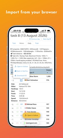
Vulture is a soaring planning and analysis app built for glider, paragliding, and hang gliding pilots. Plan a task on the day, fly it with live airspace and weather, then replay every thermal back on the airfield — on iPhone, iPad, and Mac. Plan * Build a task from waypoints, or import one from a CUP file, WeGlide, or SoaringSpot. * Scan a task from a QR code, as shared by XCTrack and the other gliding tools. * Edit any task to fit the weather of the day, with custom observation zones per turnpoint. * Check the day with dozens of SkySight weather layers — thermals, cloud cover, storms, rain, wind, and wave — before you commit to a task. * Export a task as a CUP file or a FLARM declaration for your IGC-approved device. * Import OpenAir, CUB, and openAIP airspace files, pull sets from XCSoar, or show openAIP airspace live on the map. Fly * See airspace and optimized flight information in the air, and navigate to any waypoint. * Start recording from Control Center or the Action button, and follow the flight on the Lock Screen and Apple Watch. * Look up the nearest airfield and its frequency, provided by OurAirports. * Long-press the map to see the airspace above that point as a vertical profile, with your own altitude marked in flight. * Your sport is detected automatically, or set by you, with matching thresholds for thermals, takeoff, and landing. Analyze * Browse your logbook as a gallery, each flight and task drawn on a map. * Replay one or more flights with a barograph and detailed statistics as you scrub through them. * Overlay satellite cloud imagery and scrub the barograph to see the clouds at each moment of a flight (requires SkySight). * Drag the graph handle for a calculated wind estimate at any point in a flight. * Take a thermal apart — the climb over time, from above, and from the side — with a score for how well you centred it. * Review optimized distance, release point, maximum altitude, and much more. * Add searchable remarks to saved flights, mark contests, and keep your favorites. * Compare flights side by side with leader/leecher analysis — who found the thermals first, and who followed. * Browse Soaring Spot, WeGlide, Charron, and SkyLines in the app, and upload your flights to them. Everywhere * Sync flights, tasks, waypoints, airspace, and all settings across your devices with iCloud. * Hand a flight, a task, or the map over to another device with Handoff. * Import flights by drag and drop, from Files, or straight from the share sheet. * Open flights and tasks directly in Vulture from SoaringSpot and Charron using the Chrome extension. * Share a Soaring Spot results link and it opens even without Vulture — that day's scoreboard, and every pilot's flight on a map. * Preview flight, waypoint, and airspace files in Files before you import them. * Find flights and tasks from Spotlight on your home screen. * Widgets for the wind at your home base, tomorrow's launch window, and a flight from your logbook — on the Home Screen, the Lock Screen, and in StandBy. * Windows of their own for flights and tasks on iPad, keyboard shortcuts, pointer support, and dark mode. Try every feature free during the trial. One subscription covers iPhone, iPad, and Mac — keep flying with Vulture by choosing a plan whenever you're ready. Tell us how we can make Vulture better. Terms of use: https://vulture.aero/terms
What's new · 4.0.0
Vulture 4 is rebuilt around your logbook: a sidebar, a gallery of maps, a new map engine, Handoff between your devices — and, for the first time, a Mac app on the same subscription. New look * A sidebar leads everywhere: the map, your flights, tasks, airspace and waypoints, and Soaring Spot, WeGlide, Charron.line and SkyLines. * Every list can be a gallery, each flight and task a card with its track over a map of where it went. * Waypoint and airspace files have lists of their own: tap a file to show or hide it on the map, or rename it in place. * iPhone rotates to landscape, and every screen follows the size of its window — ready for iPhone Duo. * On iPad, open a flight or a task in a window of its own, with every action in the menu bar. Map * A new map engine, with a new Standard style, the earth as a globe when you zoom out, and long flights that draw faster. * More SkySight layers — surface temperature and dewpoint, pressure, freezing level, density altitude, ridge lift, and wave — named on a legend card on the map. * Share the flight map as an image, with the time, speed, climb and altitude at the glider. * Turn the phone or resize the window and the map keeps what it was showing. Analyze * A thermal is shown from above with the wind taken out — where you circled and where the lift was — and from the side, with the climb rate under the climb and a score for how well you centred it. * Flight photos open full screen, with the time, altitude, speed and climb when they were taken. * Sort the lists by date, distance, duration or speed; favorites and recorded flights are filters. * Files, under Discover, opens flights straight off the device without adding them to your logbook. * Switch off sport detection in Settings to have every flight analyzed as the sport you fly. Fly * Start recording from Control Center or the Action button, mark an event or stop and save from the Live Activity, and see the flight in the Apple Watch Smart Stack. * Recording carries on more reliably with the screen off, and the map no longer hitches on long flights. Discover * Soaring Spot, WeGlide, Charron.line and SkyLines open beside the sidebar: tap a flight to open it, select several to open them together, and search the results. * A Soaring Spot competition without results yet shows its pilots per class. * When a service cannot be reached, the screen says why and offers to try again. Everywhere * Handoff: a flight, a task, the map or a list carries over to your other iPhone, iPad or Mac, looking at what you were looking at. * Drag several flights or tasks into another app at once, or drop files onto a list to import them. * The settings are in seven groups, the same on every device. Fixed * Flights and tasks now appear in Spotlight — by date, pilot, glider, remarks or turnpoints. * OpenAir files in a Western European encoding import in a moment instead of minutes. * The average speed over the last hour, shown while recording, now covers the last hour. * The cloud button is only there where satellite images exist for the flight. * Two rare crashes while terrain and files were downloading.
Details