

Aviation Weather Route Planner
Flygo-Aviation Ltd · Weather
Independent analytics for this App Store listing. AppTracker is not affiliated with Flygo-Aviation Ltd.
Chart standing · US
What changed · US
Listing changes AppTracker has observed for this app in this storefront — new versions, price moves, rating shifts, and store copy.
Route and group management rewritten for iPhone and iPad. • Decoded METAR redesigned: gusts, visibility, ceiling and what limits the flight category • TAF periods as cards with their own category and hazards (CB, icing, turbulence, wind shear) • Runway wind for every runway end, now and for each TAF period, with NOTAM closures marked • NOTAMs rebuilt: aerodrome and FIR items, category filters, critical items highlighted, offline cache • Map: flight category rings and legend, leg distance, course and ETE, alternates along the route now on iPad too • Faster, more relevant airport search with Return-to-add • Airport info page with approach data and decoded codes • Settings redesigned with pilot-friendly units, set for your region • Editing and deleting are now free; only storage beyond 5 airports needs Unlimited • Stability and performance improvements
Ratings breakdown · US
The star breakdown behind this app's rating in this storefront.
In-app purchases · US
What this app sells inside itself, grouped by kind and priced for this storefront.
Screenshots



About
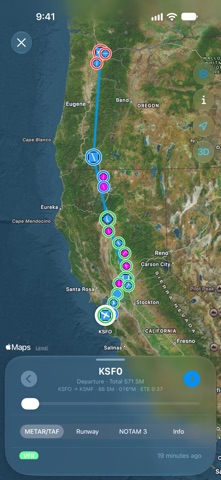
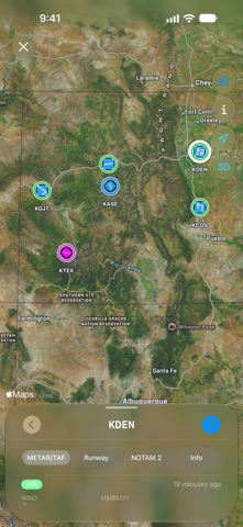
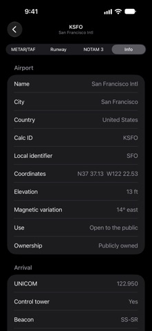
Plan the weather along your whole flight, not one airport at a time. Aviation Weather Route Planner shows METAR, TAF and NOTAM for every airport on your route — and the diversion options beside it — on one map, decoded and ready for your preflight briefing. ROUTE WEATHER AT A GLANCE Build a route from 50,000+ airports worldwide. Each airport on the map carries its flight category ring (VFR, MVFR, IFR, LIFR), and airports along the corridor appear automatically as alternates, each with its own weather. Step through the stops to see leg distance, magnetic course and ETE for your cruise speed. DECODED METAR & TAF Raw or decoded, your choice. See wind with gusts, visibility, ceiling, temperature/dew point spread warnings and what limits the flight category. TAF periods appear as cards — TEMPO, BECMG, FM and PROB — with their own category and hazards such as thunderstorms, cumulonimbus, icing, turbulence and wind shear. RUNWAY WIND Headwind, tailwind and crosswind for every runway end, now and for each TAF period. Runways closed by NOTAM are flagged right on the runway diagram. NOTAMS THAT MATTER NOTAMs for the aerodrome and its FIR, sorted into categories you can filter: runway, taxiway, navaid, obstacle, airspace and more. Critical items stand out, active-now and expiring-soon are marked, and the last download stays available offline. PILOT BRIEFING – OFFLINE Save a briefing with the METAR, TAF, NOTAM and runway data of every airport on a route or group, read it in the air without a connection, and share it as text. AIRPORT GROUPS Keep your home field, favourite destinations or training area in groups and check them all in seconds. MORE FOR PILOTS • Runway lengths, surfaces, lighting and approach data • Sunrise, sunset and civil twilight • Nearby airports and runway length filter for search • US or ICAO units, set for your region • iCloud sync between iPhone and iPad • iPad layout with the map beside your route FREE & UNLIMITED Store up to 5 airports and 5 briefings for free. A one-time Unlimited purchase removes the limits. Weather data: aviationweather.gov. NOTAMs: FAA NOTAM System. Always verify with official sources before flight. Enjoy the app & fly safe! — The FlyGo-Aviation Team
What's new · 6.7
Route and group management rewritten for iPhone and iPad. • Decoded METAR redesigned: gusts, visibility, ceiling and what limits the flight category • TAF periods as cards with their own category and hazards (CB, icing, turbulence, wind shear) • Runway wind for every runway end, now and for each TAF period, with NOTAM closures marked • NOTAMs rebuilt: aerodrome and FIR items, category filters, critical items highlighted, offline cache • Map: flight category rings and legend, leg distance, course and ETE, alternates along the route now on iPad too • Faster, more relevant airport search with Return-to-add • Airport info page with approach data and decoded codes • Settings redesigned with pilot-friendly units, set for your region • Editing and deleting are now free; only storage beyond 5 airports needs Unlimited • Stability and performance improvements
Details