

AeroPointer - Airport Data
FLEMINGER MEDIA LLC · Navigation
Independent analytics for this App Store listing. AppTracker is not affiliated with FLEMINGER MEDIA LLC.
Chart standing · US
What changed · US
Listing changes AppTracker has observed for this app in this storefront — new versions, price moves, rating shifts, and store copy.
• AeroPointer Pro, an optional subscription. • Lightning strikes on the map • Winds aloft and turbulence by altitude • Choose the altitude for wind and temperature for any location on the globe. • Your route, with the weather along it • City weather in Favorites, Nearby and Recent • NHC wind probability on the Hurricanes layer: the chance of 34, 50 or 64 kt winds within 5 days • Arrival time of tropical storm winds on the Hurricanes layer, earliest reasonable or most likely • A comprehensive User Manual, in Settings • All alerts now live in one place, under the bell icon: app notifications, NAS status, and active storms
Price & rating history · US
Reconstructed from the listing changes AppTracker has observed in this storefront. A field is charted once it has changed more than once, and each line starts at the value it moved from.
Average rating · ★ 4.58 now · 6 changes on record
Ratings breakdown · US
The star breakdown behind this app's rating in this storefront.
In-app purchases · US
No in-app purchases.
Screenshots





About
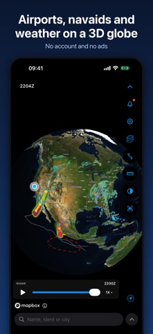
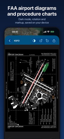
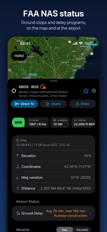
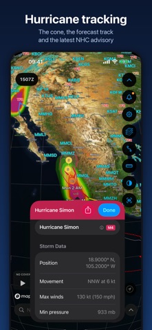
AeroPointer shows airports, navaids, and aviation weather on a 3D globe, with FAA charts at every US airport. No account needed, no ads, and no tracking. Version 4.2 adds AeroPointer Pro, an optional subscription. The free version keeps everything AeroPointer always had, plus improved and new features. Pro adds deeper weather layers, forecasts, route editing, and more. ON THE MAP • A 3D globe or a flat map, with Standard, Streets and Satellite base layers and a dark theme • Animated US radar with a timeline you can scrub • US infrared satellite • TFRs, AIRMETs and SIGMETs drawn and labeled on the map • Flight category for every reporting station: VFR, MVFR, IFR or LIFR • FAA airport status showing ground stops and delays • Hurricane tracker with the forecast track, the cone, NHC wind probability and arrival times, and the areas of interest • Alerts behind the bell: your notifications, FAA NAS status and the active tropical storms • Runway layouts at close zoom • Tap anywhere for any location's coordinates and magnetic variation • A ruler tool for distance, bearing, and time between two points • A configurable Zulu/local clock AT THE AIRPORT • METAR and TAF, raw or decoded, color coded, with the age of every report • D-ATIS (for supported airports) • Runway wind components from the current METAR • NOTAMs, decoded or raw, grouped and searchable • FAA NAS status: ground stops, ground delay programs and closures • FAA airport diagrams and instrument procedure charts for US airports, with dark mode, rotation and markup • Runways, frequencies, fuel, VOT, elevation and magnetic variation • Local and Zulu time, sunrise, sunset and civil twilight WITH AEROPOINTER PRO • Lightning strikes on the map, with the last five minutes animated • Winds aloft and temperatures (surface to FL480) • Turbulence by altitude, now and up to 18 hours ahead • Pilot Reports (PIREPs) • Echo tops, European composite radar, global IR satellite, surface analysis (fronts and pressure areas), global surface temperature and smoke plums • A 10-day and hourly forecast at every airport, and the weather at any point you tap or any city you search • A route editor with airways, SIDs and STARs • Vertical profile view with winds, turbulence, icing, AIRMETs, SIGMETs and TFRs along your route • Direct To, saved routes and your own custom waypoints • The delay trend at supported airports • Offline chart pack management by state, kept up to date THE DATA • More than 50,000 airports and 9,500 navaids worldwide, with official FAA data for the US, and open source data from Ourairports.com for the rest of the world. • Airport and navaid data (VORs, DMEs, VOR/DMEs, NDBs, VORTACs and TACANs) is stored on your device and works without a connection • Weather, NOTAMs and charts you have opened stay available offline • Every weather layer shows its source and its age Built for pilots by an airline pilot and flight instructor. AeroPointer Pro is available as an annual plan with 14 days free, or a monthly plan. Payment is charged to your Apple ID account when you confirm your purchase or at the end of the free trial. The subscription renews automatically unless you cancel it at least 24 hours before the end of the current period. Manage or cancel it in your App Store account settings. AeroPointer is for general reference and supplemental awareness only. It should not be used as a primary source for flight planning or navigation. The data comes from third-party sources, both official and unofficial, including the FAA, NOAA, the National Weather Service, Apple Weather and ourairports.com. The data is not guaranteed to be accurate, current, or available at any given time. You are responsible for verifying flight information using official sources. Privacy Policy: https://www.pilotscafe.com/aeropointer/privacy-policy/ Terms of Use: https://www.apple.com/legal/internet-services/itunes/dev/stdeula/
What's new · 4.2
• AeroPointer Pro, an optional subscription. • Lightning strikes on the map • Winds aloft and turbulence by altitude • Choose the altitude for wind and temperature for any location on the globe. • Your route, with the weather along it • City weather in Favorites, Nearby and Recent • NHC wind probability on the Hurricanes layer: the chance of 34, 50 or 64 kt winds within 5 days • Arrival time of tropical storm winds on the Hurricanes layer, earliest reasonable or most likely • A comprehensive User Manual, in Settings • All alerts now live in one place, under the bell icon: app notifications, NAS status, and active storms
Details