

Altitude measurement
Nanshu Kaneshiro · Navigation
Independent analytics for this App Store listing. AppTracker is not affiliated with Nanshu Kaneshiro.
Chart standing · US
What changed · US
Listing changes AppTracker has observed for this app in this storefront — new versions, price moves, rating shifts, and store copy.
Altitude Measurement has been rebuilt from the ground up. - Rebuilt, with faster and more accurate elevation at the map crosshair - In Japan, uses high-precision data from the Geospatial Information Authority of Japan (down to a 1 m mesh) - New Disaster layers: flood, inland flooding, storm surge, tsunami, landslide and flood-duration hazard maps on the map - New Shinsui Navi: see the maximum flood depth and time until flooding if a nearby river breaks its banks - Now supports iPad, with a sidebar layout for larger screens - Now available on Mac too, as the same app on the Mac App Store - Favorites sync through iCloud - Dark Mode, larger text and VoiceOver support - 14 languages - Existing altitude:// links keep working - The earlier "elevation at five points along a line" feature is not included in this version - Free to use (shows an ad at the bottom of the screen)
Ratings breakdown · US
The star breakdown behind this app's rating in this storefront.
In-app purchases · US
No in-app purchases.
Screenshots



About
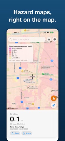
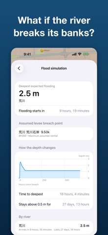
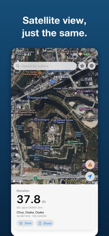
Altitude Measurement shows the ground elevation of the spot under the map crosshair, instantly. In Japan, it also lets you see hazard maps and a flood simulation on the same map. ELEVATION AT A GLANCE - Move the map and the elevation under the crosshair updates - Japan uses high-precision data from the Geospatial Information Authority of Japan (down to a 1 m mesh); elsewhere it uses worldwide elevation data - Tap the location button to compare the ground elevation with the altitude your device measures - Switch between meters and feet - Search by address or place name; switch between standard and satellite maps DISASTER PREPAREDNESS (JAPAN) - Overlay hazard maps for river flooding, inland flooding, storm surge, tsunami, landslides and flood duration - Show up to two layers at once and adjust their opacity - A legend in the official colors always stays on the map - "Shinsui Navi" shows what could happen if a nearby river breaks its banks: maximum flood depth, time until flooding starts, and a graph of depth over time FAVORITES - Save places you use often, with their name and elevation - Sync them between your own iPhone, iPad and Mac through iCloud EASY TO USE - iPhone shows the map with a card; iPad adds a sidebar for a roomier layout - Supports Dark Mode, larger text and VoiceOver - 14 languages: Japanese, English, Korean, Chinese (Simplified and Traditional), German, French, Spanish, Italian, Portuguese (Brazil), Dutch, Polish, Turkish and Russian - Share an elevation, or open a place from a shortcut with an altitude:// link LOCATION AND PRIVACY Your location is used only when you tap the location button, never just because the app launched. To look up an elevation, the app sends only map tile numbers, not your exact position. ADS The app is free. To keep it running, it shows an ad at the bottom of the screen. In Settings you can watch a short video ad to the end and hide ads for the rest of the day. ■ Data sources Elevation: GSI elevation tiles (Japan); AWS Terrain Tiles elsewhere (USGS 3DEP, SRTM, GMTED2010, NOAA ETOPO1 and others) Hazard maps: Hazard Map Portal Site, Ministry of Land, Infrastructure, Transport and Tourism (GSI tiles) Shinsui Navi: GSI flood simulation Credits also appear in the in-app map legend, the disaster screen and Settings > Data Sources. ■ Please note - Elevations are reference values derived from public data such as the Geospatial Information Authority of Japan (GSI). Do not rely on this app alone for surveying, climbing or evacuation decisions. - Hazard maps and the flood simulation (Shinsui Navi) appear only in Japan. They show assumed scenarios, not a guarantee of actual damage. Check your local government and official national sources for the latest information. - No account or sign-in is required.
What's new · 2.0.0
Altitude Measurement has been rebuilt from the ground up. - Rebuilt, with faster and more accurate elevation at the map crosshair - In Japan, uses high-precision data from the Geospatial Information Authority of Japan (down to a 1 m mesh) - New Disaster layers: flood, inland flooding, storm surge, tsunami, landslide and flood-duration hazard maps on the map - New Shinsui Navi: see the maximum flood depth and time until flooding if a nearby river breaks its banks - Now supports iPad, with a sidebar layout for larger screens - Now available on Mac too, as the same app on the Mac App Store - Favorites sync through iCloud - Dark Mode, larger text and VoiceOver support - 14 languages - Existing altitude:// links keep working - The earlier "elevation at five points along a line" feature is not included in this version - Free to use (shows an ad at the bottom of the screen)
Details