

Mossback
William Lawrence · Navigation
Independent analytics for this App Store listing. AppTracker is not affiliated with William Lawrence.
Chart standing · US
What changed · US
Listing changes AppTracker has observed for this app in this storefront — new versions, price moves, rating shifts, and store copy.
Mossback is faster. The app opens quicker and hike pages and maps load sooner. Mossback now covers 32 areas, with 15 new national parks added, including Grand Canyon, Yosemite, Glacier, Grand Teton and Olympic. Each park has its hikes, trailheads and parking, and you can download the map to use with no signal. Weather now comes from Apple Weather, with an hourly forecast for the next twelve hours and weather alerts for where you are headed. Fishing is much better. Rivers show live water levels, and stocked trout streams show the latest stocking. Fish pages list advisories about which fish are safe to eat, and access points show where you can get to the water. Hike pages now show the drive time to the trailhead and the nearest parking, so you know how long the drive is and where to leave the car before you head out. Tell us if anything looks wrong, like a route in the wrong place or a trailhead that is not where the app says. Report a problem is on every hike page.
In-app purchases · US
No in-app purchases.
Screenshots



About
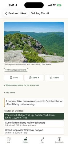
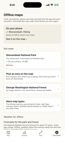
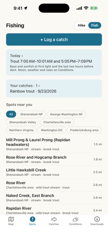
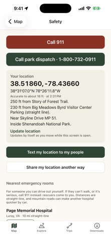
Mossback is a hiking and fishing planner that works without cell service, starting with Shenandoah National Park and the George Washington National Forest. Trails, hikes, parking, rules and elevation are built in, so it all still works when your signal drops at the trailhead. FIND EVERY HIKE • 339 hikes in the park, from Old Rag and Whiteoak Canyon to the loops, backpacking circuits and A.T. sections people actually do, plus all 372 named park trails • 244 hikes and 228 trails in the George Washington National Forest and along the Blue Ridge Parkway • Places with several routes, like Old Rag, show them side by side • Find a hike: waterfalls, views, summits, swimming holes, rock formations, caves, fire towers, history, springs, creeks and camping, plus loops, scrambles, quiet trails, dogs and kids • What's on this hike: every falls, view, cave and ruin along the way, and how far in BUILD MY HIKE • Pick what you want to see, like a waterfall, a view and a swimming hole, or places by name, and get real hikes on the trails from a real trailhead • Choose a loop or an out and back, a length like 5 to 10 miles, and a climb limit • Dogs with you? It keeps to the trails where dogs are allowed • Honest answers: if no one hike has it all, it says so and shows the closest ones • Plan an overnight, too: it finds a real hut, shelter, cabin or campground for the night and splits the miles between two days • See the climb on the map, then save it or start it • Good right now: this month's best hikes, and a heads-up when the streams are running high and the falls are at their best PLAN A HIKE YOU CAN FINISH • Plan your own hike: tap waypoints and the route follows the trails, with distance, climb and time • Search the map for over 800 places, from waterfalls and summits to caves, rock formations, old homesites and springs • "Can I finish before dark?" and door-to-door timing with Apple Maps drive time • Know before you go: the Old Rag ticket, closed trails, trails where dogs aren't allowed, busy trailheads, scrambles, hunting seasons and weather hazards • Water on the way, junctions you'll pass, best time of year, and a packing list from the forecast • Stars: when it's dark, where the moon is, and the best hours for a sunset hike or a night out • Save hikes, mark them done, earn badges, and see your next one on a home screen widget NAVIGATE ON THE TRAIL • Live navigation with your progress and a route picture on the lock screen • Off-course and turnaround alerts, plus the next water and next junction • Waypoints for campsites, water, views, cell signal and more, with your notes and photos STAY SAFE • Text your plan to your people in one tap, with when to call for help, and "back safe" when you're done • SOS card: coordinates, trail, nearest lot, milepost, ER and ranger office, updating as you move, all without signal FISHING MODE • 69 public spots around DC and the park's trout streams, each with its license and limits • Tides, live water temperature and Virginia trout stocking • Feeding windows, moon and solunar times, a monthly hatch chart, species ID, knots and eating advisories • Log every catch with the bait or lure that worked; see your trends RECORD AND LEARN • Record hikes with GPS, even locked, with a battery saver for long days • Share a picture, rate it, and watch your stats grow • Import and export GPX, and export all your data WORKS OFFLINE • Download the whole park, a district, your saved hikes, or a square on the map. See what's already downloaded; nothing downloads twice • Four map styles: Hiking, Topo, Satellite and USGS Topo • Everything but live weather, gauges, water temperature, stocking and hike photos is built in PRIVATE BY DESIGN • No account, no ads, no analytics, no tracking. Your data stays on your phone. Rules and safety information are for reference only. Always check current conditions and official sources. Mossback is not affiliated with the National Park Service or the U.S. Forest Service.
What's new · 1.2.0
Mossback is faster. The app opens quicker and hike pages and maps load sooner. Mossback now covers 32 areas, with 15 new national parks added, including Grand Canyon, Yosemite, Glacier, Grand Teton and Olympic. Each park has its hikes, trailheads and parking, and you can download the map to use with no signal. Weather now comes from Apple Weather, with an hourly forecast for the next twelve hours and weather alerts for where you are headed. Fishing is much better. Rivers show live water levels, and stocked trout streams show the latest stocking. Fish pages list advisories about which fish are safe to eat, and access points show where you can get to the water. Hike pages now show the drive time to the trailhead and the nearest parking, so you know how long the drive is and where to leave the car before you head out. Tell us if anything looks wrong, like a route in the wrong place or a trailhead that is not where the app says. Report a problem is on every hike page.
Details