

SimpleFlight Planner
Kip Haas · Navigation
Independent analytics for this App Store listing. AppTracker is not affiliated with Kip Haas.
Chart standing · US
What changed · US
Listing changes AppTracker has observed for this app in this storefront — new versions, price moves, rating shifts, and store copy.
• Route profile: terrain, airspace, cloud bases and freezing level along your route, with highest terrain and clearance at cruise. • Edit a planned flight from its profile: add a waypoint where the terrain is, drag it around, and re-plan. • Map ruler: hold two fingers on the map to measure distance, course, time and fuel. • Send to ForeFlight: open your route in ForeFlight Maps in one tap. • Re-planning a recent flight updates it instead of adding a copy. • New SimpleFlight wordmark.
Ratings breakdown · US
The star breakdown behind this app's rating in this storefront.
Screenshots




About
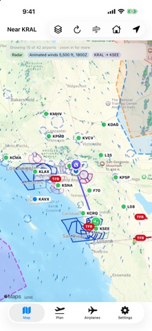
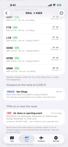
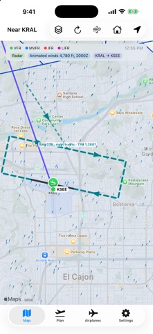
SimpleFlight answers the questions that matter before a VFR flight: how far, how long, how much fuel, what the weather is doing along the way, what airspace is in the way, and what the destination looks like when you get there. Built by a pilot, for the United States, for VFR. Saying no to everything else is what keeps it simple. PLAN • Pick a departure and destination. Press and hold the route line to bend it around airspace; it snaps to nearby airports, VORs and fixes. • Choose from legal VFR hemispheric altitudes, each with its headwind or tailwind and time en route from current winds aloft. • Get wind-corrected heading, groundspeed, time, fuel burn and reserve for your airplane. WEATHER • Decoded METARs and TAFs for reporting airports along the route, colored by flight category. • Animated winds at your cruise altitude, radar and satellite on the map. • Winds aloft table for 6, 12 and 24 hours. SIGMETs, G-AIRMETs and pilot reports in the corridor. ROUTE PROFILE • A side view of the route: terrain under it, your cruise altitude, Class B, C and D shelves, cloud bases from METARs and the freezing level. • Highest terrain on the route and your clearance at cruise, with a preview of every VFR altitude. • Edit the route from the profile: find the ridge, drop a waypoint there and drag it around, then re-plan in place. MAP RULER • Hold two fingers on the map to measure distance, magnetic course from each end, and no-wind time and fuel. AIRSPACE AND TFRs • Class B, C and D with floors and ceilings. Shelves that apply at your altitude stand out; the rest fade back. • TFRs on or near the route, checked against your planned time and altitude, with the NOTAM text a tap away. DESTINATION • Headwind and crosswind for every runway, with the favored runway marked. • A to-scale runway diagram and the expected traffic pattern, drawn on the map when you zoom in, with left or right traffic from FAA data and pattern altitude. • Frequencies, elevation, fuel, sunrise and sunset. SHARE • Send the route to ForeFlight or Garmin Pilot in one tap, or export a Garmin FPL file, waypoints included. YOUR DATA • No account needed. Without one, nothing you enter leaves your device. • Optional Sign in with Apple syncs your airplanes and plans between iPhone and iPad. Export or delete your account any time in Settings. • No ads. No tracking. IMPORTANT SimpleFlight is a planning aid. It is not an official weather or NOTAM briefing, it is not approved by the FAA, and it is not for navigation. Data can be late, incomplete or wrong. Terrain comes from USGS elevation data and does not include towers or other obstacles. Traffic patterns and runway diagrams are schematics; ATC instructions and published procedures take precedence. The pilot in command is responsible for every decision. Get an official briefing and check current charts before every flight. Data: Aviation Weather Center (NOAA), FAA, USGS, Iowa Environmental Mesonet, Open-Meteo.
What's new · 1.1.0
• Route profile: terrain, airspace, cloud bases and freezing level along your route, with highest terrain and clearance at cruise. • Edit a planned flight from its profile: add a waypoint where the terrain is, drag it around, and re-plan. • Map ruler: hold two fingers on the map to measure distance, course, time and fuel. • Send to ForeFlight: open your route in ForeFlight Maps in one tap. • Re-planning a recent flight updates it instead of adding a copy. • New SimpleFlight wordmark.
Details