

HuntEdge
EDDIE HOLLIS HENEGAR · Sports
Independent analytics for this App Store listing. AppTracker is not affiliated with EDDIE HOLLIS HENEGAR.
Chart standing · US
What changed · US
Listing changes AppTracker has observed for this app in this storefront — new versions, price moves, rating shifts, and store copy.
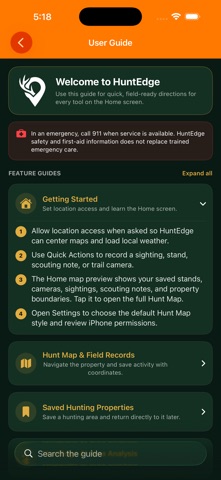
HuntEdge 1.3 improves your map and field-planning tools: • More reliable offline topo downloads and saved-area navigation. • Smoother map zooming and a scrollable Layers panel. • Animated NOAA weather radar and USGS bare-earth hillshade. • Deer and elk camera tools, updated animal icons, and shared hunting-property selection for Wildlife Movement and Rut Data. • A cleaner home screen, updated user guide, and backup-restoration fixes. Radar and hillshade require internet. Offline downloads apply to Topo maps. Property and public-land coverage varies; always verify boundaries, hunting access, and current agency rules.
In-app purchases · US
No in-app purchases.
Screenshots

Similar apps
Competitors and close alternatives, as estimated by AppTracker.
 HuntStand: GPS Maps & Tools
GSM Outdoors
HuntStand: GPS Maps & Tools
GSM Outdoors
 MyHunt: US Best Hunting App
Hunter & Companion Gesellschaft mit beschrankter Haftung
MyHunt: US Best Hunting App
Hunter & Companion Gesellschaft mit beschrankter Haftung
 GOHUNT: Research & Maps
GOHUNT, LLC
GOHUNT: Research & Maps
GOHUNT, LLC
 HuntWise: A Better Hunting App
Sportsman Tracker
HuntWise: A Better Hunting App
Sportsman Tracker
 HuntrMap: Maps, Wind, Weather
David Steinbrede
HuntrMap: Maps, Wind, Weather
David Steinbrede
 iHunt Journal
Michael Kircher
iHunt Journal
Michael Kircher
 DeerTrack
Robert Stevenson
DeerTrack
Robert Stevenson
 WeHunt: Hunting, Maps & Dogs
Natlink AB
WeHunt: Hunting, Maps & Dogs
Natlink AB
About
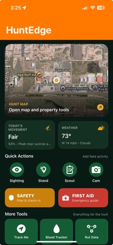
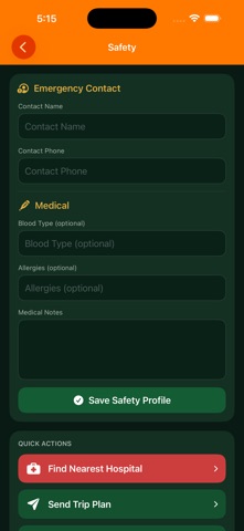
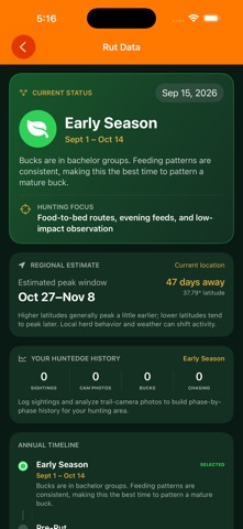
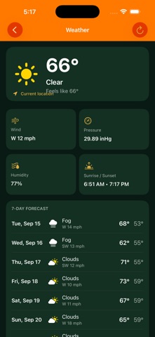
HuntEdge brings your hunting map, field observations, trail cameras, weather, and planning tools together in one field-ready app. Map and plan: - Standard, satellite, hybrid, and USGS topographic map styles - Deliberately downloaded offline topo areas - Tree stands, trail cameras, scouting notes, sightings, blood trails, and property boundaries where available - Public-land overlays and selected state hunting units; check official rules and access - Online USGS bare-earth hillshade and animated NOAA weather radar - Animated wind direction and stand-wind guidance - Track Me route recording with recovery drafts Understand deer and elk activity: - Current deer movement guidance, a three-day movement outlook, and 14-day movement history - Seven-day weather forecasts and deer and elk rut guidance - Weather, pressure, wind, moon, and rut information - Trail-camera photo-strip reading for date, time, and temperature - On-device deer and elk suggestions and camera pattern reports - HuntEdge AI analysis of the visible hunting area around a selected stand Keep field records: - Harvest log, gear locker, ballistics, safety plan, and first-aid guide - CSV exports and complete backup ZIPs - Backup restore with automatic pre-restore safety backup HuntEdge guidance and AI results are planning aids, not guarantees. Verify property boundaries, local regulations, weather, terrain, and field conditions. In an emergency, contact local emergency services.
What's new · 1.3
HuntEdge 1.3 improves your map and field-planning tools: • More reliable offline topo downloads and saved-area navigation. • Smoother map zooming and a scrollable Layers panel. • Animated NOAA weather radar and USGS bare-earth hillshade. • Deer and elk camera tools, updated animal icons, and shared hunting-property selection for Wildlife Movement and Rut Data. • A cleaner home screen, updated user guide, and backup-restoration fixes. Radar and hillshade require internet. Offline downloads apply to Topo maps. Property and public-land coverage varies; always verify boundaries, hunting access, and current agency rules.
Details