

SITE DIM
Jean-David Giroux · Business
Independent analytics for this App Store listing. AppTracker is not affiliated with Jean-David Giroux.
Chart standing · US
What changed · US
Listing changes AppTracker has observed for this app in this storefront — new versions, price moves, rating shifts, and store copy.
- Concrete takeoff: slabs, footings and pilasters are now measured exactly like a floor survey (square/rectangle, circle, half-moon or full trace), then a thickness — measured in AR or typed in manually. - New top-down slab plans: every side is dimensioned and the total area shows right on the plan. - Survey summary and concrete order: PDF export redesigned as a clear, line-by-line list, easy to read when printed. - Corner squaring (90°/180°) now available on terrain surveys and on a concrete slab's full trace. - Improved on-screen markers while measuring, across every survey type. - Stability and accuracy fixes.
Screenshots




About
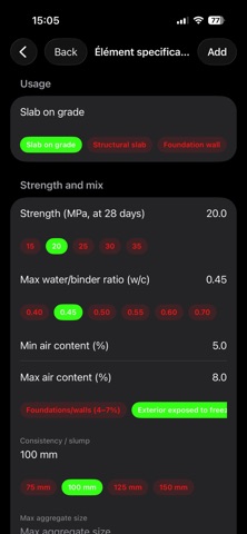
SITE DIM — LiDAR Site Survey & Takeoff Measure walls, floors, ceilings, roofs, linear runs and lots right on the job site using your iPhone or iPad's camera and LiDAR — no tape measure, no manual math. SURFACE SURVEYS Walls, floors and ceilings: aim at each corner in augmented reality, and the app computes distances, net area (with openings subtracted) and perimeter in real time. Four capture modes: square/rectangle, circle, half-moon, or full trace for an irregular shape. ROOF Measure slope and façade as independent segments (handy for a run interrupted by a dormer) — never an auto-estimated slope. LINEAR MEASUREMENTS Baseboards, mouldings: length and height at a glance. LOT / TERRAIN Trace a lot's perimeter, add excavation and up to 3 sequential fill layers, with volume computed by real triangulation or by layer depending on the mode. LIDAR ROOM SCAN One RoomPlan scan captures a room's walls, floor and ceiling at once. CONCRETE TAKEOFF Slabs, footings, pilasters and foundation walls: measure an area (just like a floor survey) or a length, add the thickness, get the required volume instantly. Compile a complete order (strength, slump, admixtures, delivery) to send straight to your supplier. ACCURACY Position computed once, locked for good — no drift. Automatic preference for the LiDAR mesh for the best precision your device can offer. EXPORTS Plan view (PNG, vector DXF), full-page PDF survey summary table, complete concrete order — all in feet-inches or metric, your choice. Built for general and specialty contractors who need fast, accurate, professional site surveys, right where the work happens.
What's new · 1.4.2
- Concrete takeoff: slabs, footings and pilasters are now measured exactly like a floor survey (square/rectangle, circle, half-moon or full trace), then a thickness — measured in AR or typed in manually. - New top-down slab plans: every side is dimensioned and the total area shows right on the plan. - Survey summary and concrete order: PDF export redesigned as a clear, line-by-line list, easy to read when printed. - Corner squaring (90°/180°) now available on terrain surveys and on a concrete slab's full trace. - Improved on-screen markers while measuring, across every survey type. - Stability and accuracy fixes.
Details