

NOTAM Briefer
amenai technologies · Navigation
Independent analytics for this App Store listing. AppTracker is not affiliated with amenai technologies.
Chart standing · US
What changed · US
Listing changes AppTracker has observed for this app in this storefront — new versions, price moves, rating shifts, and store copy.
What's new in 1.1 • Airport layouts on the map: runways, taxiways and aprons appear when you zoom in close. • Sharper maps: past the VFR chart's detail, the map switches to a street map instead of a blurry chart. • New briefing filter, with presets for your aircraft type. • In flight: one tap closes a NOTAM and returns to the map, with larger controls. • Easier-to-read map labels, with ICAO and French chart codes. • Crowded spots on the map open cleanly, as a fan or as a list. • New navy look.
Ratings breakdown · US
The star breakdown behind this app's rating in this storefront.
Screenshots




About
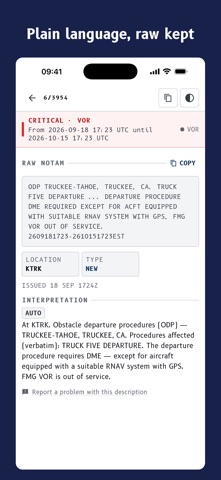
NOTAM Briefer turns raw NOTAM teletype into something you can read, for the airports and the route you are actually flying. BRIEF A WHOLE FLIGHT IN ONE PASS Enter departure, destination and alternates. You get every NOTAM for those aerodromes plus the corridor between them, grouped in flight order and sorted by severity, so what matters is at the top. RAW TEXT FIRST, PLAIN LANGUAGE UNDERNEATH The published teletype is what you are accountable for having read, so it leads. A plain language reading in English or French follows it, clearly marked as machine generated. You can flip the order in Settings. SEE IT ON THE CHART Every NOTAM draws on a visual flight rules chart: affected areas, route lines, severity and category colours, filters, and a tap for the full record. Day, night, and a red night theme. LIVE TRACKING WHILE YOU FLY Turn on tracking and the app watches for NOTAMs near the aircraft. Your position shows on the chart, north up or track up, and you are told when you enter or leave an affected area. WORKS WITHOUT A SIGNAL Tracking is used where there is no network, so while the app is open it keeps the chart and the NOTAM data around the aircraft downloaded: 50 nautical miles at high detail, 150 nautical miles around that. When the signal drops, tracking keeps answering from what is stored and tells you how old it is. Briefings you have opened stay readable offline. Storage stays under 150 MB. TAKE IT WITH YOU Export any briefing as a PDF to share, print or save. Each section carries a map of its own NOTAMs, and the document builds on the device, so it works offline. ALSO IN THE APP Voice entry for airport codes, using standard phonetics in English or French. Saved routes for the legs you fly often. Full support for the system text size, including the largest accessibility settings. English and French throughout. IMPORTANT This service is not approved for flight preparation or navigation, and its data may be incomplete or delayed. Plain language readings are automated and may be wrong. The raw NOTAM text is the sole source of truth. Terms of Use (EULA): https://www.apple.com/legal/internet-services/itunes/dev/stdeula/
What's new · 1.1
What's new in 1.1 • Airport layouts on the map: runways, taxiways and aprons appear when you zoom in close. • Sharper maps: past the VFR chart's detail, the map switches to a street map instead of a blurry chart. • New briefing filter, with presets for your aircraft type. • In flight: one tap closes a NOTAM and returns to the map, with larger controls. • Easier-to-read map labels, with ICAO and French chart codes. • Crowded spots on the map open cleanly, as a fan or as a list. • New navy look.
Details