

Mil GPS - MGRS & UTM Map
Yigit Ozkan · Navigation
Independent analytics for this App Store listing. AppTracker is not affiliated with Yigit Ozkan.
Chart standing · US
What changed · US
Listing changes AppTracker has observed for this app in this storefront — new versions, price moves, rating shifts, and store copy.
Performance improvements and bug fixes for smoother navigation and mapping.
Screenshots



Similar apps
Competitors and close alternatives, as estimated by AppTracker.
 MilGPS
Cascode Labs Pty Ltd
MilGPS
Cascode Labs Pty Ltd
 Tactical GPS - MGRS Land Nav
Ivan Blajic
Tactical GPS - MGRS Land Nav
Ivan Blajic
 MilGPS+
mustafa pistofoglu
MilGPS+
mustafa pistofoglu
 TerraGrid: MGRS Tactical GPS
Enes Furkan Bayram
TerraGrid: MGRS Tactical GPS
Enes Furkan Bayram
 Tactical MAP PRO : Navigation
mustafa pistofoglu
Tactical MAP PRO : Navigation
mustafa pistofoglu
 Alpin Quest PRO – Outdoor GPS
mustafa pistofoglu
Alpin Quest PRO – Outdoor GPS
mustafa pistofoglu
 MGRS GPS: Grid & Land Nav
Dajiale
MGRS GPS: Grid & Land Nav
Dajiale
 MilGPS PRO
mustafa pistofoglu
MilGPS PRO
mustafa pistofoglu
About
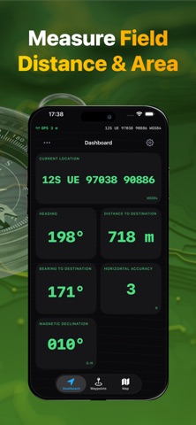
Mil GPS - MGRS & UTM Map is your ultimate tactical land navigation assistant, built for professionals, military personnel, and outdoor enthusiasts. Whether you are navigating off-grid terrain, planning a tactical route, or managing complex field operations, this app transforms your device into an advanced geo and topo mapping tool. Advanced Tactical Navigation: - Real-Time Coordinates: Instantly display your exact location and map crosshairs in MGRS, UTM, DMS, and Lat/Lon formats. - Offline Topo Maps: Download comprehensive topographic, satellite, and terrain maps for reliable land navigation when you are completely off the grid. Never lose your way without a cellular signal. - Tactical Route Planning: Draw custom routes, track your live path, and project waypoints. Engineered for fast, reliable tactical nav (tacnav) and field operations. - Precision Waypoints & Grid: Drop, edit, and manage essential waypoints. Customize them with tactical icons, names, and field notes. Export and import easily via GPX or KML formats. - Distance & Area Measurement: Instantly calculate field distance between multiple points, target bearing, and land perimeters directly on the active map. - Pro Compass Assistant: High-accuracy digital compass featuring target bearing, current heading, magnetic declination, and exact distance to your destination. Supported Coordinate Systems & Datums Designed to match military specifications and professional mapping standards, our coordinate engine supports a wide array of formats essential for global operations: - WGS84, ED50, NAD27, NAD83, OSGB36 - MGRS (Military Grid Reference System) - UTM (Universal Transverse Mercator) - DMS (Degrees, Minutes, Seconds) - USNG (United States National Grid) Built for the Field: This tool is a fast, battery-efficient alternative to bulky tactical systems, perfectly optimized for: -Military personnel and tactical operators requiring precise grid references. -Search and Rescue (SAR) teams and first responders. -Hunters, hikers, and off-road explorers demanding reliable off-grid GPS trackers and offline maps. -Land surveyors, geo-caching enthusiasts, and professional navigators. SUBSCRIPTION Mil GPS - MGRS & UTM Map offers an optional auto-renewing subscription that unlocks all features. Prices are shown in the app before purchase, in your local currency. - Payment is charged to your Apple ID account at confirmation of purchase. - Subscriptions renew automatically unless auto-renew is turned off at least 24 hours before the end of the current period. - Your account is charged for renewal within 24 hours prior to the end of the current period. - If a free trial is offered, any unused portion is forfeited when you purchase a subscription. - You can manage or cancel your subscription in your Apple ID Account Settings after purchase. Terms of Use: https://hengames.co/app/terms/ Privacy Policy: https://hengames.co/app/privacy/
What's new · 1.0.1
Performance improvements and bug fixes for smoother navigation and mapping.
Details