

Helm Boating: GPS, Chart & Map
LOOP MOBILE FZCO · Navigation
Independent analytics for this App Store listing. AppTracker is not affiliated with LOOP MOBILE FZCO.
Chart standing · US
What changed · US
Listing changes AppTracker has observed for this app in this storefront — new versions, price moves, rating shifts, and store copy.
- Fixed a crash that could happen while planning a route - Charts with routing no longer freeze the app for several seconds when they open - Fixed routes that could not be planned in some areas because the chart grid failed to load - Warns you when the phone does not have enough storage for a chart pack - If the app is closed during a trip, you can resume it and the track is kept in your logbook - Clearer messages when there is no GPS fix yet or a route starts on land
Screenshots




About
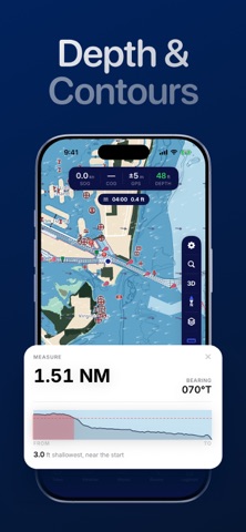
Helm is a US marine navigation app for boaters who run shallow, unfamiliar or poorly charted water and want to know what is under the hull before they get there. YOUR DRAFT IS PART OF THE CHART Enter your boat's draft once. Helm shades the water you cannot safely cross and plans routes around it, instead of drawing a straight line through a two-foot shoal. DEPTH AGAINST YOUR DRAFT Helm reads depth from NOAA electronic navigational charts on the coast and the Great Lakes, and from the US Army Corps of Engineers Inland ENC on the rivers. Where a NOAA tide station is close enough, it adds the predicted tide and tells you whether that leaves enough water under your keel. TIDES AND CURRENTS Tide predictions come from NOAA CO-OPS against the MLLW datum. Tidal current arrows rotate with the time you scrub to, so you can see whether you will be pushed or held back before you commit to a pass. WEATHER YOU CAN READ AT A GLANCE Animated wind, wave and current overlays on the chart. A multi-day strip with three-hour columns for wind, gusts, air temperature and rain, plus water temperature where data exists. Outside US waters the forecast falls back to a global model so the app still works. OFFLINE FIRST Coverage is packaged into downloadable chart packs. Take the ones you need and leave the rest. Once a pack is on the device, the chart, depth and the anchor alarm keep working with no cell service, and so does routing in the coastal and Great Lakes regions. That is the point on open water. WHILE YOU ARE UNDERWAY - Depth, speed over ground and course over ground on one strip - Anchor alarm that wakes you if you drag - Nearby vessels on AIS - Satellite and night chart styles - Trips you run recorded to a logbook you can replay QUESTIONS PEOPLE ASK Does it work without cell signal? Yes. Download the chart packs for your area first and the app keeps working offline, including depth, the anchor alarm and routing in the coastal and Great Lakes regions. Is it only for the ocean? No. Coastal water, the intracoastal, the Great Lakes and the major commercial rivers are charted, and the lakes in every state are on the map by name and shoreline. What makes it different from other chart apps? Most of them render a chart and leave the depth judgement to you. Helm knows your draft, reads the charted depth against it with the predicted tide, and plans around water that is too thin for your boat. Does it work on iPad? Yes, natively — a real iPad layout rather than a stretched phone screen. Can I use it for fishing? Yes. Save spots, read the depth contours around them and return to the same place later from your recorded trips. Is it good for a small boat? That is the case it was built for. Small boats in shallow water are where a generic chart app is least useful and where knowing your draft matters most. Helm is built by Loop Mobile FZCO. Privacy Policy: https://loopmobile.io/privacy.html Terms of Use: https://loopmobile.io/tos.html
What's new · 1.0.3
- Fixed a crash that could happen while planning a route - Charts with routing no longer freeze the app for several seconds when they open - Fixed routes that could not be planned in some areas because the chart grid failed to load - Warns you when the phone does not have enough storage for a chart pack - If the app is closed during a trip, you can resume it and the track is kept in your logbook - Clearer messages when there is no GPS fix yet or a route starts on land
Details