

USGS River Levels & Flows
Verona Solutions, LLC · Weather
Independent analytics for this App Store listing. AppTracker is not affiliated with Verona Solutions, LLC.
Chart standing · US
What changed · US
Listing changes AppTracker has observed for this app in this storefront — new versions, price moves, rating shifts, and store copy.
River Levels Pro: one purchase removes the ads and adds a home screen widget, a "which of my rivers today" ranking, a logbook pinned to the chart, gauge-to-gauge and year-over-year comparison, where today sits against 30 years of record, run sheets you can share as a link or QR code, offline map packs, and CSV export. Everything that was free stays free: forecasts, history, seasonal normals, flood stages and offline readings.
In-app purchases · US
What this app sells inside itself, grouped by kind and priced for this storefront.
Screenshots



About
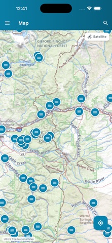
Check any river in the United States — flow, stage, and the National Weather Service forecast — from more than 10,000 official USGS gauges. Built for the people who actually need the number: paddlers deciding whether a run is in, anglers reading a rise, and anyone who lives where a creek can come up overnight. WORKS WHERE RIVERS ARE Rivers are where cell signal isn't. Every gauge you star is saved to your phone, so the put-in with no bars still shows your last reading — clearly labelled with its age, never passed off as live. The entire 10,000-gauge catalogue is bundled in the app, so search and browse work with the radio off. FREE, INCLUDING THE PARTS OTHERS CHARGE FOR • NOAA forecasts — the predicted hydrograph, drawn on the same chart as the observations, up to five days out • Years of history — 7 days, 30 days, 1 year or 5 years on any gauge • Seasonal normals — what this river typically does in each month, so you know whether today's number is high, low, or ordinary for the season • Flood categories — action, minor, moderate and major stages as published by the National Weather Service No account. No subscription. No paywalled forecasts. RIVER LEVELS PRO — ONE PURCHASE, YOURS FOR GOOD Everything above stays free. One optional purchase removes the ads and adds the tools built on top of the data: • Home screen widget — your gauges, their readings and your range status • "Which of my rivers today" — every favourite ranked by whether it is in your range, nearest first • Logbook — a note and a photo pinned to a gauge at the reading you saw, drawn on the chart • Compare two gauges on one chart, and this year against last year • Today vs. the record — where today sits against up to 30 years for this date • Run sheets — group a put-in, a takeout and a tributary under one run with a combined go/no-go, and share it as a link or QR code • Offline map packs — download the USGS topo or satellite map around a run • Copy your ranges between gauges, export any chart as CSV, launcher shortcuts WHAT YOU GET • 10,000+ USGS gauges across all 50 states and territories • Flow (ft³/s) and stage (ft), with the axis a station actually records • Observed and forecast on one chart, with flood stages shaded • Your own thresholds — set the range that means "runnable" or "too high" for your river, and see at a glance whether today is in it • Favourites with current readings for every gauge, at a glance • Map view — find gauges by looking, on USGS topo or satellite basemaps • Nearby gauges by GPS, and browse by state sorted A–Z or by distance • Dark mode HONEST ABOUT THE DATA Readings come straight from the U.S. Geological Survey and NOAA's National Water Prediction Service. Both are public-domain federal sources, and this app adds nothing to them but the reading. Gauge data can be delayed, provisional, or wrong, and rivers are dangerous. Nothing here is a substitute for looking at the water, local knowledge, or an official flood warning. Never make a safety decision from a number on a phone alone. PRIVACY No account, no sign-in, no tracking of where you go. Location is optional and requested only when you tap "Near me" or the map's locate button — the app is fully usable without ever granting it. Your favourites and thresholds stay on your device. Supported by ads, which River Levels Pro removes. Data courtesy of the U.S. Geological Survey and NOAA's National Water Prediction Service. Not affiliated with or endorsed by either agency.
What's new · 1.1.0
River Levels Pro: one purchase removes the ads and adds a home screen widget, a "which of my rivers today" ranking, a logbook pinned to the chart, gauge-to-gauge and year-over-year comparison, where today sits against 30 years of record, run sheets you can share as a link or QR code, offline map packs, and CSV export. Everything that was free stays free: forecasts, history, seasonal normals, flood stages and offline readings.
Details