

The Outdoors App
Outdoors Company LLC · Navigation
Independent analytics for this App Store listing. AppTracker is not affiliated with Outdoors Company LLC.
Chart standing · US
What changed · US
Listing changes AppTracker has observed for this app in this storefront — new versions, price moves, rating shifts, and store copy.
Save whole maps for use without signal. Download any map — your own, one shared with you, or a thru-hike like the Pacific Crest Trail — and it comes with you: the map itself, every waypoint and place, their details and photos. It opens, searches and exports with no signal at all. Long trails are sized for your phone. The whole route is saved at trail detail, and you choose the sections you want at full detail — the next hundred miles, or from one mile marker to another. You can see exactly what is saved: the saved area is shaded on the map, and the app tells you if you walk outside it. Downloads pause and pick up where they left off, and the app checks your phone has room before it starts. One Maps tab for everyone: your maps, maps shared with you, every thru-hike and the starter templates.
Price & rating history · US
Reconstructed from the listing changes AppTracker has observed in this storefront. A field is charted once it has changed more than once, and each line starts at the value it moved from.
Average rating · ★ 0.00 now · 4 changes on record
Ratings breakdown · US
The star breakdown behind this app's rating in this storefront.
Screenshots


About
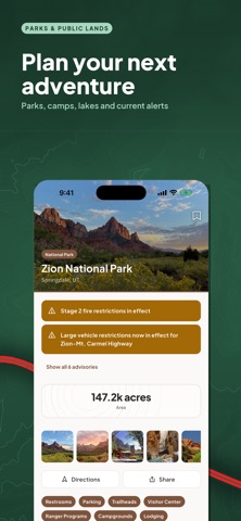
Plan your next adventure. The Outdoors App helps you get outdoors with confidence. Trails, campgrounds, campsites and parks across the United States — reservable sites and free dispersed camping alike — with 3D maps, offline maps and every detail you need in one place. FIND YOUR NEXT TRAIL Search more than 148,000 trails, from an hour's walk to a week in the backcountry. Filter by length, elevation gain, difficulty, dogs allowed and accessibility, and see what is genuinely near you. CAMPGROUNDS AND CAMPSITES, ESTABLISHED AND DISPERSED More than 48,000 campgrounds, from reservable sites in national and state parks to more than 21,000 free dispersed spots on public land. Go down to the individual campsite: tent or RV, hookups, price per night, maximum vehicle length, how many people it sleeps, shade, pets, water and cell coverage, with photos. Search for open sites near you, and if a campground is full, get an email when a cancellation frees one up. KNOW BEFORE YOU GO Distance, climb, an estimated time and an elevation profile. Permits, seasons and current conditions. Photos and reviews from people who were there. And a link to the managing agency's own page, with a clear note of where each piece of information comes from and when we last checked it — so you know how far to trust it. SEE THE TERRAIN IN 3D Tilt the map and see the climb before you commit to it. Topographic maps with contour lines, hillshade and trail paths, plus layers for weather radar, weather alerts and wildfire perimeters. MAPS THAT WORK WITHOUT SIGNAL Download whole trails, campgrounds and map regions before you go. Terrain, contours, trail paths and campsite details stay on your phone, so everything still works in the canyon where your phone does not. RECORD AND FOLLOW YOUR ROUTE Record your hike with the phone in your pocket and the screen off. Start from a trail page and the app shows how far along you are, the climb still ahead, and when you have wandered off the route. THRU-HIKE MAPS Curated maps of America's long trails — the Pacific Crest, the Appalachian, the John Muir and more. Termini, permits and the usual season, with every water source, resupply town, ranger station and bailout listed and searchable. NATIONAL AND STATE PARKS More than 10,000 parks, with contacts, the agency's own page and what is nearby. BUILD YOUR OWN MAPS Drop markers, draw areas, add photos and notes. Bookmark the places you want to go, and check the forecast on every trail and campground page. BUILT TO BE READ OUTSIDE High-contrast type, readable in daylight on a dimmed screen, and a dark mode for the tent. — — — Location is used to show what is nearby and to centre the map. Decline it and the app still works. Background location is used only while a recording you started is running. No ads. No tracking. We do not sell your data. Privacy policy: https://theoutdoorsapp.com/privacy
What's new · 1.3.0
Save whole maps for use without signal. Download any map — your own, one shared with you, or a thru-hike like the Pacific Crest Trail — and it comes with you: the map itself, every waypoint and place, their details and photos. It opens, searches and exports with no signal at all. Long trails are sized for your phone. The whole route is saved at trail detail, and you choose the sections you want at full detail — the next hundred miles, or from one mile marker to another. You can see exactly what is saved: the saved area is shaded on the map, and the app tells you if you walk outside it. Downloads pause and pick up where they left off, and the app checks your phone has room before it starts. One Maps tab for everyone: your maps, maps shared with you, every thru-hike and the starter templates.
Details