

Merestone: SSSI & Habitat Map
LEON NELIO FIGUEIRA · Reference
Independent analytics for this App Store listing. AppTracker is not affiliated with LEON NELIO FIGUEIRA.
Chart standing · US
What changed · US
Listing changes AppTracker has observed for this app in this storefront — new versions, price moves, rating shifts, and store copy.
British Columbia, Canada: 29 provincial and federal layers covering protected areas, habitats, waters, species records and critical habitat. BC Parks and CPCAD protected areas stay free. BC Albers and NAD83 UTM coordinate search, five presets and dated PDFs with source context. Coverage is limited to BC; public records do not establish presence or absence on site or replace field assessment and other required checks. Finland, including Åland: 155 map representations covering protected areas, habitats, water, heritage, planning, flood scenarios and public species observations. Mainland and Åland Natura 2000 SAC and SPA layers stay free. Search with ETRS-TM35FIN and export dated PDF reports with sources. Coverage and search eligibility vary by layer; observations do not establish presence or absence at your site.
In-app purchases · US
What this app sells inside itself, grouped by kind and priced for this storefront.
Screenshots



About
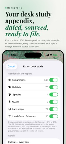
Environmental map searches and sourced PDFs. Not a survey or a LERC search. CANADA: BRITISH COLUMBIA ONLY 29 layers; BC Parks and CPCAD protected areas are free. ON THE MAP, UK • SSSI in England, Scotland and Wales, with unit condition and Impact Risk Zones in England • SAC, SPA and Ramsar across the UK, ASSI in Northern Ireland, nature reserves, National Parks, AONB, National Scenic Areas in Scotland, CRoW access land in England and Wales • Ancient woodland in England, Scotland and Wales; the Priority Habitats Inventory in England, priority habitats in Northern Ireland, Phase 1 in Wales • Scheduled monuments, listed buildings, parks and gardens, World Heritage Sites; battlefields except in Wales; Historic Marine Protected Areas in Scotland • Flood Zones 2 and 3 in England and Wales, SEPA flood likelihood in Scotland, also with climate change • Coastal erosion to 2105 and shoreline management plans in England • Nutrient neutrality, LNRS and the BNG register in England, ALC in England and Wales, Scottish conservation areas • Green Belt, TPOs, brownfield land and English conservation areas from planning.data.gov.uk are partial: empty is never proof of absence • The Scottish Wetland Inventory draws on the map and can be downloaded, but is outside the radius search and PDF results IRELAND From NPWS, the EPA, GSI, the National Monuments Service, Tailte Éireann and DHLGH: SAC, SPA, NHA and pNHA, parks and reserves, Ramsar, water, geology, archaeology, townlands and trails. Generalised Zoning Types from MyPlan complement the local authority's adopted development plan; they do not replace it. OPW national flood maps and GSI groundwater flood maps remain excluded pending permission. The RPS and ACAs are not included. SEARCH AND PDF Search eligible layers from 250 m to 20 km, by distance to the nearest edge. OS National Grid in Great Britain; ITM in Northern Ireland and Ireland. The PDF lists records with distance, direction, source and available source date, then empty or unsearched layers and why. The location plan needs a connection; without one, the PDF omits it. Publisher services, cached answers and downloaded copies can all supply data. Download eligible layers before fieldwork; reports identify downloaded data. Map-image and GBIF layers cannot be downloaded or listed by radius. The BNG register is a dated snapshot built into the app. EUROPE Also covers France, Belgium, Germany, Switzerland, the Netherlands, Norway, Sweden, Austria, Luxembourg, Italy, Spain, Portugal, Poland and Finland, each on its own grid. Coverage varies. Country pages list gaps and exclusions. Swiss layers work online only in this app. Luxembourg's PAG layers remain locked while their licence is clarified. SPECIES RECORDS Open-licence GBIF observations, CC0 and CC BY only, at most 300 per view: a first look, never an inventory or evidence of absence. They are outside the radius search and PDF results and cannot be downloaded. BUYING Buy a country once on this Apple Account, or a bundle, with no renewal. Or subscribe to every country, including any added later. Purchases cover iPhone, iPad, Mac and Watch. An optional account links purchases to merestonemaps.com. Free: the UK statutory core and a starter selection elsewhere, with a 250 m search. Free layers remain available without a purchase. PDF export and eligible offline downloads require the purchase or subscription. DATA AND LIMITS Layer sources and licences appear in the report. Not included: Local Wildlife Sites, Northern Ireland flood mapping, public rights of way, Scottish Core Paths or BGS geology. Confirm the official record before professional reliance. TERMS OF USE https://www.apple.com/legal/internet-services/itunes/dev/stdeula/ Privacy policy: https://leonfigueira.github.io/fieldmark-site/privacy.html
What's new · 2.8.0
British Columbia, Canada: 29 provincial and federal layers covering protected areas, habitats, waters, species records and critical habitat. BC Parks and CPCAD protected areas stay free. BC Albers and NAD83 UTM coordinate search, five presets and dated PDFs with source context. Coverage is limited to BC; public records do not establish presence or absence on site or replace field assessment and other required checks. Finland, including Åland: 155 map representations covering protected areas, habitats, water, heritage, planning, flood scenarios and public species observations. Mainland and Åland Natura 2000 SAC and SPA layers stay free. Search with ETRS-TM35FIN and export dated PDF reports with sources. Coverage and search eligibility vary by layer; observations do not establish presence or absence at your site.
Details