

METAR TAF 3D
Serkan arslan · Weather
Independent analytics for this App Store listing. AppTracker is not affiliated with Serkan arslan.
Chart standing · US
What changed · US
Listing changes AppTracker has observed for this app in this storefront — new versions, price moves, rating shifts, and store copy.
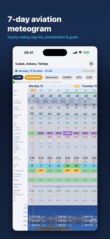
Alerts even when the app is closed, a new map and the weekly meteogram as PDF ALERTS — now from our server, even when the app is closed • TAF period alerts: the relevant period highlighted, the next period and the full raw TAF; choose the lead time in Settings • METAR and SPECI alerts; TAF AMD notifications • For favourite airports and saved map places: TS, RA, GR, SH, FG, wind/gusts, VFR/IFR changes, QNH drops, temperature and pressure • Weather alerts for your location (1 per day on the free plan) MAP • Live precipitation radar with a playback bar; stays sharp when zooming • SIGMETs and CTR/TMA/FIR airspace with bold lines • Rain, snow, lightning and fog animations over airports, based on the METAR • Tap an airport for a METAR + TAF card; tap any place to save it as a named favourite • Favourites shown with their names, my-location button, topo basemap • Adjust the opacity of each layer separately METEOGRAM • Hourly changing ceiling, hourly precipitation amount and type • Day and time stay visible while scrolling; faster drawing • Export the weekly meteogram with every chart as a PDF TRENDS & 3D • Detailed trend analysis for every period, consistent charts and an "Expected" outlook • Realistic rain, snow crystals, hail, lightning and fog in the 3D cloud profile; precipitation falls from the CB base MORE • QNH converter in Settings (hPa ↔ inHg) • New launch screen, translation and theme fixes
In-app purchases · US
What this app sells inside itself, grouped by kind and priced for this storefront.
Screenshots




About
Read a METAR at a glance — then see it. METAR TAF 3D turns raw aviation weather into a picture: an animated 3D cloud profile with the real ceiling, visibility and precipitation for the airport you are flying to, plus a 14-day meteogram built for pilots rather than for the general public. SEE THE SKY, NOT A STRING OF CODE • Animated 3D cloud profile — layers at their true heights, live rain and snow • Ceiling and visibility marked where they actually are • Day and night rendering that follows the sun at that airport • Active runway and wind indicator on the ground band EVERY CODE EXPLAINED, WITH ITS SOURCE • Tap any code in a raw METAR or TAF for a plain-language explanation • 128 codes covering the international ICAO format plus the national remark sections most pilots never learn: US RMK groups, Canadian cloud-type remarks, UK and NATO colour states • Every definition is cited to the document it comes from — FAA AC 00-45H, WMO No. 306, the NWS ASOS User's Guide, MANOBS — with a link to the original • Searchable glossary grouped by country A METEOGRAM BUILT FOR PILOTS • 14 days of fog risk, ceiling, visibility, temperature/dew point spread • Turbulence and icing bands, freezing level, density altitude • Winds aloft from the surface to FL300 • Crosswind for the active runway, hour by hour • Multiple forecast models side by side — ECMWF, GFS, ICON, GEM — and a consensus blend FULL PRE-FLIGHT PICTURE • Decoded METAR and TAF with BASE, TEMPO and BECMG periods • Aviation briefing: flight category, QNH, density altitude, winds aloft • NOTAMs and PIREPs • Weather map with flight-category colouring and a model wind rose • Runway compass with crosswind and headwind components • Worst-weather scan across your airports • Notes with freehand drawing, favourites, home-screen widget • Spoken briefing in nine languages BUILT ON OFFICIAL DATA Observations and forecasts come from NOAA/NWS and Open-Meteo. Runway data comes from published aerodrome records. Nothing in the decoder is guessed: where a code could not be verified against an official document, it is left out rather than invented. Nine languages: English, Turkish, German, Spanish, Italian, Japanese, Russian, Chinese, Malay. METAR TAF 3D is a situational-awareness aid. It is not a substitute for an official weather briefing or for the pilot-in-command's judgement. Terms of Use (EULA): https://www.apple.com/legal/internet-services/itunes/dev/stdeula/ Privacy Policy: https://www.kalyndatech.com/privacy
What's new · 3.8.0
Alerts even when the app is closed, a new map and the weekly meteogram as PDF ALERTS — now from our server, even when the app is closed • TAF period alerts: the relevant period highlighted, the next period and the full raw TAF; choose the lead time in Settings • METAR and SPECI alerts; TAF AMD notifications • For favourite airports and saved map places: TS, RA, GR, SH, FG, wind/gusts, VFR/IFR changes, QNH drops, temperature and pressure • Weather alerts for your location (1 per day on the free plan) MAP • Live precipitation radar with a playback bar; stays sharp when zooming • SIGMETs and CTR/TMA/FIR airspace with bold lines • Rain, snow, lightning and fog animations over airports, based on the METAR • Tap an airport for a METAR + TAF card; tap any place to save it as a named favourite • Favourites shown with their names, my-location button, topo basemap • Adjust the opacity of each layer separately METEOGRAM • Hourly changing ceiling, hourly precipitation amount and type • Day and time stay visible while scrolling; faster drawing • Export the weekly meteogram with every chart as a PDF TRENDS & 3D • Detailed trend analysis for every period, consistent charts and an "Expected" outlook • Realistic rain, snow crystals, hail, lightning and fog in the 3D cloud profile; precipitation falls from the CB base MORE • QNH converter in Settings (hPa ↔ inHg) • New launch screen, translation and theme fixes
Details