

Incendio - Wildfires
Hector Minaya · Weather
Independent analytics for this App Store listing. AppTracker is not affiliated with Hector Minaya.
Chart standing · US
In-app purchases · US
No in-app purchases.
Screenshots


About
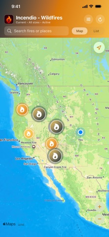
See current reported wildfires across the United States on a clear, native map. Incendio turns the public National Interagency Fire Center WFIGS/IRWIN incident feed into a fast map and list that are easy to scan. Open the app to explore reported wildfire locations, compare incident size and containment, and review available details without digging through a complex data portal. EXPLORE THE CURRENT MAP View reported wildfire incidents across the country with markers scaled by acreage. Optional location access adds distance context and helps center the map near you. FILTER WHAT MATTERS Choose a minimum reported size or focus on incidents below a containment threshold. Prescribed burns are excluded from the default public wildfire feed. SCAN AND SEARCH Switch to the incident list to compare acreage, containment, update time, and distance. Search by incident name, location, reported acreage, or cause. OPEN REPORTED DETAILS Tap an incident to review its reported size, containment, discovery and update times, cause, coordinates, available personnel and management information, and a link to NIFC Open Data. BUILT FOR CLARITY - Current US wildfire map based on the public NIFC WFIGS/IRWIN feed - Map markers scaled by reported acreage - Incident list with containment and update context - Filters for minimum acreage and containment - Search across current results - Optional on-device location and distance calculations - Native on iPhone and iPad - No account, ads, or in-app tracking IMPORTANT SAFETY INFORMATION Incendio is an informational viewer. It is not an emergency notification, evacuation, prediction, or official incident-command service. Incident data can be incomplete or delayed. For immediate threats and evacuation information, follow local emergency officials. Incident data provided by NIFC WFIGS / IRWIN.
Details