

RCAP: Your Trips, Mapped
SilverAI Joint Stock Company · Travel
Independent analytics for this App Store listing. AppTracker is not affiliated with SilverAI Joint Stock Company.
Chart standing · US
What changed · US
Listing changes AppTracker has observed for this app in this storefront — new versions, price moves, rating shifts, and store copy.
Improvements & bug fixes.
In-app purchases · US
What this app sells inside itself, grouped by kind and priced for this storefront.
Screenshots




About
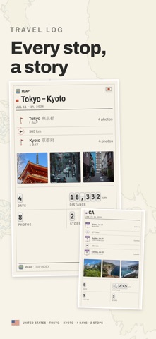
RCAP finds the trips already sitting in your photo library, and draws each one as a map worth printing. It reads the dates and coordinates your camera saved, works out where one trip ended and the next began, and assembles the route — the days, the stops, the distance. Nothing to log, nothing to tag, nothing to fill in. FIVE WAYS TO PRINT ONE TRIP Sheet — the dense one: every stop named, the photographs counted, a tally for each day. Trek — the route as the subject: numbered stops, with the distance and the time on every leg. Plain — the ground lettered like an atlas, edge to edge. Pin — your photographs standing on the map at the coordinates they were taken. Text — the itinerary as plain text, for pasting into a message. The paper turns with the journey: a trip down a coastline comes out landscape, a weekend in one city comes out portrait. THE PASSPORT Every country you have stood in, stamped on one page and read over a chart of the world. SHARING Send a print straight to Instagram Stories, or copy a trip's index and paste it onto a background of your own. ON YOUR DEVICE Your photos never leave your device. There is no account to create, and no server holds your library — the trips, the maps and the prints are all made on the phone. Street-level maps for a country are downloaded the first time you open a trip there, and can be deleted again in Settings. RCAP PRO Takes the RCAP mark off the footer of a print. Monthly, yearly, or bought once. Map data © OpenStreetMap contributors, ODbL. Terms of Use (EULA): https://silverai.com/rcap/term/
What's new · 1.2.1
Improvements & bug fixes.
Details