

Huck: Idaho Trail Maps
Farpine LLC · Navigation
Independent analytics for this App Store listing. AppTracker is not affiliated with Farpine LLC.
Chart standing · US
What changed · US
Listing changes AppTracker has observed for this app in this storefront — new versions, price moves, rating shifts, and store copy.
Avalanche danger, free: turn on the layer to see every avalanche zone that touches Idaho, colored by its danger rating, with the center's travel advice and a link to the full forecast. The centers start rating for the season in late November; until then most zones say there's no current forecast. With Huck+, snow depth: SNOTEL stations on the map with the latest reading and the week before it, and a high trail's card names the nearest station. Hunting, with Huck+: hunt cards now list landowner permission and Landowner Appreciation Program hunts, so an X area no longer says no hunt is listed. Draw odds and harvest always belong to the hunt they're shown on, even after Fish and Game renumbers it, and adult turkey hunts no longer say Youth. Pan the map and the hunt chip names the draws at the middle of the map and which hunt is open, or opens next. A No motors filter shows only the trails for hiking, horses and bikes. A legend now explains every color on the map for the layers you have on. More trail cards say which vehicles may ride them and when, and routes Idaho Parks & Recreation gives a special designation say so, in its own words. Trail time estimates now follow the climb in the direction you're going. A trail that crosses a region line is one trail, so a heart on one shows on both. Trail names draw in every region you download, the miles ahead stay steady as you zoom, the map no longer stutters while you follow a trail, and a download cut short by closing the app comes back paused, ready to resume, instead of leaving a region half-installed. Our privacy policy is updated: with the Avalanche danger layer on, Huck fetches the danger map from avalanche.org, and snow depth readings come from our own server. gohuck.app/privacy
Ratings breakdown · US
The star breakdown behind this app's rating in this storefront.
Screenshots




About
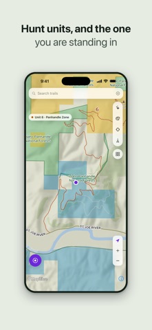
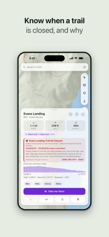
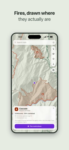
Idaho's trails, offline. All of them. Huck stores every trail and forest road in Idaho on your phone. No signal, no data plan, no "downloading map…" spinner at the trailhead. Airplane mode, dead zones, deep canyons — the map just works. EVERY TRAIL, FROM THE AGENCIES THAT MAINTAIN THEM Merged across those agencies and refreshed regularly: trail numbers, surface, difficulty, elevation profiles, and which uses are allowed — hike, horse, bike, moto, ATV. BUILT FOR WHERE THERE IS NO SERVICE • Full offline vector maps with hillshaded terrain • Turn-by-turn driving directions to trailheads, routed over forest roads • Record your track — distance, time, pace, and live speed • Drop and share waypoints; save the trails you return to • Search every trail by name or number, plus trailheads and OHV areas • No account, no login, no ads KNOW BEFORE YOU GO • Closures and area restrictions on the map, with the order and its dates • Trail seasons — open and close dates, and whether each is open now, so you don't drive to a locked gate • Trail notes from Idaho Parks & Recreation, like a stretch over private ground • Avalanche danger — every zone that touches Idaho, with travel advice HUCK+ An optional yearly subscription. The maps, GPS, tracking, and turn-by-turn above stay free forever, and closures, season dates and avalanche danger are free too. • Hunt units — every Idaho GMU and elk zone, and the unit you're in • Controlled hunt areas — every draw boundary by species, and which one you're in • Wildlife management areas — outlined and named on the map • Public land — forest, wilderness, BLM and state ground, whose is whose • Campgrounds & lookouts — campgrounds, lookouts and rental cabins, with Recreation.gov links to check dates • Weather downloads — grab the forecast before you lose bars • Snow depth — SNOTEL stations, the latest reading and the week before it • Satellite imagery — offline aerial packs for every region YOUR LOCATION STAYS YOURS Huck keeps your position and tracks on your phone and its backup until you share them, or ask for a Huck+ forecast where you stand: the Weather Service gets that spot. No analytics, no tracking. Idaho Panhandle is included with the app. Five more regions download free. Terms of Use: https://gohuck.app/terms Privacy Policy: https://gohuck.app/privacy
What's new · 1.5.4
Avalanche danger, free: turn on the layer to see every avalanche zone that touches Idaho, colored by its danger rating, with the center's travel advice and a link to the full forecast. The centers start rating for the season in late November; until then most zones say there's no current forecast. With Huck+, snow depth: SNOTEL stations on the map with the latest reading and the week before it, and a high trail's card names the nearest station. Hunting, with Huck+: hunt cards now list landowner permission and Landowner Appreciation Program hunts, so an X area no longer says no hunt is listed. Draw odds and harvest always belong to the hunt they're shown on, even after Fish and Game renumbers it, and adult turkey hunts no longer say Youth. Pan the map and the hunt chip names the draws at the middle of the map and which hunt is open, or opens next. A No motors filter shows only the trails for hiking, horses and bikes. A legend now explains every color on the map for the layers you have on. More trail cards say which vehicles may ride them and when, and routes Idaho Parks & Recreation gives a special designation say so, in its own words. Trail time estimates now follow the climb in the direction you're going. A trail that crosses a region line is one trail, so a heart on one shows on both. Trail names draw in every region you download, the miles ahead stay steady as you zoom, the map no longer stutters while you follow a trail, and a download cut short by closing the app comes back paused, ready to resume, instead of leaving a region half-installed. Our privacy policy is updated: with the Avalanche danger layer on, Huck fetches the danger map from avalanche.org, and snow depth readings come from our own server. gohuck.app/privacy
Details