

Gyral Tides
Gyral LLC · Weather
Independent analytics for this App Store listing. AppTracker is not affiliated with Gyral LLC.
Chart standing · US
What changed · US
Listing changes AppTracker has observed for this app in this storefront — new versions, price moves, rating shifts, and store copy.
Ocean currents go global. Modeled surface currents from the E.U. Copernicus Marine Service now animate across the map worldwide, not just in US waters. Wind and wave animations have been retuned for a smoother, more realistic look. The map legend is now a simple tile grid, and Voice Control can now select search results and open every section.
Price & rating history · US
Reconstructed from the listing changes AppTracker has observed in this storefront. A field is charted once it has changed more than once, and each line starts at the value it moved from.
Average rating · ★ 5.00 now · 2 changes on record
Ratings breakdown · US
The star breakdown behind this app's rating in this storefront.
Screenshots



About
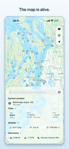
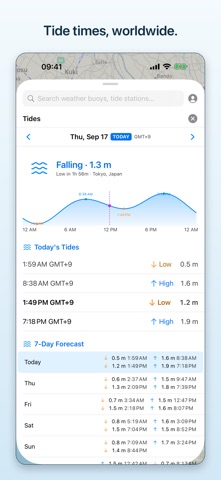
Gyral Tides is a fun, map-based app for seeing what's going on near or on the water — tide predictions for coastlines worldwide, plus global ocean currents animated right on the map. The map is the centerpiece — and it's alive. Wind streams across the surface, waves roll through at the real local period and direction, and tide stations glow with the state of the tide. WHAT YOU CAN DO • Tides — the water level right now, not just the next high and low. Computed on your device from published harmonic constituents, so you can jump to any day, past or future. Charts, high/low times, and a 7-day forecast for thousands of stations, from Puget Sound to Tokyo Bay, the English Channel, and New Zealand. • Currents — worldwide ocean currents animated on the map, modeled by the E.U. Copernicus Marine Service. Speed and direction predictions at NOAA current stations (US), computed the same way as tides. • Weather — current conditions, hourly forecast, marine-zone forecasts, and marine-warning alerts with optional notifications. • Wind & waves — animated overlays you can actually enjoy watching. • Buoys — live offshore observations from NOAA buoys, right on the map. • Astronomy — sun and moon rise/set, phase, and altitude charts. • Search — jump to a station, a buoy, a beach, a surf break, or a harbor. • Widgets — the next tide on your home screen, per-widget station choice. WHERE THE DATA COMES FROM • Tides: thousands of harmonic stations worldwide, each with its own local time and its own chart datum. • Currents: worldwide surface currents from the E.U. Copernicus Marine Service; NOAA current stations (US). • Buoys and marine-zone forecasts and warnings: United States (NOAA). • Weather, wind, and waves: worldwide. BUILT TO BE PLEASANT • No signal needed for tides — predictions are computed on your device, not fetched. (Map tiles, weather, buoys, and the currents overlay still need a connection.) • Light, Dark, and System appearance. • Your units, everywhere: distance, wind, temperature, tide height, pressure, and time format. • Accessible: VoiceOver, Dynamic Type, and reduced motion. • Private by design: no accounts, no ads, no tracking, and anonymous usage stats you can switch off. Gyral Tides is for information and enjoyment only — it is NOT a navigation tool and no substitute for professional marine navigation. It's for the joy of watching the water.
What's new · 1.2
Ocean currents go global. Modeled surface currents from the E.U. Copernicus Marine Service now animate across the map worldwide, not just in US waters. Wind and wave animations have been retuned for a smoother, more realistic look. The map legend is now a simple tile grid, and Voice Control can now select search results and open every section.
Details