

釣果ノート 潮見表
AKIHIRO MATSUYAMA · Sports
Independent analytics for this App Store listing. AppTracker is not affiliated with AKIHIRO MATSUYAMA.
Chart standing · US
What changed · US
Listing changes AppTracker has observed for this app in this storefront — new versions, price moves, rating shifts, and store copy.
- The upgrade screen now lists what you can already use as it is (map, catch log, tide and weather, fish encyclopedia, backup). - Improved wording in several languages, including singular and plural forms such as "1 trip". - No placeholder amount is shown anymore when product details cannot be loaded.
In-app purchases · US
What this app sells inside itself, grouped by kind and priced for this storefront.
Screenshots


About
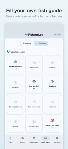
Does your secret spot leak through your fishing app? Fishing Log is a private fishing diary. It is not a social network: nothing is posted or shared. Your catches and photos stay on your device. ●Snap it, the rest is automatic Take a photo and the date, place (GPS), tide phase and weather are logged. Species and size can be added later. ●Read the tide, pick your day Today's tide chart (high and low times, dawn and dusk windows, sunrise and sunset) is there as soon as you open the app. A monthly tide calendar shows when the next spring tide is. ●A gentle heads-up the day before a spring tide (optional) Turn it on in Settings and you are notified only on the evening before a spring tide. It is off by default, and the check runs on your device. ●Your own spot map Every spot you fished is pinned on a map; tap a pin to see what you caught there before. All pins are free to view, and exact locations stay on your device. ●Review shows your patterns Charts by species, tide phase and time of day, plus a personal-best hall of fame. ●A fish book that grows Each species you catch fills in your fish book. ●Log the zero-catch days too A skunked day is still data, and it makes your spot, tide and weather trends more accurate. ●One-time purchase. No subscription The app is free, with no ads and no subscription. A few extras are unlocked by a one-time Premium purchase: the full favourite-spots list (free: top 3), full by-species chart and personal-best hall of fame (free: top 6 and top 8), CSV export, and several photos per record. The map, records, photos, weather, tide, notifications, fish book and backup work without buying anything. ●Your privacy ・No sign-up or login ・Your catches and photos are never stored on or sent to our servers ・To show weather and tide, a rounded location (about 5 km) is sent to weather services (weather: MET Norway, tide: Open-Meteo Marine). Nothing that identifies you is sent ・Maps load tile images from the GSI Japan server (no catches or photos are sent); outside Japan, from the OpenFreeMap server ・Location data (Exif) in photos is removed automatically ・Backup export and import are supported Tide phase, tide level and sunrise/sunset are estimates. Tide level is a weather-model estimate, not a tide-gauge measurement, and real tides vary by place. Map data: GSI Japan tiles / OpenFreeMap © OpenMapTiles, © OpenStreetMap contributors / Weather forecast data by MET Norway (CC BY 4.0) / Marine data by Open-Meteo.com
What's new · 1.1.6
- The upgrade screen now lists what you can already use as it is (map, catch log, tide and weather, fish encyclopedia, backup). - Improved wording in several languages, including singular and plural forms such as "1 trip". - No placeholder amount is shown anymore when product details cannot be loaded.
Details