

TowRiver
Torben Rytt · Navigation
Independent analytics for this App Store listing. AppTracker is not affiliated with Torben Rytt.
Chart standing · US
Ratings breakdown · US
The star breakdown behind this app's rating in this storefront.
Screenshots


About
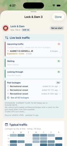
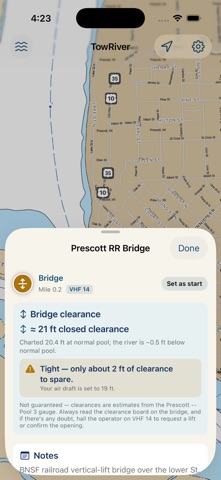
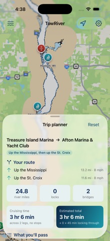
TowRiver is a trip-planning and live-conditions companion for boaters on the Upper Mississippi River, the St. Croix, and the Illinois Waterway — from the Twin Cities down to St. Louis and up the Illinois to Lockport. Everything below is free to use during early access. MAP & NAUTICAL CHARTS • Interactive river map with the USACE Inland ENC nautical charts built in — bundled for the whole river, so they work with no signal. • Marinas, locks & dams, and every movable (opening) bridge on the three rivers. TRIP PLANNER • Pick a start and destination and get distance, the locks and bridges you'll pass, and an estimated running time based on your own cruising speeds. • Routes across the Prescott and Grafton confluences automatically. LIVE LOCK TRAFFIC & TOWS • See who's waiting, in the chamber, and inbound at each lock, in real time. • Underway tows plotted on the map with ETAs, plus each boat's usual route. • A typical-traffic heat map so you know the busy days and hours before you go. BRIDGE CLEARANCE FOR YOUR BOAT • Enter your air draft and movable bridges are color-coded green / yellow / red by whether you'll clear them at the current river level — read live off the nearby gauge. Always confirm against the clearance board or the bridge operator. RIVER CONDITIONS & WEATHER • Live river stage and flood status from NOAA gauges. • National Weather Service forecasts along your route. WHERE AM I • A GPS view that snaps your position to the channel and shows the next lock, bridge, and marina up- and down-river. NOT FOR NAVIGATION TowRiver is a planning aid, not a navigational instrument. Lock, traffic, chart, weather, and position data may be delayed, approximate, or incomplete. Always navigate with official charts, U.S. Coast Guard Notices to Mariners, working onboard equipment, and sound judgment. Map data © OpenStreetMap contributors. Lock & traffic data: U.S. Army Corps of Engineers. River & weather: NOAA / National Weather Service. Charts: USACE Inland ENC.
Details