

BlueHelm Boating
Blue Helm LLC · Navigation
Independent analytics for this App Store listing. AppTracker is not affiliated with Blue Helm LLC.
Chart standing · US
What changed · US
Listing changes AppTracker has observed for this app in this storefront — new versions, price moves, rating shifts, and store copy.
Add your boat in two minutes: builder, model and year, and BlueHelm looks up the published figures for you to check. Water is shaded by charted depth, with rocks, wrecks, kelp and bridges from NOAA charts. Courses follow the deeper water and note shallow stretches, locks and bridges. Your boat asks seven short questions, then answers about your own boat. When it doesn't know, it looks online and shows its sources. Sign in and your boats, guides and documents come back on any phone.
Ratings breakdown · US
The star breakdown behind this app's rating in this storefront.
In-app purchases · US
What this app sells inside itself, grouped by kind and priced for this storefront.
Screenshots


About
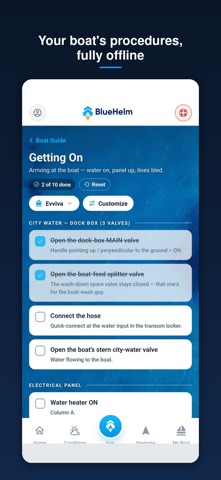
Navigation, Anchor-drift alarm. Live float plans. Marine weather. And your boat's own guide — with you at the helm, even offline. BlueHelm is built around YOUR boat: its systems, procedures, and checklists become a guide you can actually use underway, with the safety tools running alongside. YOUR BOAT (AI) Ask questions and get answers drawn from your boat's guide plus current conditions. "Where's the A/C seacock?" "What do I shut off on the inverter?" Boating questions only — and it never replaces your own judgment or official sources. ANCHOR WATCH Drop anchor, set your rode, and BlueHelm watches your swing. If your boat drifts past your ring, the alarm sounds — even with the screen off. Adaptive monitoring is designed to be easy on your battery overnight. TRIPS & FLOAT PLANS Plan a trip with a suggested water route, or just tap Track Now and go. Share a live float plan so the people who worry can watch your track. Every trip is saved with distance and time. SMART WATER ROUTING Plan a trip and BlueHelm suggests a route over real water — out the harbor channel, around the headland, never a straight line across land. In US waters, routing is informed by NOAA chart data. A planning suggestion to refine, not navigation — always verify against official charts. FIND NEAREST The closest marinas, fuel docks, launch ramps, harbors, anchorages, and bays — sorted by distance from your position, with over 17,000 US coastal places built in. Works with zero signal, exactly when you need it. Tap any place to plan a route there, or just ask Your Boat. TRAVEL WINDOW A same-day read on wind and swell, scored hour by hour, so you can pick the calm window instead of guessing. Transparent about its sources and thresholds — a planning aid, not a go/no-go verdict. MARINE CONDITIONS Wind, tide, waves, and water temperature with hourly and 7-day forecasts, tide charts, and NOAA coastal alerts in US waters. VESSEL GUIDE Your boat's procedures — getting on, heading out, heading back, closing up — as living checklists that work fully offline. Multi-boat ready: every vessel keeps its own guide, log, and documents. MOB & EMERGENCY One-tap man-overboard marking and an emergency console with your position ready to read over the radio. MEMBERSHIP — STRAIGHT PRICES 14-day free trial, no card required. Crew: $9.99/month or $99/year. Captain (higher AI allowance): $17.99/month or $199/year. Add a boat: $49/year. No ads. We never sell your data, and your guide content is never used to train AI. BlueHelm is an aid to seamanship — not a substitute for it. Always maintain a proper lookout, monitor official forecasts and notices, and carry required safety equipment. AI answers can be wrong; verify anything safety-critical against your boat's documentation. Questions? services@getbluehelm.com Terms of Use (EULA): https://www.apple.com/legal/internet-services/itunes/dev/stdeula/ Privacy Policy: https://getbluehelm.com/legal
What's new · 2.2.0
Add your boat in two minutes: builder, model and year, and BlueHelm looks up the published figures for you to check. Water is shaded by charted depth, with rocks, wrecks, kelp and bridges from NOAA charts. Courses follow the deeper water and note shallow stretches, locks and bridges. Your boat asks seven short questions, then answers about your own boat. When it doesn't know, it looks online and shows its sources. Sign in and your boats, guides and documents come back on any phone.
Details