

GeoProof: GPS Camera & Survey
Grima Hdez · Photo & Video
Independent analytics for this App Store listing. AppTracker is not affiliated with Grima Hdez.
Chart standing · US
What changed · US
Listing changes AppTracker has observed for this app in this storefront — new versions, price moves, rating shifts, and store copy.
Each new photo is now also saved to your Photos library with the stamp on it (turn it off in Settings). New coordinate converter in Settings: paste MGRS, UTM, DMS or decimal and get all four. Projects can be renamed. The upgrade screen now lists only what Pro really includes.
In-app purchases · US
What this app sells inside itself, grouped by kind and priced for this storefront.
Screenshots


About
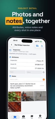
GeoProof turns your iPhone into a GPS field camera that stamps every photo with where and when it was taken — built for inspectors, surveyors, construction crews, and anyone whose photos have to hold up later. Every shot is stamped with a clean, professional overlay and saved with its full location data. WHAT GETS STAMPED • GPS coordinates — decimal, DMS, MGRS and UTM • Altitude, accuracy, heading, speed and bearing • Reverse-geocoded street address • Date and time • Project name, custom notes and your company logo • A map inset pinning the exact spot PROOF YOU CAN STAND BEHIND Every photo is cryptographically signed on-device and tamper-evident, so you can show a file hasn't been altered since capture. Your documentation is built to survive scrutiny — disputes, claims, audits and reports. ORGANIZED FOR REAL WORK • Group captures into projects per site, job or inspection • Search by address, project, caption or coordinates • See every photo plotted on a map • Export PDF reports, photo bundles and GPX points • Every capture also saved to Photos with the stamp on it (optional) • Coordinate converter: paste MGRS, UTM, DMS or decimal • Apple Watch app, Home Screen widget and Spotlight EVERYTHING INCLUDED MGRS/UTM formats, street address and custom overlays aren't locked behind a separate "industry" add-on — they're part of the app. PERFECT FOR Construction progress • Site & safety inspections • Land and utility surveying • Insurance and damage claims • Real estate • Environmental and field research • Legal and evidentiary documentation Note: GeoProof's signature makes tampering evident; it is not a legal chain-of-custody guarantee. Location accuracy depends on your device and network conditions. COMMON QUESTIONS What exactly does it stamp on a photo? Coordinates in the format you pick (decimal, DMS, MGRS or UTM), altitude, accuracy, address, date and time, and compass bearing. You choose which of those appear and where. Is it proof in a legal sense? It is evidence, not proof. It records what the phone's GPS, compass and clock reported at capture time, and shows the accuracy figure so you can judge it. No app can certify that a phone was not fooled. Does it need internet? Not for capturing. The address needs a connection; coordinates, altitude and bearing do not. Offline maps (Pro) can be downloaded ahead of the job. What can I hand over at the end? A PDF report, a spreadsheet, a KML or GPX file, or the whole project as a bundle. Is there a watermark on free photos? Free exports carry a small GeoProof mark, and PDF reports a Made with GeoProof footer. Pro removes both and adds your own logo. Does it work on iPad? Yes. Terms of Use: https://masaapps360.com/geoproof/terms/ Privacy Policy: https://masaapps360.com/geoproof/privacy/
What's new · 1.2.1
Each new photo is now also saved to your Photos library with the stamp on it (turn it off in Settings). New coordinate converter in Settings: paste MGRS, UTM, DMS or decimal and get all four. Projects can be renamed. The upgrade screen now lists only what Pro really includes.
Details