

Flybound
Lenny Tropiano · Travel
Independent analytics for this App Store listing. AppTracker is not affiliated with Lenny Tropiano.
Chart standing · US
What changed · US
Listing changes AppTracker has observed for this app in this storefront — new versions, price moves, rating shifts, and store copy.
TOMORROW, ALTITUDE — AND A WAY TO TELL FLYBOUND IT'S WRONG Plan tonight for tomorrow, fly at your real altitude each way, and take a field out of the decision when you know better than the data. NEW: PLAN TONIGHT FOR TOMORROW • Set a leave time more than 3 hours out — or tap Tomorrow 8 AM or 1 PM — and every airport is scored on its forecast for when you'd arrive, not today's weather. An orange chip says you're looking at a forecast. • Past the end of a forecast, the guess is shown as CAUTION, never GO, and the app tells you when the next forecasts arrive. YOUR CRUISE ALTITUDE, EACH WAY • New: Usual cruise altitude, per aircraft. Every trip is planned from the altitude you actually fly, rounded to the legal VFR altitude for the direction — so "8,500" westbound becomes 7,500 eastbound. • The return leg is planned as its own flight: its own altitude, with the wind sampled up there instead of borrowed from the way out. The brief shows course, altitude, groundspeed and ETE for each leg. • New: cruise rows and winds aloft now interpolate. At 7,500 the app used to quietly use the 6,000 ft forecast. THE CLIMB IS NOW REAL • New, per aircraft: best rate of climb at Vy and climb fuel flow. Times and fuel now include the climb, which falls off with altitude, so the last 2,000 ft cost the most. • The fuel pad is now Taxi & descent pad; if you padded it for the climb, it can come down. Please note: your trip times and fuel figures will move with this release, and the two legs of a round trip will now differ. They are closer to what you'll actually see. THE RIGHT ALTITUDE FOR THIS TRIP (PRO) • New: in the destination brief, the wind triangle solved at every legal cruising altitude your aircraft can reach — out and back separately, with time and fuel for each. "8,500 ft · about 14 min faster round-trip". • It uses the winds aloft at each level and your own cruise rows, and every altitude pays for its own climb, in minutes and gallons. • Short hops stay low: on a 60 nm leg there is nothing left to cruise at after the climb and descent. • Long legs get sent up, with the reason: three hours out, a tailwind two levels higher can beat the fuel to reach it. • In between it leaves you alone, and won't talk you down to 3,500 to save a minute. • New: a Best altitude switch beside the winds override, off by default. This is a winds answer, not an MEA. Flybound has no terrain data. DISREGARD AN AIRPORT — WHEN YOU KNOW BETTER THAN THE DATA Some fields you will never use: a ramp fee, a runway you won't take, a standing NOTAM, or an AWOS reporting weather nobody around it is flying in. • New: a switch at the bottom of any airport's page leaves that field out of every decision — as a destination, as en-route weather on OTHER routes, as the weather source its neighbours borrow, and as a fuel stop. • That second one is the point. One stuck sensor near your course can turn every route past it amber. Disregard it straight from the "En-route MVFR near KXYZ" line in the brief. • Your home base can't be disregarded. Settings → Disregarded airports undoes any of it, and the list rides iCloud and the CSV export. NEW: SKIP THE AIRPORTS THAT BILL YOU (PRO) • Vector Airport Solutions — "PlanePass" — collects landing and ramp fees at about 135 US fields. Switch it on and Flybound stops offering all of them: as destinations, as en-route weather, and as fuel stops. • Any one goes back with a tap, and stays back. Each shows what the airport itself publishes, with a link to its fee page. Off by default. ALSO: the distance rings now start at 1 hour instead of 2; the route line carries airborne time and round-trip distance; and the home-screen widget and scout alerts no longer fall back to Free limits on a Pro account.
Price & rating history · US
Reconstructed from the listing changes AppTracker has observed in this storefront. A field is charted once it has changed more than once, and each line starts at the value it moved from.
Average rating · ★ 5.00 now · 3 changes on record
Screenshots




About
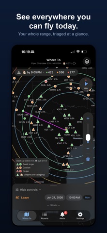
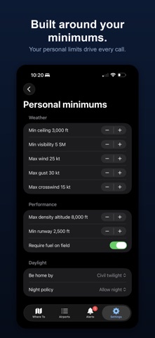
Where can I fly today? Pick a leave time. Flybound draws wind-shaped range rings around your home airport and scores every reachable field GO, CAUTION or NO-GO — from live weather, your aircraft's numbers, daylight, fuel and your own personal minimums. Then it does the part a raw briefing never does: it tells you what would change the answer. IT TELLS YOU WHY — AND WHAT WOULD FIX IT Every CAUTION and NO-GO carries the number: "GO if the ceiling lifts 400 ft." "GO if you leave by 2:15 PM." "GO if it cools 6 °C — try early morning." Ceiling and visibility carry trend arrows with the rate behind them, so a 1,200 ft ceiling that is lifting reads differently from one that is dropping. Put the two together and you get the time to look again: "on this trend, around 2:40 PM." And when nothing will clear it, it says so, and names what is still in the way. YOUR MINIMUMS, NOT SOMEBODY ELSE'S Ceiling, visibility, surface wind, gusts, crosswind, density altitude, runway length, fuel on the field, and your own night policy. Set them once; every field on the map is judged against them. THE WHOLE DAY, NOT JUST THE DEPARTURE - Weather along the route at the time you will actually cross it, not only at the ends. - The forecast at your arrival, and again for the ride home. - Last light, and the be-home-by deadline that follows from it, with night-currency cues. - A fuel-stop planner that sizes the stop and lands it near the true midpoint. - Round-trip or one-way scoring. - An expected-ride estimate — Smooth, A few bumps, Bumpy or Rough — for the passenger who always asks. ALTITUDE Trips are planned at the altitude you actually fly, rounded to the legal VFR altitude for the direction, with the climb modelled properly rather than buried in a flat fuel pad. Pro adds a cruise-altitude card: the wind triangle solved at every legal level your aircraft can reach, out and back separately, each level paying for its own climb. ONCE YOU'RE ON THE GROUND Runways with wind components, frequencies, airspace class, fuel — and things worth walking to, because the point of a day trip is the day, not the flight. KEEP TRACK A Wheels Down log of everywhere you have been, with CSV export. Morning and afternoon scout alerts for the fields you care about. A home-screen widget. FREE AND PRO Free is a real app, not a demo: full GO/CAUTION/NO-GO scoring, personal minimums, route weather, daylight, fuel and the airport briefs — with one aircraft, rings out to 2.5 hours, 50 airports on the map and 10 logged fields. Flybound Pro is $14.99 per month, an auto-renewing monthly subscription; it includes a 14-day free trial. Pro unlocks rings out to 6.5 hours, every airport in range, multiple aircraft and home fields, the cruise-altitude optimizer, winds-aloft override, one-way mode, scout alerts, faster weather refresh, and an unlimited Wheels Down log with CSV import. Lifetime is $59.99 once, with Family Sharing. Everything Pro has, paid for one time. Subscriptions renew automatically unless cancelled at least 24 hours before the end of the current period. Manage or cancel in your App Store account settings. The free trial is available once per account. Terms of Use (EULA): https://flybound.app/terms.html Privacy Policy: https://flybound.app/privacy.html BEFORE YOU FLY Flybound is a planning aid for discovering day trips. It is not a navigation or in-flight app, it carries no terrain data, and it is not a substitute for an official preflight briefing. Verify weather, airspace, runways, frequencies, fuel and NOTAMs against current official sources before every flight.
What's new · 1.0.9
TOMORROW, ALTITUDE — AND A WAY TO TELL FLYBOUND IT'S WRONG Plan tonight for tomorrow, fly at your real altitude each way, and take a field out of the decision when you know better than the data. NEW: PLAN TONIGHT FOR TOMORROW • Set a leave time more than 3 hours out — or tap Tomorrow 8 AM or 1 PM — and every airport is scored on its forecast for when you'd arrive, not today's weather. An orange chip says you're looking at a forecast. • Past the end of a forecast, the guess is shown as CAUTION, never GO, and the app tells you when the next forecasts arrive. YOUR CRUISE ALTITUDE, EACH WAY • New: Usual cruise altitude, per aircraft. Every trip is planned from the altitude you actually fly, rounded to the legal VFR altitude for the direction — so "8,500" westbound becomes 7,500 eastbound. • The return leg is planned as its own flight: its own altitude, with the wind sampled up there instead of borrowed from the way out. The brief shows course, altitude, groundspeed and ETE for each leg. • New: cruise rows and winds aloft now interpolate. At 7,500 the app used to quietly use the 6,000 ft forecast. THE CLIMB IS NOW REAL • New, per aircraft: best rate of climb at Vy and climb fuel flow. Times and fuel now include the climb, which falls off with altitude, so the last 2,000 ft cost the most. • The fuel pad is now Taxi & descent pad; if you padded it for the climb, it can come down. Please note: your trip times and fuel figures will move with this release, and the two legs of a round trip will now differ. They are closer to what you'll actually see. THE RIGHT ALTITUDE FOR THIS TRIP (PRO) • New: in the destination brief, the wind triangle solved at every legal cruising altitude your aircraft can reach — out and back separately, with time and fuel for each. "8,500 ft · about 14 min faster round-trip". • It uses the winds aloft at each level and your own cruise rows, and every altitude pays for its own climb, in minutes and gallons. • Short hops stay low: on a 60 nm leg there is nothing left to cruise at after the climb and descent. • Long legs get sent up, with the reason: three hours out, a tailwind two levels higher can beat the fuel to reach it. • In between it leaves you alone, and won't talk you down to 3,500 to save a minute. • New: a Best altitude switch beside the winds override, off by default. This is a winds answer, not an MEA. Flybound has no terrain data. DISREGARD AN AIRPORT — WHEN YOU KNOW BETTER THAN THE DATA Some fields you will never use: a ramp fee, a runway you won't take, a standing NOTAM, or an AWOS reporting weather nobody around it is flying in. • New: a switch at the bottom of any airport's page leaves that field out of every decision — as a destination, as en-route weather on OTHER routes, as the weather source its neighbours borrow, and as a fuel stop. • That second one is the point. One stuck sensor near your course can turn every route past it amber. Disregard it straight from the "En-route MVFR near KXYZ" line in the brief. • Your home base can't be disregarded. Settings → Disregarded airports undoes any of it, and the list rides iCloud and the CSV export. NEW: SKIP THE AIRPORTS THAT BILL YOU (PRO) • Vector Airport Solutions — "PlanePass" — collects landing and ramp fees at about 135 US fields. Switch it on and Flybound stops offering all of them: as destinations, as en-route weather, and as fuel stops. • Any one goes back with a tap, and stays back. Each shows what the airport itself publishes, with a link to its fee page. Off by default. ALSO: the distance rings now start at 1 hour instead of 2; the route line carries airborne time and round-trip distance; and the home-screen widget and scout alerts no longer fall back to Free limits on a Pro account.
Details