
Chart standing · US
What changed · US
Listing changes AppTracker has observed for this app in this storefront — new versions, price moves, rating shifts, and store copy.
Habitat Evidence is now available in Colorado and Wyoming under Map → Layers → Pro Layers. This update also includes performance and stability improvements.
Ratings breakdown · US
The star breakdown behind this app's rating in this storefront.
Screenshots




About
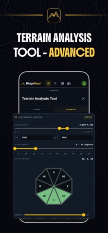
RidgeRead is a hunting map and GPS terrain app for Western hunters who want to scout, plan, and navigate with real confidence miles from cell service. Read the country before you hunt it. Detailed LiDAR, topo, satellite, and hybrid maps, downloadable offline areas, public-land and hunt-unit overlays, and elk-focused terrain analysis help you find access, cover, and likely animal movement. Built for the field: - Offline map areas that work with zero signal - Interactive LiDAR, topo, satellite, hybrid, and historical satellite layers - Public land and hunt unit boundaries - Saved waypoints, pins, and live track recording - Distance and terrain measurement tools - Slope, aspect, and elevation analysis for reading drainages and benches - Trail, motorized road, and road-density layers - Historic fire and timber-cut layers - Elk migration corridor context where available - Privacy Mode keeps your scouting data local on your device - Guide articles and elk hunting knowledge resources RidgeRead puts a practical map, a sharper scouting workflow, and terrain-first decision support in one place. Always verify land ownership, regulations, access rules, closures, and season information with official agency sources before hunting. Terms of Use (EULA): https://www.ridgeread.com/terms Privacy Policy: https://www.ridgeread.com/privacy
What's new · 2.1.1
Habitat Evidence is now available in Colorado and Wyoming under Map → Layers → Pro Layers. This update also includes performance and stability improvements.
Details