

Drone Map: Airspace & Weather
YIGIT CAN TASOGLU · Navigation
Independent analytics for this App Store listing. AppTracker is not affiliated with YIGIT CAN TASOGLU.
Chart standing · US
What changed · US
Listing changes AppTracker has observed for this app in this storefront — new versions, price moves, rating shifts, and store copy.
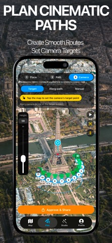
Two new countries, 66 new drones and a sharper route planner. NEW COUNTRIES • Denmark: official Trafikstyrelsen drone zones, refreshed nightly, including temporary no-fly zones for state visits and events • Norway: airport and aerodrome zones added to the map MORE DRONES • 66 new models, including DJI Neo 2, Avata 360, Lito X1 and Lito 1, Matrice 4E, Mavic 3 Enterprise, HoverAir X1 series, Antigravity A1, Autel EVO II, Potensic ATOM 3, Holy Stone, Ruko, Bwine, FIMI and BetaFPV • Separate profiles for Mini drones with the Plus battery, which changes the flight class • Corrected EU class labels for several DJI and Autel models. Your saved drone updates automatically PLAN • Camera beams now show for every waypoint, also when the camera points far away or at the horizon SUBSCRIPTIONS • Clearer plans: every annual price now shows its monthly equivalent Always check the official authority and current NOTAMs before you fly. Drone Map is a planning aid, not a flight authorisation.
Price & rating history · US
Reconstructed from the listing changes AppTracker has observed in this storefront. A field is charted once it has changed more than once, and each line starts at the value it moved from.
Average rating · ★ 0.00 now · 2 changes on record
In-app purchases · US
What this app sells inside itself, grouped by kind and priced for this storefront.
Screenshots


Keywords this app targets
Search terms AppTracker associates with this app — estimates, not search volume. ❝ = in the app's title; a highlighted number is its current position for that term.
Similar apps
Competitors and close alternatives, as estimated by AppTracker.
 Drone Weather - Weather4Fly
Arda Balkan
1 shared topic · 2 shared title words
Drone Weather - Weather4Fly
Arda Balkan
1 shared topic · 2 shared title words
 Drone UAV Fly Forecast: AirMap
MONIQ TAP COMPANY LIMITED
1 shared topic · 1 shared title word
Drone UAV Fly Forecast: AirMap
MONIQ TAP COMPANY LIMITED
1 shared topic · 1 shared title word
 Drone Map & UAV Forecast
Christopher Hefferman
1 shared topic · 2 shared title words
Drone Map & UAV Forecast
Christopher Hefferman
1 shared topic · 2 shared title words
 Drone Weather Forecast
Renan Rafael Bertoldo
1 shared topic · 2 shared title words
Drone Weather Forecast
Renan Rafael Bertoldo
1 shared topic · 2 shared title words
 Dronecast: UAV & Drone Weather
Pinverse LTD
1 shared topic · 2 shared title words
Dronecast: UAV & Drone Weather
Pinverse LTD
1 shared topic · 2 shared title words
 DroneKoll - Airspace and map
Kristoffer Nordgren
2 shared title words
DroneKoll - Airspace and map
Kristoffer Nordgren
2 shared title words
 Drone UAV Forecast DJI Air Map
Metin Atalay
2 shared title words
Drone UAV Forecast DJI Air Map
Metin Atalay
2 shared title words
 Drone Spot – Forecast and Map
Erwann Bestard
2 shared title words
Drone Spot – Forecast and Map
Erwann Bestard
2 shared title words
About
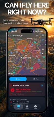
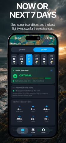
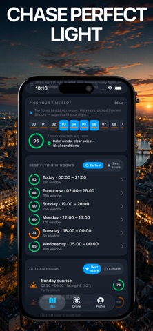
Drone Map Forecast is the cleanest answer to the one question that matters before takeoff: "Can I fly here, right now or in the next 7 days?" One map. Real airspace. Real wind aloft. Tuned to your drone. WHAT MAKES IT DIFFERENT • Airspace and flight weather on a single screen — not two apps, not a PDF • Wind at the altitudes you actually fly (10, 80, 120, 180 m), not just the calm reading on the ground • A 5-level fly verdict (Hazardous → Optimal) that combines wind, gusts, rain, visibility, temperature and any zone you are standing in • Drone-aware: pick your aircraft and the limits adapt — Mini 4 Pro is judged differently than Mavic 3 Pro • Anonymous by design: no sign-in, no accounts, no profile FLY-ZONE COVERAGE 22 countries bundled, with the official live overlays where regulators publish them: • Germany — live DFS dipul WMS (every restricted zone, every embassy, every hospital exclusion) • United States — 7,500+ zones from FAA, plus National Parks (NPS) and USFWS Wildlife Refuges as no-fly • Switzerland — official ED-318 geozones • 19 other countries — curated advisory zones around major airports and sensitive sites Coverage updates automatically when source data changes. No app update needed. WEATHER YOU CAN TRUST • Open-Meteo global forecast — no API key, no quota • Wind speed at 10/80/120/180 m above ground — see the column of air your drone actually fights through • 10-meter gusts overlaid on steady wind • Rain, visibility, cloud cover, temperature, sunrise, sunset, golden hours • NOAA Kp index for GPS reliability PLAN YOUR FLIGHT • 7-day hourly outlook with a verdict color per hour • Best windows — automatically surfaced 1–3 hour flying periods • Golden hour suggestions, sortable by score or by earliest • Tap any hour in the next 24 to get a custom score for that exact slot ON THE MAP • Apple MapKit — Standard, Muted, Satellite, Satellite 3D, Hybrid, Hybrid 3D • Sun bearings drawn from your pin so you can compose against the light • POI toggle for parks, beaches, marinas, campgrounds, stadiums, amusement parks • 1-tap recenter to roughly 500 m around you PRIVACY • No account, no sign-up, no email • Location stays on device unless you opt into update notifications • No advertising SDKs, no analytics SDKs, no third-party trackers • Optional push notifications use an anonymous Apple-issued token DISCLAIMER Drone Map Forecast is a planning aid, not a flight authority. Always confirm local rules and active NOTAMs/TFRs with your national aviation authority before flying. Advisory zones are best-effort — verdicts in those countries are guidance, not regulation. Made by drone pilots, for drone pilots. Drone Map Pro The following features require Drone Map Pro, available as a monthly or annual subscription (3-day free trial) or a one-time Lifetime purchase: • Full airspace restriction map (ENAIRE / DFS / IGN / BAZL / LFV overlays) • All weather charts (rain, visibility, cloud, temperature, Kp space weather) • Wind at flight altitude (10 / 80 / 120 / 180 m wind & gust profile) • 7-day flight planner (best windows, golden-hour timing, and hourly verdicts) Terms of Use (EULA): https://visionlabtech.com/products/drone-map/terms Privacy Policy: https://visionlabtech.com/products/drone-map/privacy
What's new · 1.0.4
Two new countries, 66 new drones and a sharper route planner. NEW COUNTRIES • Denmark: official Trafikstyrelsen drone zones, refreshed nightly, including temporary no-fly zones for state visits and events • Norway: airport and aerodrome zones added to the map MORE DRONES • 66 new models, including DJI Neo 2, Avata 360, Lito X1 and Lito 1, Matrice 4E, Mavic 3 Enterprise, HoverAir X1 series, Antigravity A1, Autel EVO II, Potensic ATOM 3, Holy Stone, Ruko, Bwine, FIMI and BetaFPV • Separate profiles for Mini drones with the Plus battery, which changes the flight class • Corrected EU class labels for several DJI and Autel models. Your saved drone updates automatically PLAN • Camera beams now show for every waypoint, also when the camera points far away or at the horizon SUBSCRIPTIONS • Clearer plans: every annual price now shows its monthly equivalent Always check the official authority and current NOTAMs before you fly. Drone Map is a planning aid, not a flight authorisation.
Details