

FieldNav: MGRS & UTM GPS
PAWEŁ KANDYBOWICZ · Navigation
Independent analytics for this App Store listing. AppTracker is not affiliated with PAWEŁ KANDYBOWICZ.
Chart standing · US
What changed · US
Listing changes AppTracker has observed for this app in this storefront — new versions, price moves, rating shifts, and store copy.
A new look across the app: bigger readouts, quieter framing, and tiles that fill the screen. Navigating no longer depends on a working compass. When the phone has no magnetometer, or it is confused, the rose follows your course over the ground and says so on screen. Bearing, distance and time to target keep working while you walk. Recorded tracks have their own tab now. You can rename one, delete it, and the point count comes from the saved track instead of whatever was still on screen. Fixes for anyone working south of the equator: UTM and MGRS readouts read back correctly, and grid lines are drawn on the ellipsoid of the datum you picked, including the Norway and Svalbard exceptions. Altitude on iOS was corrected twice against the geoid. Now once. A point you mark on the map shows no altitude at all instead of a made-up zero. If a track point cannot be saved, recording stops and tells you, instead of quietly losing the trace. Night mode is complete: the offline maps screen, the map scale bar and the menus stay red, so nothing flashes white in the dark. Waypoint altitude is editable, and you can export a single point or a whole group as GPX.
In-app purchases · US
No in-app purchases.
Screenshots





Keywords this app targets
Search terms AppTracker associates with this app — estimates, not search volume. ❝ = in the app's title; a highlighted number is its current position for that term.
Similar apps
Competitors and close alternatives, as estimated by AppTracker.
 MGRS GPS: Grid & Land Nav
Dajiale
1 shared topic · 2 shared title words
MGRS GPS: Grid & Land Nav
Dajiale
1 shared topic · 2 shared title words
 MGRS & UTM GPS Maps PRO
mustafa pistofoglu
1 shared topic · 3 shared title words
MGRS & UTM GPS Maps PRO
mustafa pistofoglu
1 shared topic · 3 shared title words
 GPS Navigation Offline
Alexander Deplov
3 shared topics · 1 shared title word
GPS Navigation Offline
Alexander Deplov
3 shared topics · 1 shared title word
 Tactical MAP PRO : Navigation
mustafa pistofoglu
2 shared topics
Tactical MAP PRO : Navigation
mustafa pistofoglu
2 shared topics
 MilGPS+
mustafa pistofoglu
1 shared topic
MilGPS+
mustafa pistofoglu
1 shared topic
 TerraGrid: MGRS Tactical GPS
Enes Furkan Bayram
TerraGrid: MGRS Tactical GPS
Enes Furkan Bayram
 MGRS GPS Mapper
Ferkan Sari
1 shared topic · 2 shared title words
MGRS GPS Mapper
Ferkan Sari
1 shared topic · 2 shared title words
 Grid-Nav
Matt Kaili
1 shared topic
Grid-Nav
Matt Kaili
1 shared topic
About
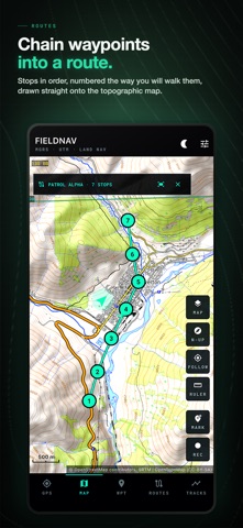
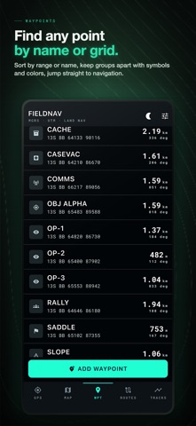
Know your exact grid position, save it, and find your way back — even with no signal, no account, and no subscription. FieldNav is an offline MGRS and UTM GPS for land navigation beyond cell coverage. Read military grid (MGRS) and UTM coordinates, follow a compass with true magnetic declination, drop and find waypoints, build routes, and record tracks. Core navigation and your imported offline maps work with no signal. Built for people who navigate off the pavement: • Search & rescue, ground teams and first responders working on MGRS • Soldiers, veterans, ROTC and land-navigation students • Wildland firefighters, forestry and field crews • Hunters, backcountry hikers and overlanders past cell coverage • Airsoft, milsim, orienteering and geocaching • HAM/SOTA radio operators and off-grid preppers WHAT YOU GET • Real MGRS / UTM grid drawn on the map, with grid lines and labels • Compass with magnetic declination from the full WMM2025 model — true vs magnetic bearing, not a guess • GPS averaging that shows RMS sample spread before you save a mark • Waypoints in named groups, with symbols and colors • Leg-by-leg routes with bearings, distance and arrival alerts • Track recording with distance and DTG • Offline maps — load your own MBTiles tile sets and navigate with no signal • Import / export GPX, KML and CSV • Ruler for instant distance and azimuth (degrees and mils) • Datum support: WGS84, NAD27, OSGB36, AGD66, ED50 • Red night-vision mode that dims the map and the readouts OFFLINE & PRIVATE BY DESIGN Core navigation works fully offline. No accounts, no ads, no tracking, no analytics. Your marks, routes and tracks stay on the phone — FieldNav has no server to send them to. Online map tiles come from the map provider you pick, the same as in any map app; download your area and even that stops. PAY ONCE A single purchase unlocks every included feature. No subscriptions, no in-app purchases. Know your grid. Trust your bearing. Find your way back.
What's new · 1.0.3
A new look across the app: bigger readouts, quieter framing, and tiles that fill the screen. Navigating no longer depends on a working compass. When the phone has no magnetometer, or it is confused, the rose follows your course over the ground and says so on screen. Bearing, distance and time to target keep working while you walk. Recorded tracks have their own tab now. You can rename one, delete it, and the point count comes from the saved track instead of whatever was still on screen. Fixes for anyone working south of the equator: UTM and MGRS readouts read back correctly, and grid lines are drawn on the ellipsoid of the datum you picked, including the Norway and Svalbard exceptions. Altitude on iOS was corrected twice against the geoid. Now once. A point you mark on the map shows no altitude at all instead of a made-up zero. If a track point cannot be saved, recording stops and tells you, instead of quietly losing the trace. Night mode is complete: the offline maps screen, the map scale bar and the menus stay red, so nothing flashes white in the dark. Waypoint altitude is editable, and you can export a single point or a whole group as GPX.
Details