

Velocipede GPX Builder
Colbey Chittenden · Navigation
Independent analytics for this App Store listing. AppTracker is not affiliated with Colbey Chittenden.
Chart standing · US
What changed · US
Listing changes AppTracker has observed for this app in this storefront — new versions, price moves, rating shifts, and store copy.
Velocipede 1.2 — POIs on your maps, POI import, and tidier editing. POIS ON YOUR MAPS • Layers → POI Collections: switch a collection on and its points show on the map in Route mode and in Ride mode, so the stops you collected are there while you ride • A pin's callout now has Add to Route — on a POI, or on a named place from a layer such as Sample Waypoints — and it becomes the next stop in your route POI MODE • Import POIs from GPX… in the ⋯ menu, under + on the map, and in Manage Collections. The file's waypoints land in your active collection • A share button at the top of the POI list, and Export in Manage Collections, so exporting is not only a swipe • Edit in the POI list: select several POIs, then delete them or move them to another collection. Clear all is under ⋯ • Edit in Manage Collections: select collections and delete them together • Deleting a collection asks first — it takes its POIs with it MAP • Map style — standard, hybrid, satellite — at the top of the Layers sheet, in every mode including Ride FIXES • "My POIs" no longer multiplies with every device and reinstall. The copies iCloud has already synced are merged into one, and every POI is kept • Deleting your last collection no longer brings an empty "My POIs" straight back; one is created the moment you add a POI • Ride mode's descriptions say what it is: it follows your route and records nothing
Screenshots





About
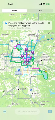
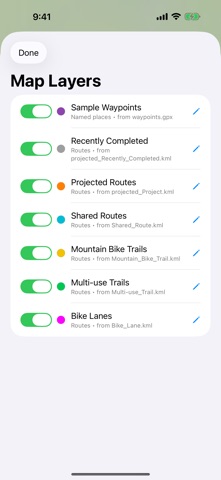
Velocipede is a focused tool for cyclists and group ride organizers who need a clean way to plan routes and mark up points of interest. Plan the ride, mark the places worth stopping, then follow the route on the day — rebuilt from the ground up in SwiftUI for iPhone and iPad. THREE MODES, ONE MAP Route Mode plans an ordered ride between waypoints you drop on the map. Long-press to add, search by address, or enter raw lat/lon. Generate the route via Apple Maps for real road and path routing, or use straight-line connectors when Apple doesn't know about a trail — for the whole route or a single leg. An imported GPX track can join the route as a fixed segment (or freeze a routed leg you like); generation fills only the gaps. Each leg can be bike, walk, run, or drive. Reverse direction with one tap. Drag to reorder, drag to edit, undo a mistake. Distance and estimated time appear at the top. POI Mode is for capturing collections of points of interest — coffee stops, trailheads, scenic overlooks, anything worth remembering. Keep as many named collections as you like. Drop POIs by long-pressing the map, searching by address, or tapping Current Location while you're moving. Export the whole collection as a wpt-only GPX file ready for Garmin, Komoot, RideWithGPS, or any GPX-aware app. Ride Mode is for the ride itself. It shows one route — a saved one, a GPX track or KML line someone sent you, or the route you just planned — and keeps the map on you, north up or heading up. Nothing in it edits anything. Pan around and the map comes back to you on its own. Optional Route Guidance, off until you turn it on, shows the distance left and warns when you stray; it is worked out on your device. It is deliberately not a navigation app: no turn-by-turn, no recording, no re-routing. SHARE TO WEB Share a generated route as a link. It goes to velocipede.app, where anyone with the link sees the map and the stats and can download the GPX, for 30 days. Five free shares a month, no account, and you can take a link down whenever you like. LAYERS All three modes share map layers — KML or GPX overlays you can switch, recolor, and resize independently. Oklahoma City's bike network ships as a starter set, and Add a City downloads a metro area's bike network from OpenStreetMap — trails, lanes, shared paths, mountain bike trails, and signed routes, each its own layer, with one switch per city. Nine cities so far; ask for yours from the app. OPTIONAL BIKE-AWARE ROUTING Apple Maps has no cycling mode, so a session-only toggle can route cycling legs through Velocipede's own OpenStreetMap-based service, which knows the US bike-lane and trail network. Off by default; if it can't answer, Apple Maps routes the leg. Coordinates are used to answer the request and never stored or logged. CLOUD SYNC Routes, collections, and layers sync between your iPhone and iPad via your own private iCloud database. Toggle it off in Settings if you'd rather keep things local. YOUR DATA There's no account to create and nothing to sign in to. Routes, collections, and layers live on your device and, with sync on, in your own private iCloud — no Velocipede server holds them. Location is used only on your device — to recenter the map, to drop a point where you stand, and to keep the map on you in Ride Mode, never to record your ride; decline it and the app still works. OPTIONAL SUPPORT Velocipede is free, with no paywalls, ads, or feature gates. The tip jar is a one-time thank-you, no subscription, and changes nothing about the app. DIRECT FEEDBACK Send Feedback posts your message straight to the developer's inbox, and the form shows exactly what device info is attached before you send. FILE FORMATS GPX 1.1 export and import, KML import, elevation profiles for tracks that carry elevation data. Works with Garmin Connect, Komoot, RideWithGPS, Strava, and any GPX-aware tool. Open .gpx and .kml files from Mail, Files, or AirDrop — or import one from a link.
What's new · 1.2
Velocipede 1.2 — POIs on your maps, POI import, and tidier editing. POIS ON YOUR MAPS • Layers → POI Collections: switch a collection on and its points show on the map in Route mode and in Ride mode, so the stops you collected are there while you ride • A pin's callout now has Add to Route — on a POI, or on a named place from a layer such as Sample Waypoints — and it becomes the next stop in your route POI MODE • Import POIs from GPX… in the ⋯ menu, under + on the map, and in Manage Collections. The file's waypoints land in your active collection • A share button at the top of the POI list, and Export in Manage Collections, so exporting is not only a swipe • Edit in the POI list: select several POIs, then delete them or move them to another collection. Clear all is under ⋯ • Edit in Manage Collections: select collections and delete them together • Deleting a collection asks first — it takes its POIs with it MAP • Map style — standard, hybrid, satellite — at the top of the Layers sheet, in every mode including Ride FIXES • "My POIs" no longer multiplies with every device and reinstall. The copies iCloud has already synced are merged into one, and every POI is kept • Deleting your last collection no longer brings an empty "My POIs" straight back; one is created the moment you add a POI • Ride mode's descriptions say what it is: it follows your route and records nothing
Details