

Ten Digit – MGRS GPS
Scaleworks LLC · Navigation
Independent analytics for this App Store listing. AppTracker is not affiliated with Scaleworks LLC.
Chart standing · US
What changed · US
Listing changes AppTracker has observed for this app in this storefront — new versions, price moves, rating shifts, and store copy.
Hey team, thank you for the feedback and feature requests. Please keep it coming! What's new: • New name and icon: MGRS GPS is now 10digit • Better Night Vision Mode: the red-light display now covers every screen, sheet and alert • TAK mode (experimental): live Cursor-on-Target with ATAK, iTAK, WinTAK and TAK Server, clearly marked while it's field-tested • Interoperability with MilGPS: import and export .milgpsbackup files to move all your overlays and waypoints between apps • One Import button for every file type, plus full backups of all your data (password-encrypted backups for Pro) • Sort waypoints in an overlay by updated, distance or name, and search them • Custom weapon systems with your own SDZ values in Range Tools • Apply an overlay's color and icon to all of its existing waypoints • Cleaner waypoint editor: one Back button that asks to save, and a better Move to Overlay picker • Team Overlays: more reliable sharing on spotty signal, and faster sync that uses less data • Shared point links now ask before saving a waypoint • Softer launch screen, clearer shared-location text, and lots of fixes
Ratings breakdown · US
The star breakdown behind this app's rating in this storefront.
In-app purchases · US
What this app sells inside itself, grouped by kind and priced for this storefront.
Screenshots




About
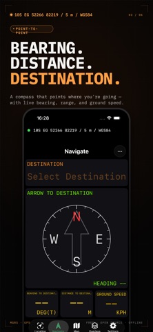
10digit is a free MGRS GPS app built around the Military Grid Reference System — the coordinate format used by the U.S. military, NATO, and search and rescue teams worldwide. It works completely offline with no subscription, no ads, and no account required. FEATURES • Real-time MGRS coordinates — your live position displayed in Military Grid Reference System format, updated continuously via GPS • Offline maps — download and cache map tiles so you can navigate without any cellular or Wi-Fi connection • Waypoint management — save, name, and organize waypoints; navigate between them with bearing and distance readouts • GPX & CSV export — share and back up your waypoints with standard file formats compatible with other GPS tools • KML & KMZ import — bring in map overlays from Google Earth, ATAK, and other planning tools • Ruler tool — measure distances directly on the map between any two points • Background location tracking — continues tracking your position even when the app is backgrounded • Multiple coordinate formats — switch between MGRS, UTM, Latitude/Longitude, and USNG instantly • Move between apps — import and export MilGPS backups (.milgpsbackup), plus GPX, KML, GeoJSON and CSV • Team Overlays — share an overlay with your team, end-to-end encrypted • TAK integration (experimental) — live Cursor-on-Target with ATAK, iTAK, WinTAK and TAK Server • Secure — your waypoints and overlays are encrypted, and can be shared or backed up with password protection WHO IT'S FOR Hunters, hikers, military personnel, veterans, ROTC cadets, first responders, search and rescue volunteers, land surveyors, and anyone who needs reliable offline GPS with military-grade coordinate formats.
What's new · 1.4.2
Hey team, thank you for the feedback and feature requests. Please keep it coming! What's new: • New name and icon: MGRS GPS is now 10digit • Better Night Vision Mode: the red-light display now covers every screen, sheet and alert • TAK mode (experimental): live Cursor-on-Target with ATAK, iTAK, WinTAK and TAK Server, clearly marked while it's field-tested • Interoperability with MilGPS: import and export .milgpsbackup files to move all your overlays and waypoints between apps • One Import button for every file type, plus full backups of all your data (password-encrypted backups for Pro) • Sort waypoints in an overlay by updated, distance or name, and search them • Custom weapon systems with your own SDZ values in Range Tools • Apply an overlay's color and icon to all of its existing waypoints • Cleaner waypoint editor: one Back button that asks to save, and a better Move to Overlay picker • Team Overlays: more reliable sharing on spotty signal, and faster sync that uses less data • Shared point links now ask before saving a waypoint • Softer launch screen, clearer shared-location text, and lots of fixes
Details