

NaturalistTripper
MARTY RADD ICENOGGLE · Travel
Independent analytics for this App Store listing. AppTracker is not affiliated with MARTY RADD ICENOGGLE.
Chart standing · US
What changed · US
Listing changes AppTracker has observed for this app in this storefront — new versions, price moves, rating shifts, and store copy.
Polish on top of 2.0's species map layers. • Photo credits over species images are now just the credit — "© Jane Doe" — instead of a sentence of license boilerplate sitting on the photo. The full line and its license still travel with the photo into saved plans, exported PDFs, and the attribution notice in Settings, so nothing is lost; it simply stops covering the picture. • VoiceOver: in Route mode, the Generate Plan button described a "load a sample" step that no longer exists. It now names the controls that are actually in the route prompt — Import, Maps directions, and the Trails overlay. Questions, bug reports, feature ideas: support@nature-tools.com — a real human reads every message.
In-app purchases · US
No in-app purchases.
Screenshots




About
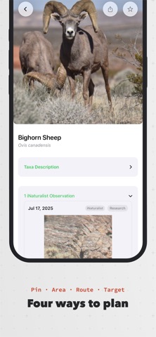
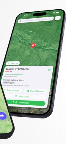
Find wildlife before you go. NaturalistTripper turns millions of community observations into a real trip plan — for birders, botanists, herpers, mushroom hunters, and anyone who travels to see living things. FOUR WAYS TO PLAN • Radius — drop a point and search around it. • Area — draw a polygon over the zone you'll actually cover. • Route — import a GPX, KML, or GeoJSON trail (or pull from Maps directions) and see what's been seen along it. • Species — pick a species and find where it turns up, anywhere. SEE WHERE A SPECIES CONCENTRATES • Heat map — the observations behind a Species search, drawn as a density surface, so a hundred reports over one valley no longer look like a hundred across a state. • Baseline range — the species' expected range underneath, from iNaturalist's curated range maps, or its modelled distribution where none exists. • Observation pins on or off, so the surface stays readable. "Reported here" and "expected here" stay separate claims — the app never merges them. Heat and range are Pro. BACKED BY REAL OBSERVATIONS Three of the largest community science datasets in one map: • iNaturalist — millions of verified species observations • eBird — bird sightings from the Cornell Lab of Ornithology • GBIF — global biodiversity records EVERY OBSERVATION IS RANKED Recency, verifier count, and research-grade status are weighted into a confidence score so you spend your time on sightings that actually mean something. MULTI-STOP TRIPS Chain your saved plans into a single itinerary with a combined species view across every stop — a road trip across hotspots in one shared list. CONDITIONS AT A GLANCE Sunrise, sunset, civil dusk, and moon phase for the day and place you're planning — because dawn light changes everything. WANTLIST Star the species you most want to see. Sightings that match your wantlist get priority in results and trigger optional alerts. ON THE TRAIL • Offline-friendly saved plans with prefetched photos • Optional alerts when fresh sightings appear near a saved plan • Tap any species for an ID sheet with photos, recent sightings, and how to tell it apart EXPORT YOUR PLANS • GPX & KML files with species hotspot waypoints, ready for Garmin, Gaia, or your favorite trail app • Trip Itinerary and Plan Dossier PDFs with embedded map snapshots and species photos • Wantlist field checklist PDF for the pocket • Full library backup — every plan, trip, place, and wantlist entry in one file you keep, ready to import onto a new phone PRIVACY Your location stays on your device. We don't sell data. We don't track you across apps. See our privacy policy for the full story. FREE FOREVER • All four planning modes (Radius, Area, Route, Species) • iNaturalist data in every mode; eBird & GBIF in your monthly Route + Species plans • 2 Route plans / month and 2 Species Finder plans / month • 2 years of observation history per search • Unlimited saved plans • 25-entry Wantlist • Sun & moon Conditions card on every plan • Plan Dossier PDF with map snapshot and species photos • Full backup and restore of your whole library NATURALISTTRIPPER PRO ($3.99/month or $29.99/year, each with a 7-day free trial) • Unlimited Route and Species Finder plans • Species heat map and baseline range layers • eBird + GBIF data in every mode • Up to 20 years of history and full fetch depth • Unlimited Wantlist • Multi-stop Trips with Combined Species view • Sun & moon conditions on the plan summary • Offline downloads with photo prefetch • Sightings Alerts for fresh observations near your saved plans • Trip Itinerary PDFs with embedded map snapshots and species photos QUESTIONS, BUG REPORTS, FEATURE IDEAS support@nature-tools.com — a real human reads every message. Subscriptions auto-renew at the standard rate unless cancelled at least 24 hours before the current period ends. Manage or cancel anytime in your Apple ID Subscriptions. Privacy policy: https://nature-tools.com/privacy Terms of use: https://nature-tools.com/terms
What's new · 2.0.1
Polish on top of 2.0's species map layers. • Photo credits over species images are now just the credit — "© Jane Doe" — instead of a sentence of license boilerplate sitting on the photo. The full line and its license still travel with the photo into saved plans, exported PDFs, and the attribution notice in Settings, so nothing is lost; it simply stops covering the picture. • VoiceOver: in Route mode, the Generate Plan button described a "load a sample" step that no longer exists. It now names the controls that are actually in the route prompt — Import, Maps directions, and the Trails overlay. Questions, bug reports, feature ideas: support@nature-tools.com — a real human reads every message.
Details