

RockHoundR: Rockhounding Map
Ruby Glint Technologies Co., Ltd · Navigation
Independent analytics for this App Store listing. AppTracker is not affiliated with Ruby Glint Technologies Co., Ltd.
Chart standing · US
What changed · US
Listing changes AppTracker has observed for this app in this storefront — new versions, price moves, rating shifts, and store copy.
- New map conditions layers for snow, rain, and fire - Adjust map layer opacity with new sliders - See claim details and who to contact before you dig - Former claims now show on the map so you can spot newly open ground - Improved geology layer with a cleaner look - Improved spot filters and list - New email sign-in - Performance improvements and bug fixes
Price & rating history · US
Reconstructed from the listing changes AppTracker has observed in this storefront. A field is charted once it has changed more than once, and each line starts at the value it moved from.
Average rating · ★ 4.60 now · 31 changes on record
Ratings breakdown · US
The star breakdown behind this app's rating in this storefront.
In-app purchases · US
What this app sells inside itself, grouped by kind and priced for this storefront.
Screenshots




Keywords this app targets
Search terms AppTracker associates with this app — estimates, not search volume. ❝ = in the app's title; a highlighted number is its current position for that term.
Similar apps
Competitors and close alternatives, as estimated by AppTracker.
 RockHound
EasyStreet Apps
1 shared topic
RockHound
EasyStreet Apps
1 shared topic
 Rock Identifier & Snap ID
升 徐
Rock Identifier & Snap ID
升 徐
 Rock Identifier: Stone ID
Next Vision Limited
Rock Identifier: Stone ID
Next Vision Limited
 Metal Detecting Hub: Rodek
Neagoe Andrei
Metal Detecting Hub: Rodek
Neagoe Andrei
 Rock & Stone Identifier App
Henry Heisenberg Apps, LLC
Rock & Stone Identifier App
Henry Heisenberg Apps, LLC
 Rock Identifier : Rockfy
BASAK GEDIK
Rock Identifier : Rockfy
BASAK GEDIK
 RockIn Rock & Mineral identify
Vortemol Limited
RockIn Rock & Mineral identify
Vortemol Limited
 Rock Identifier: AI Scan
Manuel Worlitzer
Rock Identifier: AI Scan
Manuel Worlitzer
About
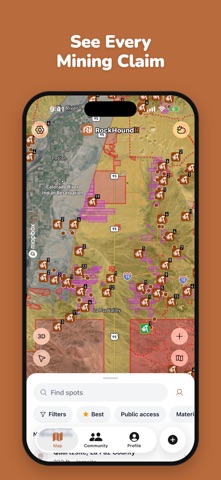
RockHoundR is the map every rockhound, prospector, and fossil hunter has been waiting for. Find collecting sites, know where it's legal to dig, check for mining claims, and keep a log of every find, all in one app. DISCOVER THOUSANDS OF SPOTS Browse a curated map of rockhounding spots and fossil sites across the country. Tap any pin to see what's been found there, how to get there, and whether it's open to the public. Filter by best spots, public access, or the material you're after. KNOW WHERE YOU CAN LEGALLY COLLECT Turn on land layers for BLM, National Forest, National Parks, and more to see which areas allow casual collecting and which don't. Tap anywhere on the map to see who manages the land, with the field office phone number and website. SEE EVERY MINING CLAIM Collecting on someone's active claim can get you in real trouble. With Pro, see active mining claims on the map, tap one for its serial number, type, and status, and see claims that have been closed. DETAILED SITE INFORMATION Every spot includes: • What rocks, minerals, and fossils have been found • Land agency and access rules • GPS coordinates and directions • Weather and trip-planning info • The source of the record SEE THE ROCKS UNDER YOUR FEET Turn on the geology layer to see surface rock colored by age, from Precambrian to today. Tap an era to learn what to look for there. PLAN YOUR TRIP Check the weather at any site before you drive out. With Pro, see wildfires, snow, and rain on the map. Find nearby fuel, restrooms, water, and campgrounds so you know what you're walking into. YOUR COLLECTION Log every find with photos, location, and notes. Finds are private by default, and you choose who sees each one. Add catalog numbers, weights, and sizes to keep your collection organized. DRAW YOUR OWN ROUTES Draw lines on the map to mark trails you've walked, ground you've covered, or routes you want to come back to, and see the distance. OFFLINE-READY Download map areas before you head into the field. Cell service is rare where the good rocks are, and RockHoundR keeps working when your signal doesn't. JOIN THE COMMUNITY Share finds, follow other rockhounds, and get help naming a mystery rock. Find a rockhounding club near you or start your own, with field trips and events in one place. WHO IT'S FOR • Rockhounds and gem hunters • Fossil collectors • Prospectors and gold panners • Mineral and crystal collectors • Geology students and educators • Anyone who likes spending a Saturday outside with a hammer Whether you're chasing agates on the Oregon coast, prospecting in the Mojave, or hunting Herkimers in upstate New York, RockHoundR puts the whole country's collecting map in your pocket. Download RockHoundR free. Browse the map, see spot details, get directions, and log your finds at no cost. ROCKHOUNDR PRO Upgrade to Pro to unlock the tools that matter most in the field: • Land layers: BLM, Forest Service, parks, and more • Mining claims: active and closed claims on the map • Conditions: wildfire, snow, and rain layers • Offline maps: download any area and keep working with no signal • 3D terrain: scout the landscape before you head out • Route tools: custom line colors and elevation profiles • GPX and KML import and export • Collection tools: print QR specimen labels and export to CSV Pro is available as a monthly or yearly subscription, with a 7-day free trial on the yearly plan. Payment is charged to your Apple ID at confirmation of purchase. Subscriptions auto-renew unless cancelled at least 24 hours before the end of the current period. Manage or cancel anytime in your Apple ID settings. Terms of Use (EULA): https://www.apple.com/legal/internet-services/itunes/dev/stdeula Privacy Policy: https://rockhoundr.com/privacy-policy Contact us: support@rockhoundr.com Find out more about RockHoundR at: https://rockhoundr.com
What's new · v2.2.0
- New map conditions layers for snow, rain, and fire - Adjust map layer opacity with new sliders - See claim details and who to contact before you dig - Former claims now show on the map so you can spot newly open ground - Improved geology layer with a cleaner look - Improved spot filters and list - New email sign-in - Performance improvements and bug fixes
Details