
Chart standing · US
What changed · US
Listing changes AppTracker has observed for this app in this storefront — new versions, price moves, rating shifts, and store copy.
ON THE CHART Tap a marker callout to Inspect it — a read-only detail view, so there's no Delete sitting where you meant to tap. Shared markers and validation pins open the same way, and shared detail now shows the icon and colour the sender chose. Heading-up seats your boat low on the screen, putting more of the water ahead in view. The crosshair now steps aside while you're under way — pan the chart to bring it back. Course arrows account for map bearing, so they agree with the predictor no matter which way the chart is turned. You can stop navigation straight from the instruments cluster, and a deleted marker no longer leaves you navigating to nothing. Navigation lines are straight-line only, and the app now says so once, up front. The offline download box is sized from the map you're actually looking at, rather than a fixed span — zoom in for a smaller download, out for a wider one. CATCHES Log the depth along with your catch. It pre-fills from the charted depth under the pin and stays editable, so it's right when the chart isn't. Every catch now shows where it sat against the nearest tide change, and the tide reads in plain language — rising and falling for height, incoming and outgoing for current. Share a catch and the tide and depth travel with it. The app no longer pre-fills a catch position from a GPS fix too weak to trust, and an edited marker coordinate now actually saves. GROUPS A shared position shows speed and course, not just a dot. Your groups appear straight away from cache while they refresh, and a share that hits a slow connection queues instead of failing. REFERENCE Pinch-zoom, pan and reset-to-fit on species photos for a closer look. Marine VHF and GMRS guidance are now a single two-tab reference, offline as always. ALSO Bottom tab labels reflow instead of clipping at large text sizes, and subscribers no longer start the ads engine at all.
Ratings breakdown · US
The star breakdown behind this app's rating in this storefront.
Screenshots





About
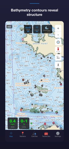
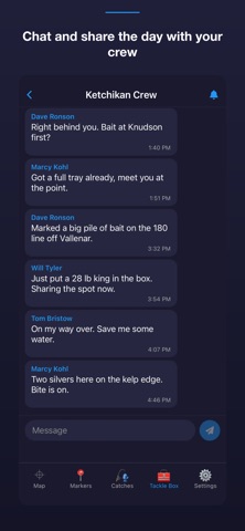
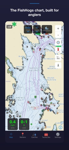
FishHogs is a marine chartplotter for anglers fishing US coastal waters and the Great Lakes. View official NOAA nautical charts, track your GPS position and heading, check the tide, and log every fish you catch — all from one simple app. NOAA charts and GPS are free and work without an account. NOAA NAUTICAL CHARTS Access official NOAA electronic navigational charts (ENC) rendered as high-quality vector tiles. See channel markers, depth contours, hazards, and aids to navigation. Charts load fast and render cleanly at any zoom level. GPS POSITION & HEADING See your real-time position and heading on the chart. FishHogs uses your device GPS — no external hardware required. Works anywhere you have satellite signal, even without cell service. TIDES, CURRENTS & WEATHER Check the tide curve for your local station with high and low times, flood and ebb states, and the day's fishing windows. Currents and marine weather sit alongside the tide, with water levels for the Great Lakes where tides do not apply. CATCH LOG Log a fish with species, weight, length, and the spot you caught it — one tap adds your current location. Search and sort your history by species, size, or date, and keep a whole season in one place. MARKERS Drop markers on fishing spots, structure, hazards, or any point of interest. Add notes, edit names and details, and sync them across your devices when you sign in. GROUPS & SHARING Create a group for your crew and share markers, catches, and live position on the water. Invite by link or QR code. You choose which group sees your position, and you can turn it off at any time. Creating a group requires Premium; joining a group and sharing within it are free. GROUP CHAT Message your group from the boat. Messages queue while you are out of range and send when signal returns, so a dead zone does not cost you the conversation. TACKLE BOX On-the-water references: a fish ID guide for Southeast Alaska and the Gulf Coast with photos and scientific names, marine VHF radio channels, fishing regulations, and a halibut weight calculator. FISHHOGS PREMIUM Premium unlocks the layers that show you structure — the bathymetry contour overlay, FishHogs Depth mode with graduated depth shading, and the FishHogs chart style — and removes banner ads. NOAA charts, GPS, markers, the catch log, tides and conditions, joining a crew group, and the Tackle Box remain free. ACCOUNTS Sign in with Google or Apple to sync markers and catches across your devices, join groups, and manage a subscription. NOAA charts and GPS work without an account. Built by anglers who got tired of paying for chart subscriptions. FishHogs uses free NOAA data, so official nautical charts stay free. SUBSCRIPTION FishHogs Premium is an auto-renewing subscription offered monthly or annually. Payment is charged to your account at confirmation of purchase. It renews automatically at the same price each period unless cancelled at least 24 hours before the end of the current period. You can manage or cancel your subscription in your account settings. Terms of Use (EULA): https://www.apple.com/legal/internet-services/itunes/dev/stdeula/ Privacy Policy: https://fishhogs.app/privacy IMPORTANT NOTICE FishHogs is intended as a fishing and recreational reference tool. Chart data is sourced from NOAA and is provided for general reference only. This app is not a substitute for official NOAA nautical charts, Coast Guard Light Lists, or Notice to Mariners publications, and must not be used as the sole means of navigation.
What's new · 0.8.6
ON THE CHART Tap a marker callout to Inspect it — a read-only detail view, so there's no Delete sitting where you meant to tap. Shared markers and validation pins open the same way, and shared detail now shows the icon and colour the sender chose. Heading-up seats your boat low on the screen, putting more of the water ahead in view. The crosshair now steps aside while you're under way — pan the chart to bring it back. Course arrows account for map bearing, so they agree with the predictor no matter which way the chart is turned. You can stop navigation straight from the instruments cluster, and a deleted marker no longer leaves you navigating to nothing. Navigation lines are straight-line only, and the app now says so once, up front. The offline download box is sized from the map you're actually looking at, rather than a fixed span — zoom in for a smaller download, out for a wider one. CATCHES Log the depth along with your catch. It pre-fills from the charted depth under the pin and stays editable, so it's right when the chart isn't. Every catch now shows where it sat against the nearest tide change, and the tide reads in plain language — rising and falling for height, incoming and outgoing for current. Share a catch and the tide and depth travel with it. The app no longer pre-fills a catch position from a GPS fix too weak to trust, and an edited marker coordinate now actually saves. GROUPS A shared position shows speed and course, not just a dot. Your groups appear straight away from cache while they refresh, and a share that hits a slow connection queues instead of failing. REFERENCE Pinch-zoom, pan and reset-to-fit on species photos for a closer look. Marine VHF and GMRS guidance are now a single two-tab reference, offline as always. ALSO Bottom tab labels reflow instead of clipping at large text sizes, and subscribers no longer start the ads engine at all.
Details