

Hunting Maps & GPS: WikiHunt
Akos Komuves · Navigation
Independent analytics for this App Store listing. AppTracker is not affiliated with Akos Komuves.
Chart standing · US
What changed · US
Listing changes AppTracker has observed for this app in this storefront — new versions, price moves, rating shifts, and store copy.
• GPS track recording is now free for everyone. Tap the red button on the map. • Public land now shows state trust and wildlife land too, from USGS data. • Layers marks every free layer FREE. Private-land parcels are the only paid one. • Hunting units keep loading even when a state's map server is down. • Import is easier to find, and you can also import on a computer at wikihunt.app.
Screenshots


Keywords this app targets
Search terms AppTracker associates with this app — estimates, not search volume. ❝ = in the app's title; a highlighted number is its current position for that term.
Similar apps
Competitors and close alternatives, as estimated by AppTracker.
 MGRS & UTM GPS Maps PRO
mustafa pistofoglu
MGRS & UTM GPS Maps PRO
mustafa pistofoglu
 Swiss Pro Map
Garzotto GmbH
Swiss Pro Map
Garzotto GmbH
 Coordinates – GPS Converter
Mapnitude Company Limited
Coordinates – GPS Converter
Mapnitude Company Limited
 Tactical GPS - MGRS Land Nav
Ivan Blajic
Tactical GPS - MGRS Land Nav
Ivan Blajic
 Topography
Georgios Graikousis
Topography
Georgios Graikousis
 Tractor GPS Field Guidance PRO
Orin Light Limited
Tractor GPS Field Guidance PRO
Orin Light Limited
 UTM Geo Map Y2Tech
Yogi Yogantara
UTM Geo Map Y2Tech
Yogi Yogantara
 Ways Map : Open Street View
Vasundhara Infotech LLP
Ways Map : Open Street View
Vasundhara Infotech LLP
About
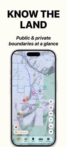
WikiHunt is the GPS hunting map that puts public land overlays, private parcel boundaries, and offline topo on a single map - built by hunters, for hunters. WHAT'S FREE — FOREVER • Public land overlays (BLM, USFS, NPS, FWS, state trust and wildlife land), color-coded by agency • Game Management Units for 21 states • GPS track recording for hunts and scouting trips • Import waypoints from onX, HuntStand, Google Earth, CalTopo or Garmin (GPX, KML, KMZ, GeoJSON); export GPX or KML • Web map at wikihunt.app: plan on a big screen, synced with your phone • Hunting weather: wind direction, barometric pressure, sunrise/sunset, moon phase • Season dates by state and species • 10 waypoints with hunter-specific categories (treestand, trail cam, sign, harvest, etc.) • Hunts — group your waypoints by trip or property and filter the map to one hunt • Trail camera manager • Safety check-in for solo hunts • PLSS grid and BLM Surface Management overlays • Distance and area measurement • Topographic base map ALL STATES — $7.99/month or $39.99/year • Private parcel boundaries for 12 states: Minnesota, Utah, North Carolina, Montana, Wisconsin, California, Vermont, Arkansas, Colorado, Virginia, Washington, Alaska • Unlimited waypoints with photo attachments • Import tracks and areas from other apps • Offline topographic maps — download tiles for any area, hunt with no signal • Full Hunt Forecast: 7-day outlook, peak windows and Good-Day Alerts • Harvest log with weapon, GMU, weight, antler points, photos, notes • Harvest CSV export • Hunt groups — share waypoints with your party, see members on the map, real-time messaging SINGLE STATE — $19.99/year • All Pro features above • Private parcel boundaries for one state of your choice A NOTE FROM THE BUILDER WikiHunt was built because hunting maps shouldn't cost $100 a year. Public land data is free forever. The Pro tier funds new state coverage, server costs, and continued development. Subscriptions auto-renew unless cancelled at least 24 hours before the period ends. Manage or cancel anytime in your Apple ID Settings. Privacy Policy: https://wikihunt.app/privacy Terms of Use (EULA): https://www.apple.com/legal/internet-services/itunes/dev/stdeula/
What's new · 1.5.6
• GPS track recording is now free for everyone. Tap the red button on the map. • Public land now shows state trust and wildlife land too, from USGS data. • Layers marks every free layer FREE. Private-land parcels are the only paid one. • Hunting units keep loading even when a state's map server is down. • Import is easier to find, and you can also import on a computer at wikihunt.app.
Details