

FO Maps: GeoPDF GPS Offline
juan carlo abuin pampaloni · Productivity
Independent analytics for this App Store listing. AppTracker is not affiliated with juan carlo abuin pampaloni.
Chart standing · US
What changed · US
Listing changes AppTracker has observed for this app in this storefront — new versions, price moves, rating shifts, and store copy.
• Photos you take carry the coordinates and date written onto the image, so the information travels with them even when shared through messaging apps. You can turn it off in Settings. • Two compasses, each with one clear job: the map compass shows where north ended up (tap to straighten, press and hold to lock it) and the one in the bottom bar shows the direction you are travelling while moving, or the direction the phone is facing while stopped. • Fixed: the GPS cursor shifted off-centre when you increased its outline thickness, and the map compass turned the wrong way. • Add map layers with a web address: satellite, cadastral, topographic services or your own drone orthophotos. Free on every plan. • Rebuilt offline map: its own screen, real progress from the moment you tap download, and the areas you already have are marked on the map. • Customisable scale bar: colour, outline, thickness, text size and an optional background. You can also hide it. • Instrument panel on the map: compass, bearing, coordinates, altitude and scale bar. • Four GPS modes: center, follow, follow with compass, and compass only. And turning it on no longer changes your zoom level. • A gear button gathers all your project settings, and draw, measure and import KML, KMZ and GPX now sit under a single button. • Markers no longer spin when you rotate the map, so labels stay readable. • When exporting, you can save the file to your phone, not just share it. • Pick the colour and thickness of your GPS cursor so it stands out on any terrain. • Full-size camera button while recording a track, and the tab bar collapses to show more map. • Fixes: the compass no longer freezes, and joining with a code now tells you what went wrong when it fails.
Ratings breakdown · US
The star breakdown behind this app's rating in this storefront.
In-app purchases · US
What this app sells inside itself, grouped by kind and priced for this storefront.
Screenshots
About
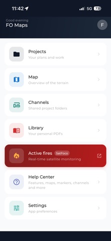
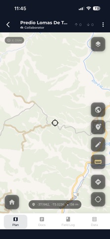
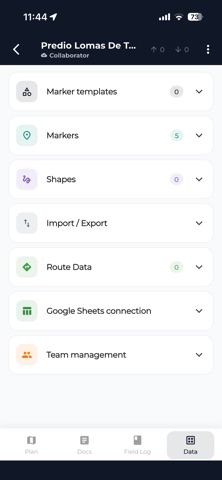
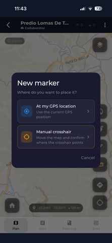
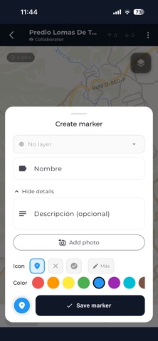
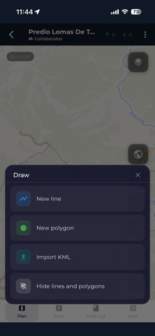
FO Maps turns your phone into a field GIS that works without a single bar of signal. Load the georeferenced maps you already have and work on top of them: drop points, draw polygons, measure distances and areas, record your track, and export everything once you are back online. Nothing leaves your phone unless you want it to. MAPS YOU ALREADY HAVE · GeoPDF from QGIS, ArcGIS, Global Mapper and the USGS US Topo series · MBTiles and georeferenced images · Several maps per project, with adjustable opacity · Generate a GeoPDF from the app to share ON THE MAP · Instrument panel: compass, bearing, coordinates, altitude and scale bar · Four GPS modes, from center-only to follow with compass · Markers with your own templates, multiple photos, and GPS or manual coordinates · Polygon and polyline drawing three ways: crosshair, freehand and GPS track · Layers with visibility, color and icon · Distance and area measurement TRACKS · Record your track with altitude at every point · Take photos with notes as you walk: each one is pinned to that exact moment · Play the track back on the map, pausing at every photo · Export it as a vertical video to share GETTING DATA OUT · KML and KMZ with embedded photos, layers as folders and each point's real icon · GPX with per-point timestamps · PDF reports of the map with its markers · Google Sheets, synced automatically · Backup to your own Google Drive · Save any export straight to your phone TEAMS · Channels: your crew joins with a code, no accounts to create · Publish projects and follow the activity wall · Sync across your own devices MAPS AND WEATHER · Downloadable OpenStreetMap base map for use with no signal, up to 100 km · Hillshade and topographic styles · 9-day forecast and alerts for heat, cold, rain, snow, wind and UV · Discover: a catalog of maps published by organizations, free and without an account 17 languages, including right-to-left support. PLANS Free: maps, drawing, markers and export, with ads. Explorer: hillshade and topographic styles, offline base map, weather, no ads. Pro: everything above plus sync, channels and team collaboration. Built with real crews: forestry roads, wildlife surveys, land surveys, and installations where there is no signal. Support: contacto@faenaoffline.com Web: https://faenaoffline.com/maps/ --- Terms of Use (EULA): https://www.apple.com/legal/internet-services/itunes/dev/stdeula/ Privacy Policy: https://faenaoffline.com/privacy/
What's new · 2.0.22
• Photos you take carry the coordinates and date written onto the image, so the information travels with them even when shared through messaging apps. You can turn it off in Settings. • Two compasses, each with one clear job: the map compass shows where north ended up (tap to straighten, press and hold to lock it) and the one in the bottom bar shows the direction you are travelling while moving, or the direction the phone is facing while stopped. • Fixed: the GPS cursor shifted off-centre when you increased its outline thickness, and the map compass turned the wrong way. • Add map layers with a web address: satellite, cadastral, topographic services or your own drone orthophotos. Free on every plan. • Rebuilt offline map: its own screen, real progress from the moment you tap download, and the areas you already have are marked on the map. • Customisable scale bar: colour, outline, thickness, text size and an optional background. You can also hide it. • Instrument panel on the map: compass, bearing, coordinates, altitude and scale bar. • Four GPS modes: center, follow, follow with compass, and compass only. And turning it on no longer changes your zoom level. • A gear button gathers all your project settings, and draw, measure and import KML, KMZ and GPX now sit under a single button. • Markers no longer spin when you rotate the map, so labels stay readable. • When exporting, you can save the file to your phone, not just share it. • Pick the colour and thickness of your GPS cursor so it stands out on any terrain. • Full-size camera button while recording a track, and the tab bar collapses to show more map. • Fixes: the compass no longer freezes, and joining with a code now tells you what went wrong when it fails.
Details