

FireGuard 112+
CHRISTOS ZAIKIS · Weather
Independent analytics for this App Store listing. AppTracker is not affiliated with CHRISTOS ZAIKIS.
Chart standing · US
What changed · US
Listing changes AppTracker has observed for this app in this storefront — new versions, price moves, rating shifts, and store copy.
- Added a new Earthquakes section with recent seismic events, map view and proximity notifications from international data sources. - Expanded satellite intelligence with Sentinel-2 imagery where available, alongside NASA FIRMS, VIIRS, MODIS and Copernicus EFFIS. - Improved active wildfire and urban fire incident mapping and satellite-assisted location matching where supported. - Expanded awareness for storms, floods, snow, frost, heat, extreme cold and strong winds where data is available. - Improved SOS coordinate sharing when activated by the user. - Improved proximity alerts for important nearby incidents up to 50 km. - Added Critical Alerts support for urgent wildfire and safety notifications. - Added larger text support for improved readability and accessibility. - Refreshed the daytime interface with a new orange visual identity and clearer hazard cards. - Improved reliability, maps, stability and performance.
In-app purchases · US
No in-app purchases.
Screenshots



Keywords this app targets
Search terms AppTracker associates with this app — estimates, not search volume. ❝ = in the app's title; a highlighted number is its current position for that term.
Similar apps
Competitors and close alternatives, as estimated by AppTracker.
 Fireguard Wildfire Tracker
Qvyshift LLC
1 shared title word
Fireguard Wildfire Tracker
Qvyshift LLC
1 shared title word
 Fault Line - Earthquakes
Murat Kuslu
Fault Line - Earthquakes
Murat Kuslu
 Earth Observery
Mahmoud Suliman
Earth Observery
Mahmoud Suliman
 WildFire-Ready
Jeffery Parr
1 shared topic
WildFire-Ready
Jeffery Parr
1 shared topic
 DisasterNet — Quakes & Fires
Ahmet Ein
DisasterNet — Quakes & Fires
Ahmet Ein
 Earthquake Network - Panic
Ayla YILDIZ
Earthquake Network - Panic
Ayla YILDIZ
 EU Fires
Walter Tengler
EU Fires
Walter Tengler
 Emergency situation
Morgan Camilleri
Emergency situation
Morgan Camilleri
About
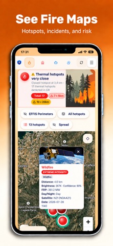
FireGuard is a personal safety app designed to help you stay informed about fires, natural hazards, severe weather and emergencies. It brings together nearby incident information, fire activity, weather conditions, hazard alerts, earthquake updates and practical emergency tools in one easy-to-use app. FIRE AND HAZARD AWARENESS Stay aware of what is happening around you with: - Active fire incidents where available - Wildland information - Interactive fire and hazard maps - Satellite-based indications of possible thermal activity - Alerts for important nearby incidents - Fire-danger information based on local weather conditions - Earthquake, flood and winter-hazard information where available EARTHQUAKE INFORMATION FireGuard includes a dedicated earthquake section with recent seismic events, map information and nearby-event notifications. Earthquake information is provided after an event has been detected. FireGuard is not an earthquake early-warning system and cannot predict earthquakes before they occur. SEVERE WEATHER AND NATURAL HAZARDS Depending on your location and available information, FireGuard may provide awareness for: - Flood risk - Thunderstorms and severe weather - Snow - Frost and icy conditions - Heatwaves - Extreme cold - Strong winds and gusts - Earthquakes WEATHER INFORMATION Understand local conditions with: - Hourly forecasts - 5-day forecast - Temperature and feels-like temperature - Humidity - Wind speed and direction - Atmospheric pressure - Precipitation - Air quality - Location-based local weather - Multiple saved locations when enabled EMERGENCY TOOLS FireGuard includes practical tools designed to support you during an emergency: - Personal Emergency Profile - Medical information, allergies, medications and emergency contacts - Quick access to emergency calling - SOS location sharing with coordinates when activated by you - Optional live location sharing with trusted contacts - Notifications for important nearby incidents up to 50 km - Emergency and preparedness checklists - Safety guidance - Offline safety information where available - Critical Alerts support where available LIVE LOCATION SHARING If you need help, FireGuard can let you share your live location with people you trust. Location sharing is optional and controlled by you. You decide when it starts and can stop sharing at any time. ACCESSIBILITY - Larger text support - Clear and simple hazard cards - Light and dark themes - Improved map readability - User-controlled permissions PRIVACY - No advertising - No sale of personal data - No use of personal data for advertising - User-controlled permissions - Location is used only for features that require it, such as nearby hazards, weather and emergency location sharing IMPORTANT NOTICE FireGuard is designed to improve situational awareness and emergency preparedness. It does not replace emergency services, fire departments, civil protection authorities, official weather services, evacuation orders or emergency instructions. Fire locations, weather information, earthquake information and hazard alerts may contain delays, inaccuracies or temporary interruptions. In an emergency, always follow local authority instructions and contact the appropriate emergency service. Stay informed. Stay prepared.
What's new · 2.7.1
- Added a new Earthquakes section with recent seismic events, map view and proximity notifications from international data sources. - Expanded satellite intelligence with Sentinel-2 imagery where available, alongside NASA FIRMS, VIIRS, MODIS and Copernicus EFFIS. - Improved active wildfire and urban fire incident mapping and satellite-assisted location matching where supported. - Expanded awareness for storms, floods, snow, frost, heat, extreme cold and strong winds where data is available. - Improved SOS coordinate sharing when activated by the user. - Improved proximity alerts for important nearby incidents up to 50 km. - Added Critical Alerts support for urgent wildfire and safety notifications. - Added larger text support for improved readability and accessibility. - Refreshed the daytime interface with a new orange visual identity and clearer hazard cards. - Improved reliability, maps, stability and performance.
Details