

Pathr Navigation
Smart Sail Inc · Navigation
Independent analytics for this App Store listing. AppTracker is not affiliated with Smart Sail Inc.
Chart standing · US
What changed · US
Listing changes AppTracker has observed for this app in this storefront — new versions, price moves, rating shifts, and store copy.
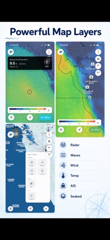
What's New in 1.2.0 This is our biggest update yet, weather that understands your boat, a live radar, friends on the water, and a smarter route planner. For My Boat weather • New "Boat mode" recolors the wind and wave overlays to your own vessel's limits, so you read go / caution at a glance instead of raw numbers. • Honest by design: it shows "limited data" and "no data" states rather than guessing, and stays accurate as you pan and zoom. • Route intelligence: per-leg passage verdicts, wind-against-tide warnings, and reef-timing callouts along your planned route. Live weather radar • Animated radar built on NOAA data, locked smoothly to the chart. • A compact, honest timeline: it shows the latest observation and how old it is (never pretends old data is "now") and tells you when you're outside radar coverage. • Tap anywhere to see the observation time and source. Redesigned weather overlays • Wind, waves, temperature, and radar share one clean, consistent design with tap-anywhere readouts for conditions at any point. • Wind and wave particles now shade by speed and wave height. • New Fishing "active water" overlay highlights current strength over structure, where rips and edges form. Friends & location sharing • Share your location and see friends on the chart, with a Strava-style activity feed and arrival banners. • Find people by name or friend code; control who can find you. • Tap a friend's pin for a richer readout; last-known position stays visible instead of vanishing. • Location sharing now stays on until you turn it off. Route planning • Swap start/end, edit points without losing your plan, and enter an exact latitude/longitude. • Cleaner "review your points" flow and clearer route errors. • Fixed ETA that no longer grows as you approach. Safety & awareness • Marine Alerts: official Coast Guard and NWS hazard and weather notices, with location search. • Anchor Watch: the radius you set is the alarm boundary, with more reliable slow-drag detection and a warning when your radius is tighter than GPS accuracy. • Report floating objects with a drift estimate. Charts & offline • Improved nautical charts with more accurate, hole-free depth data. • Offline chart downloads so you're covered without signal. Also in this release • A lighter, more consistent look that stays light even when your phone is in dark mode. • Smoother, more accurate speed display; color-by-speed breadcrumb trail. • Badge fixes, session-sync fixes, and many refinements throughout.
Ratings breakdown · US
The star breakdown behind this app's rating in this storefront.
In-app purchases · US
What this app sells inside itself, grouped by kind and priced for this storefront.
Screenshots
About
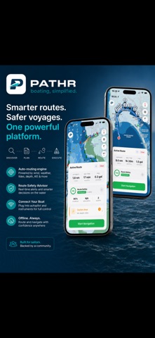
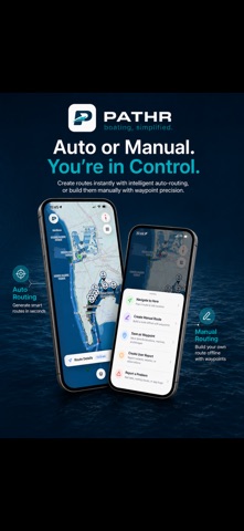
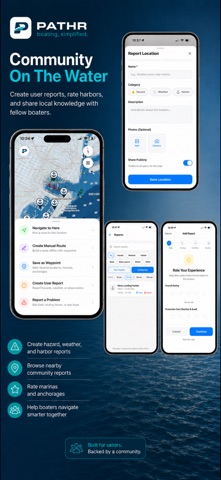
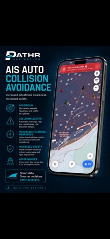
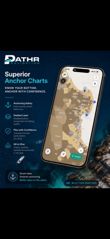
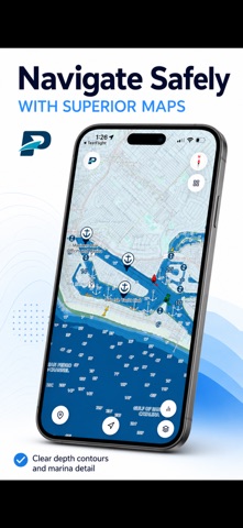
PATHR is modern marine navigation built to make boating simpler, safer, and more fun. Plan your day on the water with smart routing, real marine chart features, weather overlays, AIS awareness, harbor discovery, social sharing, trip tracking, and tools built around how boaters actually move. Whether you are planning a quick cruise, exploring a new harbor, checking conditions, or building a route around your vessel’s limits, PATHR helps bring the whole boating experience into one simple app. Smart Routing Built Around Your Boat PATHR supports both automatic and manual route planning, with routing that considers your vessel profile, including key specs like draft and operating limits. Instead of treating every boat the same, PATHR helps you plan routes that make sense for your vessel, your conditions, and your trip. Our routing experience is designed to help boaters move with more confidence by considering depth, hazards, navigable water, and practical route behavior, not just drawing a straight line from point A to point B. A Better Marine Map Experience PATHR combines high-resolution marine depth data, NOAA chart features, depth contours, aids to navigation, buoys, beacons, lights, wrecks, soundings, bridge clearance data, shoreline detail, and seabed overlays to help with anchoring decisions. The result is a map that feels intuitive, useful, and purpose-built for the water. Important marine information stays front and center without overwhelming the screen. Weather and AIS Awareness View weather overlays while planning and navigating so you can better understand what is happening around you. PATHR also supports AIS overlays, helping you maintain better awareness of nearby vessel traffic. With premium collision-awareness features, PATHR can help identify potential traffic conflicts and give boaters an added layer of situational awareness while underway. Manual Route Planning When You Want Control Prefer to build your own route? PATHR gives you manual routing tools so you can plan exactly where you want to go. Drop points, shape your route, and build a trip that matches your knowledge, comfort level, and local conditions. Explore Harbors and Share What You Find Discover new harbors, anchorages, marinas, and points of interest. Leave reviews, share helpful notes, and learn from other boaters who have been there before. Found a tricky entrance, a great dock-and-dine spot, a quiet anchorage, or something other boaters should know about? Add a map report and help improve the experience for everyone on the water. Social Boating, Built In Boating is better with your people. Add friends, see their location when they choose to share it, send routes, compare adventures, and stay connected on the water. Track your trips automatically and build your own boating logbook over time. Save your routes, review your history, and yes — brag a little. You earned it. The more you sail, cruise, explore, and contribute, the more you can unlock through badges, achievements, and community features. Track Every Trip PATHR records your boating history so you can look back at where you went, how far you traveled, and what you discovered along the way. Whether you are keeping a personal logbook or sharing highlights with friends, your time on the water becomes part of your story. Prop Test Tool Running an adjustable propeller or dialing in your boat’s setup? PATHR includes a prop test feature to help you capture performance data and better understand how your vessel behaves. Built for Real Boaters PATHR is designed for boaters who want powerful tools without the clunky, outdated experience marine software has had for too long. We are building a smarter, cleaner, more connected way to plan, route, explore, and share time on the water. From trip planning to route building, from harbor discovery to social sharing, from weather awareness to vessel-specific routing, PATHR brings the boating experience together in one app. Boating, simplified.
What's new · 1.2.0
What's New in 1.2.0 This is our biggest update yet, weather that understands your boat, a live radar, friends on the water, and a smarter route planner. For My Boat weather • New "Boat mode" recolors the wind and wave overlays to your own vessel's limits, so you read go / caution at a glance instead of raw numbers. • Honest by design: it shows "limited data" and "no data" states rather than guessing, and stays accurate as you pan and zoom. • Route intelligence: per-leg passage verdicts, wind-against-tide warnings, and reef-timing callouts along your planned route. Live weather radar • Animated radar built on NOAA data, locked smoothly to the chart. • A compact, honest timeline: it shows the latest observation and how old it is (never pretends old data is "now") and tells you when you're outside radar coverage. • Tap anywhere to see the observation time and source. Redesigned weather overlays • Wind, waves, temperature, and radar share one clean, consistent design with tap-anywhere readouts for conditions at any point. • Wind and wave particles now shade by speed and wave height. • New Fishing "active water" overlay highlights current strength over structure, where rips and edges form. Friends & location sharing • Share your location and see friends on the chart, with a Strava-style activity feed and arrival banners. • Find people by name or friend code; control who can find you. • Tap a friend's pin for a richer readout; last-known position stays visible instead of vanishing. • Location sharing now stays on until you turn it off. Route planning • Swap start/end, edit points without losing your plan, and enter an exact latitude/longitude. • Cleaner "review your points" flow and clearer route errors. • Fixed ETA that no longer grows as you approach. Safety & awareness • Marine Alerts: official Coast Guard and NWS hazard and weather notices, with location search. • Anchor Watch: the radius you set is the alarm boundary, with more reliable slow-drag detection and a warning when your radius is tighter than GPS accuracy. • Report floating objects with a drift estimate. Charts & offline • Improved nautical charts with more accurate, hole-free depth data. • Offline chart downloads so you're covered without signal. Also in this release • A lighter, more consistent look that stays light even when your phone is in dark mode. • Smoother, more accurate speed display; color-by-speed breadcrumb trail. • Badge fixes, session-sync fixes, and many refinements throughout.
Details