

Oilfield Route: Offline GPS
D'GIS Group Ltd. · Navigation
Independent analytics for this App Store listing. AppTracker is not affiliated with D'GIS Group Ltd.
Chart standing · US
What changed · US
Listing changes AppTracker has observed for this app in this storefront — new versions, price moves, rating shifts, and store copy.
New Lease Roads satellite layer, with images updated weekly, you wont miss any path around well-sites.
Ratings breakdown · US
The star breakdown behind this app's rating in this storefront.
In-app purchases · US
What this app sells inside itself, grouped by kind and priced for this storefront.
Screenshots


About
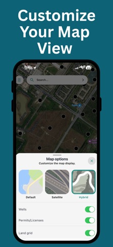
Wellsite routes calculate on your phone if offline, on a server if online. Oilfield Route is a well search and GPS navigation app for oil and gas crews working past the edge of cell coverage. Download your state once. After that, search wells, calculate a route, and follow turn-by-turn directions with the phone in airplane mode. You do not have to preload one exact route before you leave coverage. WHAT OFFLINE ACTUALLY MEANS HERE (with a PRO Subscription) Offline here does not mean a cached well list, and it does not mean one route you had to plan before you left. Oilfield Route calculates the route on the device. - Search wells and saved locations offline - Calculate a brand-new route offline including multi-stop route optimization - Reroute after a missed turn, offline - Full turn-by-turn guidance, offline - Works with the phone in airplane mode FIND WELLS, THEN GET TO IT - Search by API number or well name - Most US well names carry the lease name, so the lease finds the well - Operator, depth, drill date, well status, substance and more well details - Toggle wells and permits layers on the map - Save wells and locations into organized groups - Share a location or a whole group with your crew ROUTING FOR FIELD VEHICLES - Car, light-truck and heavy-truck route profiles - Multi-stop route planning and optimization - Navigate to the wellsite, lease or coordinates, not a street address - Highways, county roads and access roads - Street, satellite and hybrid map views FILTER BY WELL STATUS, INCLUDING ORPHANED WELLS Find orphaned wells and focus your map on the sites relevant to your work. Filter by Orphaned, Active, Abandoned, and other available statuses to reduce map clutter and help plan field visits, inspections, and reclamation work. PLANS Essential - online well search, well data, location sharing, and online route calculation and turn-by-turn navigation. Pro - everything in Essential, plus downloadable offline maps, offline route calculation, offline turn-by-turn, and vehicle-optimized routing. COVERAGE 17 US states: Alaska, California, Colorado, Illinois, Kansas, Louisiana, Mississippi, Montana, New Mexico, North Dakota, Ohio, Oklahoma, Pennsylvania, Texas, Utah, West Virginia and Wyoming. Plays inside that footprint include the Permian Basin, the Bakken, the Eagle Ford, the Anadarko Basin, the Haynesville, the DJ Basin and the Marcellus. Crews who work both sides of the border also get Alberta, British Columbia, Saskatchewan and Manitoba. A subscription is required for mapping, well search and navigation. Always confirm site access, road conditions and safety requirements on the ground - this app assists navigation, it does not replace field judgment. Built by GeoActivity, 15+ years in oil and gas software. Terms of Use: https://oilfieldroute.com/terms.html Privacy Policy: https://oilfieldroute.com/privacy.html
What's new · 1.2.84
New Lease Roads satellite layer, with images updated weekly, you wont miss any path around well-sites.
Details