

GPXExplore: GPX Track Viewer
ObjectGraph LLC · Navigation
Independent analytics for this App Store listing. AppTracker is not affiliated with ObjectGraph LLC.
Chart standing · US
What changed · US
Listing changes AppTracker has observed for this app in this storefront — new versions, price moves, rating shifts, and store copy.
• See the ground under any track in 3D, in shaded relief or satellite, with its climbs marked on the hills (Pro) • Fly the Route: a camera rides the track ahead of you, at the pace and height you choose (Pro) • Make a flyover video of a ride to post, vertical, square or horizontal, with its profile and climbing (Pro) • Record a track, free: tap Record a Track, and the GPX file is saved when you end • Print a cue sheet: every turn with its street and distance, and each climb, on pages to tape to the stem • Elevation gain reads true on noisy GPS and watch recordings, which used to count their jitter and spikes as climbing • Preview GPX files in Messages, Mail and Files, and find every setting in one place • Open a workout from WorkoutGPX in one tap, and keep your workouts and rides in iCloud Drive to open them on your Mac • Find a Place finds mountains, lakes and rivers again
Price & rating history · US
Reconstructed from the listing changes AppTracker has observed in this storefront. A field is charted once it has changed more than once, and each line starts at the value it moved from.
Average rating · ★ 4.33 now · 5 changes on record
Ratings breakdown · US
The star breakdown behind this app's rating in this storefront.
In-app purchases · US
No in-app purchases.
Screenshots




About
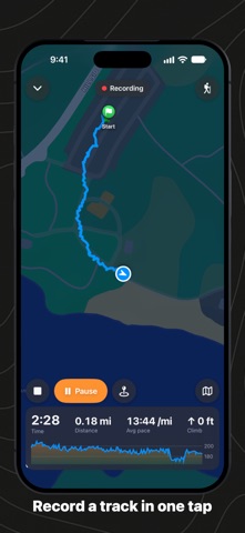
Open any GPX file and see everything in it: the track on the map, and its elevation, heart rate, speed, cadence, power and temperature on the chart below, with the distance, time, pace, climbing and splits. From any watch, bike computer or app. THE WHOLE FILE, ON THE MAP AND THE CHART Open a GPX from Files, iCloud Drive, Mail, Messages or AirDrop, recorded by Garmin, Wahoo, Coros, Suunto, Apple Watch, Strava or Komoot. The chart under the map shows the elevation or any series the file recorded: heart rate, speed, cadence, power, temperature. Slide along it and the map follows. The track is painted by grade: green on the flat, orange and red on the steep pitches, blue on the way down. Every track, route and waypoint in the file, with its peaks and valleys, on standard, satellite or hybrid maps. EVERY NUMBER Distance, moving and elapsed time, pace, average and top speed, elevation gain and loss, heart rate, and splits per mile or kilometer. Elevation gain reads true even on noisy GPS and watch recordings. EVERY CLIMB, BEFORE YOU GO Every climb on the route is found and rated from Category 4 to HC, with its length, gain and grade, and shaded on the chart. RECORD A TRACK One tap records your walk, run, hike or ride, with the time, distance, pace and climb as you go, Pause and Resume, and waypoints, on the Lock Screen too. End, and the GPX file is saved, ready to share or save to Apple Health. Nothing is lost if iOS closes the app. YOUR WORKOUTS AS GPX Open any ride, run or walk from Apple Health on the map, with its heart rate, cadence and power, and save it as a GPX file for Strava, Garmin or Komoot. A workout from WorkoutGPX opens in one tap. PRINT AND SHARE Print a route or save it as a PDF with its map, profile, splits and climbs, and a cue sheet with every turn and its street. Share a picture of the map and its chart. GPX files preview as a map in Files, Mail and Messages. WHEN YOU WANT MORE: GPX EXPLORE PRO See it in 3D: the ground under any track in satellite imagery or shaded relief, with its climbs on the hills. Fly the Route sends a camera along the track, and a flyover video of it is ready to share. Ride it, turn by turn: spoken directions with street names, a warning when you leave the route and the way back, and how far and how high to the top of each climb. The next turn is on the Lock Screen and in the Dynamic Island. Draw a route: tap where it starts and where it goes, in straight lines or along the paths and roads. Every new point gets its height from a 30 m terrain model. Fix a recording: cut off the drive to the trailhead, delete the GPS spike across the lake, drag a point back onto the path. Crop, split, join, reverse, simplify, and plan times at your pace. Every change can be undone. YOUR FILE, KEPT WHOLE Saved as standard GPX 1.1 with everything the file had: metadata, waypoints, routes, segments, sensor data and each app's own extensions. GPX Explore is also on the Mac. PRIVATE BY DESIGN No account, no ads, no tracking. Your files stay on your device, or in your own iCloud Drive if you choose that. Your location stays on your device: it records your tracks, guides you along a route, and shows you on the map if you turn that on. Street names come from Apple Maps; heights for new points and the ground for 3D come from our own elevation server, which gets only coordinates. Apple Health is read when you open a workout, and written only when you save one. Viewing, climbs, recording, your workouts, printing and sharing are free. GPX Explore Pro is one purchase, not a subscription, for your iPhone, iPad and Mac. In English, German, French, Spanish and Japanese.
What's new · 2.2
• See the ground under any track in 3D, in shaded relief or satellite, with its climbs marked on the hills (Pro) • Fly the Route: a camera rides the track ahead of you, at the pace and height you choose (Pro) • Make a flyover video of a ride to post, vertical, square or horizontal, with its profile and climbing (Pro) • Record a track, free: tap Record a Track, and the GPX file is saved when you end • Print a cue sheet: every turn with its street and distance, and each climb, on pages to tape to the stem • Elevation gain reads true on noisy GPS and watch recordings, which used to count their jitter and spikes as climbing • Preview GPX files in Messages, Mail and Files, and find every setting in one place • Open a workout from WorkoutGPX in one tap, and keep your workouts and rides in iCloud Drive to open them on your Mac • Find a Place finds mountains, lakes and rivers again
Details