

CartoExplorer | maps | GPS
CARTOEXPLORER · Navigation
Independent analytics for this App Store listing. AppTracker is not affiliated with CARTOEXPLORER.
Chart standing · US
What changed · US
Listing changes AppTracker has observed for this app in this storefront — new versions, price moves, rating shifts, and store copy.
Version 26.9 - Various improvements, fixes and updates # General improvements * Added a track optimization feature to reduce the number of points in a track. * Improved the outlier points filtering algorithm. * When importing a GPX file that contains only one track or one waypoint, the map now centers on it. * Added an indicator showing your current position when it goes off-screen. * Improved track following. * Improved the tool that generates the elevation profile when creating tracks. # Various fixes * Fixed linked waypoints visibility in the track details screen. * Fixed the E/W labels being swapped on the compass. # Updated various libraries
In-app purchases · US
What this app sells inside itself, grouped by kind and priced for this storefront.
Screenshots



Keywords this app targets
Search terms AppTracker associates with this app — estimates, not search volume. ❝ = in the app's title; a highlighted number is its current position for that term.
Similar apps
Competitors and close alternatives, as estimated by AppTracker.
 Relief Maps : backcountry gps
Batiste Vonderweidt
1 shared topic · 2 shared title words
Relief Maps : backcountry gps
Batiste Vonderweidt
1 shared topic · 2 shared title words
 Backtrack: GPS Adventure Maps
Slope LLC
2 shared topics · 2 shared title words
Backtrack: GPS Adventure Maps
Slope LLC
2 shared topics · 2 shared title words
 iHikeGPS : Classic Topo Maps
James Associates Inc.
2 shared topics · 1 shared title word
iHikeGPS : Classic Topo Maps
James Associates Inc.
2 shared topics · 1 shared title word
 Topo GPS - Topographic maps
rdzl
1 shared topic · 2 shared title words
Topo GPS - Topographic maps
rdzl
1 shared topic · 2 shared title words
 Maps 3D PRO - Hike & Bike
movingworld GmbH
1 shared topic · 1 shared title word
Maps 3D PRO - Hike & Bike
movingworld GmbH
1 shared topic · 1 shared title word
 Xplorer GPS
Satmap Software Limited
1 shared title word
Xplorer GPS
Satmap Software Limited
1 shared title word
 MapOut
Valnova
2 shared topics
MapOut
Valnova
2 shared topics
 Good Maps: Trails,Street View
光宇 张
1 shared topic · 1 shared title word
Good Maps: Trails,Street View
光宇 张
1 shared topic · 1 shared title word
About
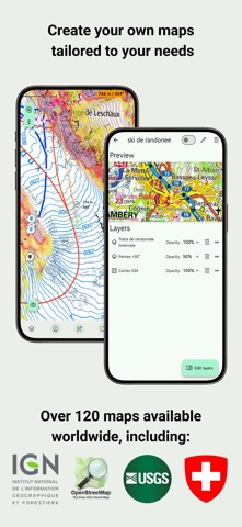
Discover CartoExplorer, the mapping app designed to accompany you on all your outdoor adventures. Wherever you are, thanks to its wide range of maps (USGS, Europe, worldwide), and whatever your activity (hiking, skiing, cycling…), from planning on your computer to tracking your progress on your mobile, CartoExplorer will quickly become your trusted partner in the field. Easy to use, CartoExplorer is a complete application that adapts to your needs. Explore the world with a rich variety of maps. CartoExplorer provides direct access to a vast library of high-quality base maps tailored for all your exploration and geographic analysis needs: - USGS Maps (United States): Navigate the vast territories of the U.S. with topographic maps from the United States Geological Survey (USGS). - IGN Maps (France): Benefit from the precision and detail of the National Institute of Geographic and Forest Information’s maps. Please note that access to certain IGN maps (IGN Maps, Topo25, and OACI) requires a specific subscription. - SwissTopo Maps (Switzerland): Discover the legendary accuracy of Swiss Federal Office of Topography’s maps. - IGN Maps (Spain): Explore the Iberian Peninsula with topographic maps from Spain’s National Geographic Institute (IGN). - World Maps: Travel across the globe with the power of OpenStreetMap and a wide variety of specialized base layers built on its data. among many others. CartoExplorer doesn’t just offer exceptional maps. It also provides a suite of intuitive and powerful tools to plan, record, and analyze your activities in the field: - Create and save tracks: Plan your routes easily directly on the map. Draw paths freehand or follow existing trails. Record your GPS movements in real time, view your track on the map, and monitor key data. Export and share your tracks in GPX format for use on other devices and platforms. - Follow tracks in real time: Import GPX tracks or select a created route and let CartoExplorer guide you. View your current position on the track and get real-time updates on remaining distance and estimated arrival time. - Place precise markers: Mark important points of interest on your map — summits, springs, viewpoints, campsites, incidents, and more. Customize markers with colors, names, icons, and descriptions. View GPS coordinates and easily share them with other users. - Define areas with polygons: Outline specific zones on the map by drawing polygons. Automatically calculate their surface area. Useful for identifying search zones, delimiting plots, or planning operations in targeted territories. - Manage your offline maps: Never let a lack of internet connection limit your explorations. CartoExplorer offers simple yet powerful offline management: automatic caching of viewed maps and precise offline downloads where you select the exact region you want to store locally. Some of these features (sharing, tracking, offline mode, etc.) are not available in the free version of the app. Unlock the full potential of CartoExplorer with our Premium subscription (€19.99/year) or Duo subscription (€29.99/year).
What's new · 26.9.2
Version 26.9 - Various improvements, fixes and updates # General improvements * Added a track optimization feature to reduce the number of points in a track. * Improved the outlier points filtering algorithm. * When importing a GPX file that contains only one track or one waypoint, the map now centers on it. * Added an indicator showing your current position when it goes off-screen. * Improved track following. * Improved the tool that generates the elevation profile when creating tracks. # Various fixes * Fixed linked waypoints visibility in the track details screen. * Fixed the E/W labels being swapped on the compass. # Updated various libraries
Details