

Salty Offshore
Ryan Coughlin · Sports
Independent analytics for this App Store listing. AppTracker is not affiliated with Ryan Coughlin.
Chart standing · US
What changed · US
Listing changes AppTracker has observed for this app in this storefront — new versions, price moves, rating shifts, and store copy.
Tides, a cleaner chart, and faster weather, right on the map you already fish from. New Features • Turn on Tide Stations and tap a station to see the next high or low, how long until it turns, and the full tide table. Improvements • Scrub weather through the hours as fast as you scrub the ocean. (Pro & up) • The navigation chart blends into the Salty map, with cleaner symbols and shallow water shaded by depth. • Every boat in view stays on the map when you zoom out. (Elite, or Pro can add it on) • Fill gaps uses every earlier pass from the same satellite, so more cloudy water fills in. (Pro & up) • 106 new fishing spots on the West Coast and in Baja. • New captains sign up in the app and get 15 minutes to try Salty before choosing a plan. Bug Fixes • Shared maps open with the same layers, depth, and pass the sender saved. • Playback shows each pass in its own temperature colors. • Coastlines show through the wind layer. (Pro & up) • The forecast table fits on screen. • Coordinate links open in the app even when the numbers are rounded.
Ratings breakdown · US
The star breakdown behind this app's rating in this storefront.
In-app purchases · US
What this app sells inside itself, grouped by kind and priced for this storefront.
Screenshots






Keywords this app targets
Search terms AppTracker associates with this app — estimates, not search volume. ❝ = in the app's title; a highlighted number is its current position for that term.
Similar apps
Competitors and close alternatives, as estimated by AppTracker.
 Sea Depth
Seadepth Charst
1 shared topic
Sea Depth
Seadepth Charst
1 shared topic
 Pêche en Mer - Predisport
Charles VENAYRE
Pêche en Mer - Predisport
Charles VENAYRE
 SeaPeople: Boat Tracker
SeaPeople, Inc.
SeaPeople: Boat Tracker
SeaPeople, Inc.
 SeaLegs AI
SeaLegs LLC
SeaLegs AI
SeaLegs LLC
 FishTrack - Charts & Forecasts
Surfline/Wavetrak
FishTrack - Charts & Forecasts
Surfline/Wavetrak
 SeaNav
Pocket Mariner Ltd.
1 shared topic
SeaNav
Pocket Mariner Ltd.
1 shared topic
 SailTies: Logbook GPS Tracking
Sail Ties Ltd
1 shared topic
SailTies: Logbook GPS Tracking
Sail Ties Ltd
1 shared topic
 SeaBase
Yeoman Ventures LLC
SeaBase
Yeoman Ventures LLC
About
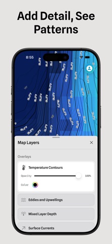
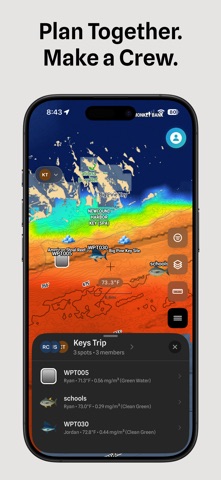
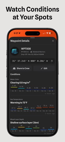
Learn from every day on the water. Salty brings ocean conditions and your own fishing history together. Compare the water before a trip. Record the run and mark bites as they happen. Review the trail and conditions afterward, so every trip adds to what you know. Read More of the Water • Compare sea surface temperature, chlorophyll, currents, salinity, mixed layer depth, and more • Refine the range and choose the colors • Add shaded relief to see the seafloor alongside ocean conditions Record the Day • Trip Tracker records your route, speed, and depth • Mark bites and catches from the Lock Screen or with Siri while a trip is active • Afterward, Salty adds ocean conditions along the trail for you to review Track Your Spots • Drop a waypoint and check its current conditions and recent changes • Create a watch for the range you care about • Salty notifies you when it is met Share the Exact View • Send a map link that opens the same region, layers, ranges, and satellite frame • Share waypoints with your crew as the day unfolds Know Your Data • See when satellite imagery was captured, how much water it covers, and which passes are available • Turn on alerts when new sea surface temperature or chlorophyll imagery arrives Prepare for Offshore • Save maps and layer setups for fast recall • Download supported regions before you lose service • Import and export GPX files between Salty and your chartplotter Start with a free preview. Compare the water, record your next trip, and keep a history you can learn from. Features and data availability vary by plan and region. Terms of Use (EULA): https://www.apple.com/legal/internet-services/itunes/dev/stdeula/ Privacy Policy: https://saltyoffshore.com/privacy
What's new · 3.9.41
Tides, a cleaner chart, and faster weather, right on the map you already fish from. New Features • Turn on Tide Stations and tap a station to see the next high or low, how long until it turns, and the full tide table. Improvements • Scrub weather through the hours as fast as you scrub the ocean. (Pro & up) • The navigation chart blends into the Salty map, with cleaner symbols and shallow water shaded by depth. • Every boat in view stays on the map when you zoom out. (Elite, or Pro can add it on) • Fill gaps uses every earlier pass from the same satellite, so more cloudy water fills in. (Pro & up) • 106 new fishing spots on the West Coast and in Baja. • New captains sign up in the app and get 15 minutes to try Salty before choosing a plan. Bug Fixes • Shared maps open with the same layers, depth, and pass the sender saved. • Playback shows each pass in its own temperature colors. • Coastlines show through the wind layer. (Pro & up) • The forecast table fits on screen. • Coordinate links open in the app even when the numbers are rounded.
Details